Langwies (Arosa)
| Langwies GR | ||
|---|---|---|
| State : |
|
|
| Canton : |
|
|
| Region : | Plessure | |
| Political community : | Arosa | |
| Postal code : | 7057 | |
| former BFS no. : | 3924 | |
| Coordinates : | 773 809 / 188 198 | |
| Height : | 1377 m above sea level M. | |
| Area : | 54.96 km² | |
| Residents: | 296 (December 31, 2012) | |
| Population density : | 5 inhabitants per km² | |
| Website: | www.gemeindelangwies.ch | |
| map | ||
|
|
||
Langwies (in the local Walser dialect at Wis or at the Lenggwis [ at dər (ling) 'ʋɪs ], Romansh ) was until 31 December 2012, a municipality in the former area of Schanfigg , district Plessur of the Swiss canton of Grisons .
On January 1, 2013, it merged with the municipalities of Calfreisen , Castiel , Lüen , Molinis , Peist and St. Peter-Pagig to form the municipality of Arosa .
coat of arms
Blazon : Blue club, overturned obliquely to the left in gold.
Motif based on a court seal from 1798. Colors of the Ten Court League .
geography

Langwies is 14 km (as the crow flies) east of Chur in the rear of Schanfigg , where three source valleys unite to form the main valley, which from then on moves westwards: from the south the Arosertal with the upper reaches of the Plessur , from the east the Sapün and from the northeast the Fondei .
On the western side of the valley, the former municipal area encompassed the Prätschwald from the river (around 1300 m above sea level ) to a rocky slope edge running at around 1800, up the valley to the narrow valley above the Litzirüti . Right of the Plessur included the territory of the entire catchment area of Fondeier- and Sapünerbach and beyond a 3 km long section of the Arosertals from the river to the ridge. Out of the valley the border of the mouth of the led woman ravine in the Plessur nearly in a direct line to the top of Mattjisch Horn (2461 m) and on to Chistenstein (2473 m), the northernmost point of the area. Beyond the Durannapass (2117 m) and the Casannapass (2233 m), which lead as wide saddles from Fondei into the middle Prättigau , the Weissflue - Strela chain (watershed against the Landwasser Valley ) formed the border to the Davos landscape . The ridge running from the Weissflue (2843 m, highest point in the former municipality) to the southwest over Schiahorn (2709 m), Chüpfenflue (2658 m), Mederger Flue (2674 m), Tiejer Flue (2781 m) to the Furggahorn (2727 m) is interrupted by the gap in the Strela pass (2350 m), which connects the rear Sapün with Davos.
In addition to today's main settlement, Langwies Platz on the right bank of the Plessur near the confluence of the Sapünerbach, the hamlets of Sunnenrüti and Litzirüti upstream are also inhabited all year round. In addition, the former community included a large number of former neighborhoods , mostly located on the sunny slope west of Langwies Platz, the Maiensäss Medergen and Pirigen as well as the scattered settlements of the Fondei (with Strassberg ) and Sapün valleys , which were earlier more important than Langwies Platz, but have only been used in summer since the 20th century.
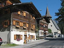
Alp Rongg ( Rhaeto-Romanic for clearing) belonged to Langwies . There are three houses on the Alp, one of which is inhabited all year round. There are also four other buildings as used or former stables. The buildings are Walser buildings from the 19th century, which are typical for the Schanfigg region.
Almost half of the entire former municipal area of almost 55 km² (exactly 2,675 ha) is used for agriculture, mostly as pasture land. 1,509 hectares are unproductive areas (mostly mountains in the north and east of the municipality). A further 1,237 hectares are covered by forest and wood and the remaining 64 hectares are settlement areas.
Neighboring communities were Peist , Fideris , Conters in the Prättigau , Klosters-Serneus , Davos and Arosa .
history
A few Graubünden Romanes have lived in the area since the 13th century. In 1307 the immigration of Walsers began . At first they only settled the high parts of the former community such as Fondei, Sapün and Medergen, later they also settled down into the valley. The German place name appears for the first time probably in 1300 (Petrus an der Wise), certainly 1384 as a name for the construction site of the new church to be built (guot called the Lang wise) . The much-cited document from 998 is a forgery from 1656. Because of failure to take into account new research results, this nonsense has partly been carried on into today's historiography. First the barons of Vaz ruled until 1338 , then various other lords until 1479, before the community came under the wing of the Habsburgs . The judicial community of Langwies, including Praden 10 km away, also populated by Walsers , enjoyed certain privileges, such as the free choice of Ammann. It belonged to the Ten Courts League since 1436 . Despite Austrian rule, the residents accepted the New ( Reformed ) Doctrine in 1530 , which the reformer Philipp Gallicius had also proclaimed here. In the Grisons turmoil in 1622, the residents fought violently against the advancing Austrian troops. Between 1652 and 1657 the residents bought themselves free from all sovereign and feudal rights.
population
| Population development | |||||
|---|---|---|---|---|---|
| year | 1850 | 1900 | 1950 | 2000 | 2005 |
| population | 385 | 285 | 383 | 303 | 297 |
Of the 285 residents at the end of 2004, 271 were Swiss citizens.
politics
The former municipal council consisted of five people. The last mayor was Dorothea Mattli-Salzgeber, the widow Jöri Mattlis .
economy
In the past, the population lived from agriculture, mainly cattle breeding. Today most of the employees earn their living directly or indirectly in tourism. As of 2000–01, 51 people were employed in agriculture and forestry, 4 in the commercial sector and 73 in the service sector.
tourism
In the districts of Platz and Litzirüti there are four hotels (around 6,500 overnight stays in 2005) and around 30 holiday apartments. Most of the houses in the hamlets of Fondei, Sapün and Medergen have been converted into holiday homes. Hiking and cycling tours can be undertaken in summer, and the slopes of the neighboring community of Arosa can be used in winter. Langwies itself offers winter hiking and sledding trails. The biggest event is the Arosa ClassicCar, which takes place every year in late summer .
traffic
The Schanfiggerstrasse leads through Langwies . The former community is connected to the public transport network through the Langwies GR and Litzirüti stations on the Rhaetian Railway's Chur – Arosa line, which opened in 1914 . Along with Arosa, Langwies would be a possible starting point for a currently visionary railway connection between Schanfigg and the Davos landscape.
Until 1877, the route over the Strela Pass to Davos was the most important connection to the outside world. With the completion of the Chur – Langwies road, the orientation towards Chur has changed. Since 1890 there has also been a road connection up to Arosa. The nearest motorway connection is Chur-Nord (from Sargans) or Chur-Süd (from Reichenau) on the A13 .
education
Already in the 17th century there was a kind of school instruction in the community at that time. In the 19th century, the village school commuted between the three large settlements Fondei, Sapün and Langwies village or was run in parallel. Since 1903 there is only one school in the village. There is currently a kindergarten and a comprehensive school for the 1st to 6th primary school classes in town .
Attractions
The landmark of Langwies is the Langwieser Viaduct of the Rhaetian Railway, completed in 1914 , which spans the Plessur and Sapünerbach as a 284 m long reinforced concrete structure at a height of 62 m.
Also worth seeing are the earth pyramids called Steinmannli and the Gründjitobel viaduct in the Gründjitobel , near the western municipal boundary .
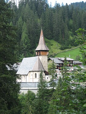
Also worth seeing is the reformed village church , which was called Marienkirche until the Reformation . The tower, the walls of the nave and some paintings come from the first church building from the years 1384–85. In 1488 it was rebuilt in the late Gothic style.
Personalities
Others
Since the women allegedly fought back the advancing Austrian troops in the so-called Frauentobel on the border between Ausser- and Innerschanfigg in 1622, they are always the first to go to the Lord's Supper when attending church services.
One of the most famous Walser folk songs is the Langwieser Lied with the entry line Mis Büeli geit over Sapünersteg i .
In 1985 a 16.5 gram stone meteorite of the type H6 was found half a kilometer south of the village . He was registered under the official name of Langwies.
literature
- Jürg Simonett: Langwies (Arosa). In: Historical Lexicon of Switzerland .
- Hans Danuser / Walser Association Graubünden (ed.): Old ways in Schanfigg . Publishing house Walser Association Graubünden, Splügen 1997.
- C. Fischer: Land and people in the Schanfigg valley . Manatschal Ebner & Cie., Chur 1905.
- Fritz Maron, Ferdinand Zai: The old Eggahaus in Arosa. A local museum for the Schanfigg valley . Self-published by the Association for Nature Conservation and Local History Arosa, Arosa (no year around 1948).
- Erwin Poeschel : The art monuments of the canton of Graubünden II. The valley communities Herrschaft, Prättigau, Davos, Schanfigg, Churwalden, Albula valley. (= Art Monuments of Switzerland. Volume 9). Edited by the Society for Swiss Art History GSK. Bern 1937. DNB 811066703 .
Web links
Individual evidence
- ↑ a b Lexicon of Swiss Community Names , ed. from the Center de Dialectologie at the University of Neuchâtel under the direction of Andres Kristol, Frauenfeld / Lausanne 2005, p. 507.
- ↑ Jenny commissioned to work out a suitability and feasibility study for a Schanfigg - Davos rail tunnel from October 21, 2008.
- ↑ Langwies. Meteoritical Bulletin, accessed June 30, 2020 .


