
Středočeský kraj
|
Středočeský kraj Central Bohemian Region |
|
|---|---|
coat of arms  |
flag  |
| map | |
  |
|
| Basic data | |
| Historic country : | Bohemia |
| Administrative headquarters : |
Prague (not part of the region) |
| Biggest town: | Kladno |
| ISO 3166-2 : | CZ-20 |
| Residents : | 1,369,332 (January 1, 2019) |
| Population density : | 105 inhabitants per km² |
| Vehicle registration number : | S. |
| geography | |
| Area : | 11,014 km² |
| Expansion: | North-South: 80 - 120 km West-East: up to 143 km |
| The highest point: | 864 m nm |
| Deepest point: | 153 m nm |
| Administrative division | |
| Districts : | 12 |
| Municipalities total: | 1,148 |
The Středočeský kraj ( German Central Bohemian Region ) is the largest of the 14 regions in the Czech Republic in terms of area .
The region covers a large part of western Czech Republic and is enclosed by the regions of Liberec , Hradec Králové , Pardubice , Vysočina , South Bohemia , Pilsen and Ústí nad Labem , while the core, the urban area of Prague , is politically independent and administratively independent Region forms.
Including Prague, the region corresponds to the historical region of Central Bohemia.
Administrative division
Districts (okresy)

The region consists of 1,148 municipalities, which are divided into twelve districts. The largest district is Benešov , the most populous is Praha-východ . The respective number of municipalities is given in brackets.
|
|
politics
Jaroslava Pokorná Jermanová ( ANO ) has been the regional governor (Hejtmanka) of the region since 2016 . She holds this position as the sixth Hejtman after Miloš Petera (2014–2016, ČSSD ), Josef Řihák (2012–2014, ČSSD), Zuzana Moravčíková (2012, ČSSD), David Rath (2008–2012, ČSSD) and Petr Bendl (2000 -2008, ODS ).
In the last elections of the regional parliament in 2016, ANO achieved the strongest result with 20.76% and thus 16 out of 65 seats. STAN followed as the second strongest force with 18.43% and 15 seats. The social democratic ČSSD (previously the strongest force) only achieved 13.75% (11 seats), closely followed by the conservative ODS with 13.05% (10 seats). The communist KSČM received 10.13% of the vote (8 seats) and the bourgeois TOP 09 6.54% (5 seats). 23.85% of the votes cast failed because of the 5% threshold .
The regional council, consisting of 11 people, is formed by 4 members each from ANO (including Hejtmanka) and STAN as well as 2 members from ODS and 1 member from the Independent (Nezávislí Středočeši).
geography
landscape
The Central Bohemian Region lies in the so-called Bohemian Pan . The north and east are plains, the south and south-west are hilly. The highest point in the region is the Tok (864 m) in the Brdská vrchovina (Brdy mountainous region ), the lowest point is the Elbe north of Mělník (153 m). The land used by agriculture takes up 61% of the area. The soil usually consists of black, high-yielding soil with a high proportion of humus . In higher areas, brown soil predominates. In the hilly areas, sandy soil predominates. Forests take up 28% of the area. While clearing is quite advanced in the north, the areas of Dobříš, Rožmitál and along the Sázava River are rich in forests.
Biggest cities
There is no big city in the Central Bohemian Region. 43% of all residents live in communities with fewer than 2,000 inhabitants.
| city | Residents (January 1, 2017) |
|---|---|
| Kladno | 68,660 |
| Mladá Boleslav | 44.056 |
| Příbram | 32,897 |
| Kolín | 31,123 |
| Kutná Hora | 20,405 |
| Beroun | 19.307 |
| Mělník | 19,295 |
| Brandýs nad Labem-Stará Boleslav | 18,507 |
| Kralupy nad Vltavou | 18,079 |
| Benešov | 16,544 |
| Neratovice | 16,267 |
| Rakovník | 15,975 |
| Slaný | 15,505 |
| Říčany | 15,236 |
| Nymburk | 14,951 |
| Poděbrady | 14,025 |
| Čelákovice | 12.114 |
| Vlašim | 11,641 |
| Čáslav | 10,375 |
| Lysá nad Labem | 9,460 |
| Dobříš | 8,995 |
| Mnichovo Hradiště | 8,588 |
| Sedlčany | 7,227 |
| The districts in numbers | ||||
|---|---|---|---|---|
| Circles | surface | Pop. | Age (Ø) | |
| Benešov | 1,524 | 97,452 | 42.1 | |
| Beroun | 662 | 91,230 | 41.1 | |
| Kladno | 692 | 163.108 | 41.6 | |
| Kolín | 846 | 99,610 | 41.7 | |
| Kutná Hora | 917 | 74,697 | 42.8 | |
| Mělník | 712 | 106,516 | 41.2 | |
| Mladá Boleslav | 1,058 | 126,825 | 41.3 | |
| Nymburk | 876 | 97,894 | 41.0 | |
| Prague (East) | 584 | 171.914 | 38.5 | |
| Prague (West) | 586 | 140.208 | 38.8 | |
| Příbram | 1,628 | 114.219 | 42.4 | |
| Rakovník | 930 | 55,309 | 42.3 | |
In the Central Bohemian Region there is also the small community Lidice (565 inh.), Made famous by the massacre of the National Socialists on June 9, 1942 as a reaction to the assassination attempt by Czech resistance fighters on the "Reich Protector of Bohemia and Moravia" Reinhard Heydrich .
Rivers
population
Demographics
Demographic development turned for the better in the second half of the 1990s with the construction of additional satellite cities. While natural population growth is declining, migration causes a steady increase in population. In 2001 the region was the only one in the Czech Republic with a positive population balance.
life quality
The quality of life has steadily improved since the 1990s. The emissions by coal-fired power plants and the chemical industry fell sharply. The water quality has also developed positively.
Living quality
The proportion of family houses is 91.3%, which is above the state average. However, the proportion of houses with a connection to the sewer system, water or gas is below the national average.
climate
Warm, pleasant climate with the warmest region of Bohemia in the valleys of Moldau and Elbe creates good conditions for agriculture. However, dry summers have had a negative impact recently.
economy
The region has a high proportion of industrial settlements, but is also important for agriculture, especially with a productive area in the Elbe Valley (wheat, grain, sugar beet, fruit and vegetables). In the field of services, there has been an increased growth in recent years. Many found employment in administrations, in trade, in the cultural sector and in sports facilities.
The Škoda Auto car plant in Mladá Boleslav is of great importance in the industrial sector and is of particular importance to many suppliers in the area. There are also some large mechanical engineering companies, the chemical industry ( Spolana ), the food industry, the printing industry and glass and ceramic manufacturers. The importance of steel manufacturers and coal mining has declined - especially in the Kladno district.
The unemployment is the end of March 2017 3.97% below the national average (4.79%), being near Prague (Praha východ-Okres 1.67%) is much lower than in the Kladno District with 5.87% . The share in the gross national product was 9.2% in 2001.
tourism
The whole area offers many vacation options, especially on the Berounka , Sázava and Vltava rivers and is especially popular for weekend vacations, which are popular with the Czechs.
The highest concentration of monuments can be found near Kutná Hora (Cathedral of St. Barbara, Vlašský Dvůr (Welscher Hof), ossuary in Sedlec). Some of the cultural monuments are protected by UNESCO . Protected monuments can also be found in Kolín . Also known Karlštejn and Točník in Beroun District , Křivoklát in Rakovník , Český Šternberk , Kost Castle in Mladá Boleslav and Kokořín in Mělník . Significant locks are Konopiště , Castle Žleby and kačina at Kutna Hora, Lány Castle and Nelahozeves . Important ruins Trosky , Žebrák and Okoř Castle . Valuable natural landscape can be found in the Křivoklát area with biosphere reserves, in the Kokořín Nature Park , in Český kras , Český ráj and in the Blaník Nature Park .
Mělník at the confluence of the Elbe and Vltava rivers

Market square in Mělník

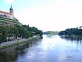
Where the Vltava flows into the Elbe

UNESCO World Heritage Kutná Hora


traffic
Besides Prague, the Central Bohemian Region has the densest transport network, but it also has the highest congestion in the republic. In addition to road traffic and the railroad, water traffic also plays an important role. About three quarters of all water logistics in the country are handled in the Central Bohemian Region. Esko , a suburban railway system comparable to the S-Bahn , operates in the greater Prague area .
Web links
- Homepage of the region (Czech, English, German, French, Spanish, Italian)
- Czech Statistical Office: statistical information on the region (Czech)
Individual evidence
- ↑ rozdělení křesel. Retrieved September 23, 2017 (Czech).
- ↑ Členové Rady kraje. Retrieved September 23, 2017 (Czech).
Coordinates: 50 ° 0 ' N , 14 ° 33' E