
Mikulov v Krušných horách
| Mikulov | |||||
|---|---|---|---|---|---|
|
|||||
| Basic data | |||||
| State : |
|
||||
| Region : | Ústecký kraj | ||||
| District : | Teplice | ||||
| Area : | 319.0603 ha | ||||
| Geographic location : | 50 ° 41 ' N , 13 ° 43' E | ||||
| Height: | 595 m nm | ||||
| Residents : | 249 (Jan. 1, 2019) | ||||
| Postal code : | 419 01 | ||||
| License plate : | U | ||||
| traffic | |||||
| Street: | Hrob - Moldava | ||||
| Railway connection: | Most – Moldava | ||||
| structure | |||||
| Status: | local community | ||||
| Districts: | 1 | ||||
| administration | |||||
| Mayor : | Ota Stehno (as of 2013) | ||||
| Address: | Tržní náměstí 27 419 01 Mikulov |
||||
| Municipality number: | 567701 | ||||
| Website : | www.obecmikulov.cz | ||||
| Location of Mikulov in the Teplice district | |||||

|
|||||
.png)

Mikulov ( German Niklasberg ) is a municipality in Ústecký kraj in the Czech Republic .
geography

location
The locality is located in Northern Bohemia in 595 m nm height at the southern slope of the Ore Mountains , about 14 km northwest of Teplice ( Teplitz ) at the old Freiberg Teplitzer Post Road between Moldava ( of Moldova ) on the crest and Hrob ( Kloster grave ) at the foot of the Ore. In the northeast, at 909 m, rises the second highest mountain in the Eastern Ore Mountains , the Pramenáč ( Bornhauberg ) and in the west the 869 m high Bouřňák ( Stürmer ).
Community structure
No districts are shown for the municipality of Mikulov. The one-layer Vitiška ( Wittichbaude ) belongs to Mikulov .
Neighboring places
| Altenberg | ||
| Moldava (Moldova) |
.svg)
|
Košťany (costs) |
| Hrob (monastery tomb) |
history


The place was founded in 1540 under the name Neuschellenberg as a settlement of Saxon miners by Count Lobkowitz . The oldest document of the place concerns a privilege granted by Emperor Ferdinand I on May 7, 1543 to the three brothers Johann Litwin, Christoph and Wenzel von Lobkowitz on Bilin , Tein and Dux . On February 11, 1554, the Lobkowitz brothers gave the community a printed mountain ordinance, thus taking the first step in the development of the town into a mountain town. In 1596 Emperor Rudolf II gave the town a coat of arms and elevated it to a mountain town. The privileges of the town were regularly confirmed by the sovereigns until the 19th century. After mining came to an end, the population laboriously subsisted on farming. Since the opening of the Most – Moldava railway line , which used to be known as the “Teplitz Semmering Railway”, tourism slowly developed, first as a summer resort, and later also as winter sports.
After the First World War , Niklasberg was incorporated into the newly created Czechoslovakia in 1919 . Due to the Munich Agreement the city from 1938 to 1945 for belonging district Teplice , Region of Usti nad Labem , in the German Reich District of Sudetenland . The German residents were expropriated and expelled in 1945 . The town charter was revoked.
Demographics
Until 1845 Niklasberg was predominantly populated by German Bohemia , which were expelled.
| year | Residents | Remarks |
|---|---|---|
| 1830 | 571 | in 96 houses |
| 1844 | 637 | in 110 houses |
| 1857 | 620 | |
| 1869 | 531 | |
| 1880 | 564 | |
| 1890 | 576 | |
| 1900 | 606 | |
| 1910 | 664 | |
| 1921 | 612 | 595 of them German |
| 1930 | 739 | |
| 1939 | 561 |
| year | 1950 | 1961 | 1970 | 1980 | 1991 | 2001 | 2011 |
| Residents | 271 | 220 | 186 | 136 | 143 | 150 | 218 |
coat of arms
The city coat of arms awarded by Emperor Rudolf II in 1596 shows a city wall with a city gate on a shield. Above the city gate is St. Nicholas depicted with a scepter, below the emblem of the mining industry.
gallery
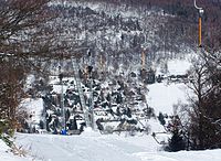
Town seen from the striker in winter time


Web links
- Obec Mikulov (German, Czech, English, French)
- Old views of Niklasberg
Individual evidence
- ↑ http://www.uir.cz/obec/567701/Mikulov
- ↑ Český statistický úřad - The population of the Czech municipalities as of January 1, 2019 (PDF; 7.4 MiB)
- ^ Johann Thaddäus Anton Peithner von Lichtenfels : Attempt on the natural and political history of the Bohemian and Moravian mines . Vienna 1780, pp. 87-88, § 89.
- ↑ Jaroslaus Schaller : Topography of the Kingdom of Bohemia . Volume 5: Leutmeritzer Kreis , Vienna 1787, pp. 125–126, paragraph 20.
- ↑ Kaspar Maria von Sternberg : Outlines of a history of the Bohemian mines . Prague 1836, p. 458 .
- ↑ Kaspar Maria von Sternberg : Outlines of a history of the Bohemian mines . Prague 1836, p. 454 .
- ^ A b Johann Gottfried Sommer : The Kingdom of Bohemia . Volume 1: Leitmeritzer Kreis , Prague 1833, pp. 122–123, item 33.
- ↑ Yearbooks of the Bohemian Museum of Natural and Regional Studies, History, Art and Literature . Volume 2, Prague 1831, p. 198, paragraph 29.
- ^ Friedrich Carl Watterich von Watterichsburg: Handbook of regional studies of the Kingdom of Bohemia . Prague 1845, p. 932.
- ^ Pierer's Universal Lexicon . Volume 11, Altenburg 1860, p. 953.
- ^ Genealogy Sudetenland
- ^ A b Michael Rademacher: German administrative history from the unification of the empire in 1871 to the reunification in 1990. Teplitz-Schönau district. (Online material for the dissertation, Osnabrück 2006).
- ↑ Historický lexikon obcí České republiky - 1869-2015. Český statistický úřad, December 18, 2015, accessed on January 25, 2016 (Czech).