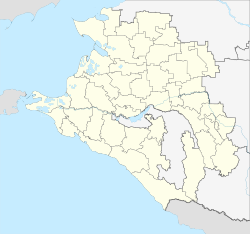
Oktyabrskaja (Krasnodar, Krylowski)
| Staniza
Oktyabrskaya
Октябрьская
|
||||||||||||||||||||||||||||||||||||||
|
||||||||||||||||||||||||||||||||||||||
|
||||||||||||||||||||||||||||||||||||||
| List of large settlements in Russia | ||||||||||||||||||||||||||||||||||||||
Oktyabrskaya ( Russian Октябрьская ) is a Staniza in the Krasnodar region in Russia with 11,252 inhabitants (14 October 2010).
geography
The place is in the foothills of the Caucasus a good 150 km as the crow flies north-northeast of the regional administrative center Krasnodar , on the upper reaches of a small right tributary of the left Jeja tributary Sossyka .
Oktyabrskaya belongs to the Krylovsky district and is located a good 10 km west-southwest of its administrative center Krylovskaya . Stanitsa is the seat of the rural community of Oktyabrskoje selskoje posselenije, which also includes the settlements of Kowaljowka (22 km away), Obilny (10 km), Reshetilovsky (27 km), Saprudny (15 km) and Temp (5 km), all in an east-southeast direction , as well as the hamlet (chutor) Sborny (5 km south) belong.
history
The place was created in 1870 under the name Michailowka in connection with the construction of the Rostov-on-Don - Vladikavkaz railway line , which went into continuous operation in 1875, not far from the Yekaterinovskaya station , which was built there for Stanitsa of the same name, now Krylovskaya. In 1906 the place received the status of a Stanitsa under the name Novomichailowskaja ("New Michailowskaja"; a Staniza Michailowskaja had existed since 1845 north of today's Kurganinsk ).
In 1963 Stanitsa was combined with the western hamlet of Oktjabrski, with which it had grown together in the meantime, and received its current name from Russian oktjabr for October, with the reference to the October Revolution widespread in the Soviet Union .
Population development
| year | Residents |
|---|---|
| 1959 | 6,683 |
| 1979 | 10,235 |
| 2002 | 11,460 |
| 2010 | 11,252 |
Note: census data
traffic
In Oktyabrskaja there is the Krylovskaja railway station (until 1961 Ekaterinovskaya ) at kilometer 1468 (from Moscow) of the Rostov - Vladikavkas / - Makhachkala - Baku railway line electrified on this section since 1962 .
To the east, Stanitsa is bypassed by the federal highway M4 Moscow - Rostov-on-Don - Krasnodar - Novorossiysk (also European route 115 ). To the northeast, the 03N-269 regional road branches off to Krylowskaja, and to the southeast the 03K-275, which connects all the settlements belonging to the municipality (from Temp to Reshetilovsky). In a westerly direction the 03K-051 leads to Leningradskaya , to the south the 03K-056 runs parallel to the M4 to Pavlovskaya and on to Novoplastunovskaya .
Web links
- Official website of the local government (Russian)
Individual evidence
- ↑ a b Itogi Vserossijskoj perepisi naselenija 2010 goda. Tom 1. Čislennostʹ i razmeščenie naselenija (Results of the All-Russian Census 2010. Volume 1. Number and distribution of the population). Tables 5 , pp. 12-209; 11 , pp. 312–979 (download from the website of the Federal Service for State Statistics of the Russian Federation)


