Kawkasskaya
| Staniza
Kawkasskaya
Кавказская
|
||||||||||||||||||||||||||||||||
|
||||||||||||||||||||||||||||||||
|
||||||||||||||||||||||||||||||||
| List of large settlements in Russia | ||||||||||||||||||||||||||||||||
Kawkasskaja ( Russian Кавка́зская ) is a stanitsa in the Krasnodar region in Russia with 11,164 inhabitants (as of October 14, 2010).
geography
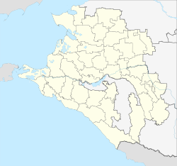
The place is in the foothills of the Caucasus, about 140 km as the crow flies east-northeast of the regional administration center Krasnodar . It is located on the right bank of the Kuban , which rises steeply more than 70 m above the level of the river.
Kawkasskaya belongs to the Kawkassky Rajon and is located about 8 km east of the center of its administrative seat, the city of Kropotkin . It is the seat and the only locality of the rural municipality Kawkasskoje selskoje posselenije. The town of Gulkewitschi , the administrative seat of the southern neighboring rayon , is located about 10 km south of the Kuban .
history
The Stanitsa goes back to a fortress built a little further east from 1778, which was part of the Azov - Mozdoker defense line planned and built under Suworow along the border of the Russian Empire to the Caucasus, which followed the Kuban on this section. At first her name was Temischbek after the old name of the place, but already from 1779 Pavlovskaya after the heir to the throne Pawel (Paul). After a renovation under General Ivan Gudowitsch in 1793, the fortress was named Kawkasskaja, from Russian Kawkas for Caucasus .
1794 were not far from the fort Staniza Romanovskaya originating Don Cossacks settled. Later this settlement became a stanitsa of the Kuban Cossacks , as the fortress is called Kawkasskaya . After the Rostov - Vladikavkas railway line had passed a few kilometers to the west of the hamlet of Romanovsky on the Stanitsa estate in 1875, a larger settlement developed around the Kawkasskaya railway station built there, especially after the branch lines to Stavropol and Krasnodar that began there in 1897 In 1901 Stanitsa surpassed the economic importance of today's city of Kropotkin. The Stanitsa Kawkasskaja was from 1876 to 1924 the administrative seat of one of the seven "departments" (otdel) of the Kuban area (Kubanskaja oblast).
During the Second World War , Staniza was occupied by the German Wehrmacht from the summer of 1942 to the beginning of 1943 . After Kropotkin was spun off as a "regional subordinate city" from the Kropotkinski rajon , which had existed since 1937 , its administration was relocated to Kawkasskaja on January 25, 1944 and the raion was renamed Kawkasski . Stanitsa remained the center of the Rajon until 1956, when the administration was moved back to Kropotkin. On October 20, 1980, Kawkasskaja was again the administrative seat of the Kawkasski rajon. As part of the administrative reform in Russia, the previously rajon-free city of Kropotkin was then reintegrated into the Kawkasski rajon on August 8, 2008 and its administration relocated to there again, although the former Rajon name was retained.
Population development
| year | Residents |
|---|---|
| 1897 | 8,293 |
| 1939 | 6,204 |
| 1959 | 7,530 |
| 1979 | 9,398 |
| 1989 | 10,755 |
| 2002 | 11,531 |
| 2010 | 11,164 |
| 2015 | 10,705 |
Note: census data
traffic
At Kawkasskaya, Getmanovskaya station is at kilometer 12 of the Kropotkin railway line ( Kawkasskaya station ) - Palagiada (near Stavropol ) - Svetlograd (- Elista ). The electrified section of the line has ended in Getmanovskaya since 1982 . To the north of the Stanitsa the regional road 03K-002 runs past, coming from Temryuk via Krasnodar, crossing the federal highway R217 Kawkas (formerly M29) near Kropotkin and continuing to the neighboring Stavropol region about 20 km away ; there continue in the direction of Novoalexandrovsk - Isobilny - Stavropol.
Web links
Individual evidence
- ↑ a b Itogi Vserossijskoj perepisi naselenija 2010 goda. Tom 1. Čislennostʹ i razmeščenie naselenija (Results of the All-Russian Census 2010. Volume 1. Number and distribution of the population). Tables 5 , pp. 12-209; 11 , pp. 312–979 (download from the website of the Federal Service for State Statistics of the Russian Federation)


