
Taman (Krasnodar)
| Staniza
Taman
Тамань
|
||||||||||||||||||||||||||||||||||||||
|
||||||||||||||||||||||||||||||||||||||
|
||||||||||||||||||||||||||||||||||||||
| List of large settlements in Russia | ||||||||||||||||||||||||||||||||||||||
.png)
.png)
.svg)

Taman ( Russian Тамань ) is a Staniza in the Krasnodar region in Russia with 10,027 inhabitants (14 October 2010).
geography
The place is located on the Taman peninsula of the same name, about 180 km as the crow flies west of the regional administrative center of Krasnodar , on the southern bank of Taman Bay on the Kerch Strait between the Black and Azov Seas .
Taman belongs to Temrjukski Rajon and is located about 50 km west-southwest of its administrative center Temryuk . The Stanitsa is the seat of the rural community Tamanskoje selskoje posselenije, which also includes the settlement Volna (translated "wave"), 8 km south on the Black Sea coast.
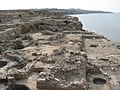
Excavations of Hermonassa / Tmutarakan in Taman

Protection and Intercession Church

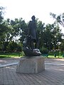
Memorial to the first Cuban Cossacks ( Amandus Adamson , 1911)
Lermontov Monument
Cossack open-air museum “Ataman”, opened in 2009


history
On the territory of today's Stanitsa was since the 6th century BC. The ancient Greek colony Hermonassa , later under the Khazars as Tumantarchan and from the 11th century temporarily Russian as Tmutarakan . From the 12th century the area was in Kipchak (Cuman) , Genoese and Ottoman hands, with the actual city falling into disrepair by the 14th century at the latest.
The present place was founded in 1792 after the area fell to the Russian Empire as a result of the Russo-Austrian Turkish War , by Cossacks who landed there and who had been in the region since the 17th century. It later remained the location of the Cossack flotilla , was considered a city until 1849, then officially became Stanitsa and belonged to the Temryuk department (otdel) of the Kuban Oblast .
During the Second World War , Taman, like the entire peninsula, was part of the Kuban bridgehead from spring to autumn 1943, the scene of heavy retreat fighting by the German Wehrmacht and was significantly destroyed.
Population development
| year | Residents |
|---|---|
| 1939 | 7,993 |
| 1959 | 5,235 |
| 1979 | 8,343 |
| 2002 | 9,297 |
| 2010 | 10,027 |
Note: census data
traffic
The regional road 03N-490 leads to Taman, which branches off about 25 km east-northeast near the settlement of Sennoi (not far from ancient Phanagoria ) from the federal highway A290 (formerly M25) Novorossiysk - Port Kawkas and follows the south bank of Taman Bay. In an initially south-easterly direction, a smaller road runs from Taman via Wyschesteblijewskaja to Starotitarowskaja , also on the A290.
The closest train station, Taman, is located in Sennoi at kilometer 111 of the Krymskaja - Port Kawkas line, which opened on this section in 1954 . From this, a freight connection line branches off further south to the Taman deep-water port on the Black Sea, which has been under construction since 2007, not far from the Wolna settlement, the first section of which has been in operation since 2009. Its main purpose is to handle crude oil , liquid gas , ammonia and grain.
Sons and daughters of the place
- Lyudmila Schewzowa (* 1934), athlete, Olympic champion 1960.
Web links
- Official website of the local government (Russian)
Individual evidence
- ↑ a b Itogi Vserossijskoj perepisi naselenija 2010 goda. Tom 1. Čislennostʹ i razmeščenie naselenija (Results of the All-Russian Census 2010. Volume 1. Number and distribution of the population). Tables 5 , pp. 12-209; 11 , pp. 312–979 (download from the website of the Federal Service for State Statistics of the Russian Federation)
Anapskaya | Anastassievskaya | Bryukhovetskaya | Kholmskaya | Dinskaya | Yelisavetinskaya | Kalininskaya | Kanevskaya | Kazanskaya | Kawkasskaya | Krylovskaya | Kushchevskaya | Ladozhskaya | Leningradskaya | Marjanskaya | Medvedovskaya | Novominskaya | Novomyshastovskaya | Novopokrovskaya | Novotitarovskaya | Oktyabrskaya | Otradnaya | Pavlovskaya | Petrovskaya | Plastunovskaya | Platnirovskaya | Poltavskaya | Rajevskaya | Severskaya | Staroderevyankovskaya | Starokorsunskaya | Starominskaya | Staromyshastovskaya | Staronischesteblijewskaja | Staroshcherbinovskaya | Starotitarovskaya | Starovelichkovskaya | Taman | Tbilisskaya | Varenikovskaya | Vasyurinskaya | Wysselki