Passadumkeag
| Passadumkeag | ||
|---|---|---|
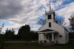
 District No. 2 schoolhouse |
||
| Location in Maine | ||
|
|
||
| Basic data | ||
| Foundation : | January 31, 1835 | |
| State : | United States | |
| State : | Maine | |
| County : | Penobscot County | |
| Coordinates : | 45 ° 12 ′ N , 68 ° 36 ′ W | |
| Time zone : | Eastern ( UTC − 5 / −4 ) | |
| Residents : | 374 (as of 2010) | |
| Population density : | 6.3 inhabitants per km 2 | |
| Area : | 59.75 km 2 (approx. 23 mi 2 ) of which 59.36 km 2 (approx. 23 mi 2 ) are land |
|
| Height : | 45 m | |
| Postal code : | 04475 | |
| Area code : | +1 207 | |
| FIPS : | 23-57045 | |
| GNIS ID : | 0582663 | |
| Website : | passadumkeagmaine.org | |
Passadumkeag is a town in Penobscot County in the state of Maine in the United States . In 2010 there were 374 inhabitants in 197 households on an area of 59.75 km².
geography
According to the United States Census Bureau , Passadumkeag has a total area of 59.75 km², of which 59.36 km² is land and 0.39 km² consists of water .
Geographical location
Passadumkeag is centrally located in Penobscot County. The western boundary of the area is formed by the Penobscot River , which flows in a southerly direction . The Passadumkeag River , which flows in a westerly direction, flows into it . The surface is flat.
Neighboring communities
All distances are given as straight lines between the official coordinates of the places from the 2010 census.
- North: Enfield , 6.4 mi
- East: Lowell , 4.5 miles
- South: Greenbush , 8.4 miles
- West: Argyle , Unorganized Territory, 9.4 mi
City structure
There are two settlement areas in Passadumkeag : Passadumkeag and Passadumkeag Point .
climate
The mean mean temperature in Passadumkeag is between −9.4 ° C (15 ° F ) in January and 20.6 ° C (69 ° F) in July. This means that the place is around 9 degrees cooler than the long-term average in the USA. The snowfalls between October and May are up to two and a half meters, more than twice as high as the average snow depth in the USA; the daily sunshine duration is at the lower end of the range in the USA.
history
First, the area of Township No. 1 Old Indian Purchase, East of Penobscot River (T1 OIP EPR ) or Lower East Indian Township No. 1 called. Passadumkeag was organized as a town on January 31, 1835. In 1842, land was given to Lowell.
Population development
| Census Results - Town of Passadumkeag, Maine | ||||||||||
|---|---|---|---|---|---|---|---|---|---|---|
| year | 1800 | 1810 | 1820 | 1830 | 1840 | 1850 | 1860 | 1870 | 1880 | 1890 |
| Residents | 269 | 394 | 295 | 360 | 243 | 302 | 343 | |||
| year | 1900 | 1910 | 1920 | 1930 | 1940 | 1950 | 1960 | 1970 | 1980 | 1990 |
| Residents | 409 | 445 | 354 | 325 | 277 | 331 | 355 | 326 | 430 | 428 |
| year | 2000 | 2010 | 2020 | 2030 | 2040 | 2050 | 2060 | 2070 | 2080 | 2090 |
| Residents | 441 | 374 | ||||||||
Culture and sights
Buildings
In Passadumkeag, a building was placed under a preservation order and included in the National Register of Historic Places .
- District No. 2 School , 1997 under the register no. 97000309.
Economy and Infrastructure
traffic
The US Highway 2 parallel in a north-south direction to the Penobscot River along the western edge of the Town.
Public facilities
There are no medical facilities or hospitals in Passadumkeag. Closest facilities for Passadumkeag residents are in Howland.
Passadumkeag does not have its own library. The closest are in Enfield, Howland and Lincoln.
education
Passadumkeag is part of School Administrative Unit 31 with Burlington, Lowell, Edinburg, Enfield, Howland, Maxfield and Seboeis. The following schools are available in the school district:
- Penobscot Valley High School in Howland, with classes from 9th to 12th grade
- Hichborn Middle School in Howland, with school classes from 6th to 8th grade
- Enfield Station School in Enfield, with school classes from pre-kindergarten through 5th grade
Web links
Individual evidence
- ↑ Passadumkeag in the Geographic Names Information System of the United States Geological Survey , accessed on November 23, 2019
- ↑ Maine 2010 Census Results ; official publication of the Census Authority, (English; PDF; 32.5 MB)
- ↑ Coordinates of the locations of the Census Authority 2010
- ↑ a b Passadumkeag, Maine. In: mainegenealogy.net. Retrieved November 23, 2019 .
- ↑ a b Passadumkeag, Maine (ME 04475) profile: population, maps, real estate, averages, homes, statistics, relocation, travel, jobs, hospitals, schools, crime, moving, houses, news, sex offenders. In: city-data.com. www.city-data.com, accessed on November 23, 2019 .
- ↑ Population 1830–2010 according to census results
- ↑ District No. 2 School 97000309
- ^ School Administrative District 31. In: sau31.org. Retrieved May 4, 2019 .

