Perito
| Perito | ||
|---|---|---|

|
|
|
| Country | Italy | |
| region | Campania | |
| province | Salerno (SA) | |
| Coordinates | 40 ° 18 ′ N , 15 ° 9 ′ E | |
| height | 460 m slm | |
| surface | 23 km² | |
| Residents | 876 (Dec. 31, 2019) | |
| Population density | 38 inhabitants / km² | |
| Post Code | 84060 | |
| prefix | 0974 | |
| ISTAT number | 065092 | |
| Popular name | peritesi | |
| Website | Perito | |
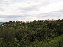
Perito is a municipality with 876 inhabitants (as of December 31, 2019) in southwest Italy in the province of Salerno ( Campania region ). The place is part of the National Park Cilento and Vallo di Diano , as well as the Comunità Montana Zona del Gelbison e Cervati .
geography
The place is in the west of the Cilento National Park , about 2 km south of the Alento reservoir. The municipality Ostigliano, which is located north of the main town, also belongs to the municipality. The neighboring municipalities are Cicerale , Lustra , Monteforte Cilento , Orria , Prignano Cilento , Rutino and Salento .
Perito is located on a slope in the Alento Valley and is easily accessible from Agropoli via the SS18 . The place is part of the National Park Cilento and Vallo di Diano .
Web links
Individual evidence
- ↑ Statistiche demografiche ISTAT. Monthly population statistics of the Istituto Nazionale di Statistica , as of December 31 of 2019.


