
Satka
| city
Satka
Сатка
|
||||||||||||||||||||||||||||||||||||||||||
|
||||||||||||||||||||||||||||||||||||||||||
|
||||||||||||||||||||||||||||||||||||||||||
| List of cities in Russia | ||||||||||||||||||||||||||||||||||||||||||
.png)
.png)
.svg)

Satka ( Russian Сатка ) is a city in Chelyabinsk Oblast ( Russia ) with 45,178 inhabitants (as of October 14, 2010).
geography
The city is located on the western flank of the Southern Urals about 230 km west of the Oblast capital Chelyabinsk at the confluence of the Malaya Satka (Little Satka) in the Bolshaya Satka (Big Satka), a left tributary of the Ai in the river system of the Kama .
Satka is administratively directly subordinate to the Oblast and at the same time the administrative center of the Rajon of the same name .
The city is connected via a branch line to the Berdjausch station, 24 kilometers away (1890 km from Moscow), of the southern branch of the Trans-Siberian Railway Moscow - Samara - Chelyabinsk - Omsk . The M5 Moscow – Chelyabinsk highway runs a few kilometers south of the city .
history
Satka was established in 1756 with the establishment of the Troizko-Satkinski Sawod ironworks by the Demidow family and received town charter on April 20, 1937.
Population development
| year | Residents |
|---|---|
| 1863 | 6,000 |
| 1939 | 28,411 |
| 1959 | 43,142 |
| 1970 | 44.112 |
| 1979 | 46.191 |
| 1989 | 50,664 |
| 2002 | 49,686 |
| 2010 | 45.178 |
Note: from 1939 census data
Culture and sights
Individual buildings from the 19th century have been preserved in Satka, such as the home of the manager of the ironworks from 1848.
The city has a local museum and an exhibition center.
On the territory of Satka Rajons is the 1993, the National Park Sjuratkul which nearly 90,000 hectares around the same name, about 25 kilometers southeast of the city in 724 meters altitude lake Sjuratkul occupies. The park administration is located in Satka.
There are around 35 caves in the valley of the Ai River , such as the Kurgasak Ice Cave .
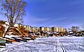
Frozen city pond in winter
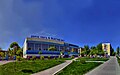
Sports palace of the AG Magnesit


economy
Satka is a magnesite mining and processing center . The AG Magnesit located here produces refractory materials on the basis of the raw material extracted from several open-cast mines .
There is also an important cast iron smelter as well as construction and wood industry companies.
sons and daughters of the town
- Vladimir Gundarzew (1944-2014), biathlete
Individual evidence
- ↑ a b Itogi Vserossijskoj perepisi naselenija 2010 goda. Tom 1. Čislennostʹ i razmeščenie naselenija (Results of the All-Russian Census 2010. Volume 1. Number and distribution of the population). Tables 5 , pp. 12-209; 11 , pp. 312–979 (download from the website of the Federal Service for State Statistics of the Russian Federation)
Web links
- City administration website (Russian)
- Satka on mojgorod.ru (Russian)
- Photos Satka (Russian)
| Cities |
Ascha R | Bakal | Jemanschelinsk R | Jurjusan | Yuzhnouralsk S | Karabash S | Kartaly R | Kasli R | Kataw-Ivanovsk R | Kopeisk S | Korkino R | Kussa R | Kyschtym S | Magnitogorsk S | Miass S | Minjar | Nyazepetrovsk R | Osjorsk S / G | Plast R | Satka R | Sim | Zlatoust S | Snezhinsk S / G | Trjochgorny S / G | Troitsk S / R | Chebarkul S / R | Chelyabinsk S | Ust-Kataw S | Verkhneuralsk R | Werchni Ufalei S. |
|
| Urban-type settlements |
Berdjausch | Yuzhny | Krasnogorski | Kropachovo | Lokomotiwny S / G | Magnitka | Meshevoi | Meshosjorny | Pervomaiski | Pink | Sauralski | Suleya | Vishnevogorsk |
|
| Other Rajon centers |
Agapowka | Argayash | Bredy | Dolgoderevenskoye | Ferschampenuas | Jetkul | Kisilskoye | Kunashak | Miasskoye | Oktyabrskoye | Chesma | Uiskoje | Uwelski | Varna |