
Spreeradweg
| Spreeradweg | |
|---|---|

|
|
| overall length | approx. 360 km |
| location |
|
| Starting point |
Source of the Spree near Ebersbach / Sa. 51 ° 0 ′ 30 " N , 14 ° 35 ′ 0" E |
| Target point |
Spree island near Berlin 52 ° 30 ′ 58 ″ N , 13 ° 24 ′ 8 ″ E |
| Places along the way |
|
| Flooring | mostly paved |
| Height difference | from approx. 350 m above sea level NN up to 34 m above sea level NN |
| difficulty | some difficult climbs before Bautzen , otherwise easy |
| Connection to | |
| Website URL | Spreeradweg |
.jpg)
The Spree Cycle Path runs for around 360 km from the sources of the Spree in Upper Lusatia to Berlin , where the Spree flows into the Havel .
Route
The cycle path begins at the source of the Spree in Eibau and follows the Spree run through the Lusatian mountains to Bautzen . This part of the route has many inclines. From Bautzen you drive through the Upper Lusatian heath and pond landscape and thus through a somewhat flatter area. We continue past the lignite mining area near Spremberg . After Cottbus follows Peitz pond area . The cycle path continues through the Spreewald with its widely branched canals. Then the river unites again and you can continue cycling via Fürstenwalde to Erkner on the Berlin city limits. There the Spreeradweg connects to the Europaradweg R1 .
In the Saxon part, the signage is partly in need of supplementation and maintenance. It is almost completely absent in the lignite follow-up landscape between Uhyst (Spree) and Schwarze Pumpe . From Ebersbach / Sa. The way to Bautzen is very well signposted. In the Upper Lusatian Heath and Pond Landscape Biosphere Reserve north of Bautzen, the Boxberg power plant is a dominant feature of the path that cannot be overlooked and leads safely to Uhyst. The way to Bärwalder See and the following left bypass to Bärwalde and Boxberg is signposted. Shortly before the Boxberg power plant, you reach Bundesstraße 156 and take the cycle path next to it to the power plant. In front of this, take the Spreestrasse, which leads off to the left of the power plant, on the left cycle path a few kilometers from the western part of the Oberlausitz military training area . The required junction to Döschko and Neustadt / Spree is signposted with "Döschko". At the Spreewitz junction , the direction Spremberg is signposted again. The entire route is partly varied and close to nature on good paths, partly primarily suitable for bridging distances.
There are various options along the way to spend the night or to have your bike repaired.
Sights en route
- Ebersbach / Sa .: Spree spring , half-timbered houses
- Sohland: Half-timbered houses, sky bridge , list of cultural monuments in Sohland on the Spree
- Schirgiswalde: half-timbered houses, churches, a Silbermann organ
- Großpostwitz: Protestant church
- Bautzen: Old town with old water art and St. Michael's Church
- Malschwitz: Upper Lusatian Heath and Pond Landscape Biosphere Reserve , Baroque Milkel Castle nearby
- Uhyst: Bärwalder See , New Castle
- Bärwalde: Castle
- Sprey: Schrotholzkirche
- Spreewitz: half-timbered church
- Spremberg: historical city center
- Bühlow: Spremberg dam
- Madlow: Branitzer Park , Kutzeburg Mill
- Castle: Spreewald Biosphere Reserve
- Lübben: Lübben Castle
- Schlepzig: Schlepzig village church
- Beeskow: Beeskow Castle
- Fürstenwalde: List of architectural monuments in Fürstenwalde / Spree
- Erkner: Gerhart Hauptmann Museum
- Köpenick: Köpenick Castle
- Karlshorst: List of cultural monuments in Berlin-Karlshorst
- Museum Island: State Museums in Berlin
photos

Source of the Spree in Ebersbach / Sa.

Half-timbered house in Ebersbach

Sky Bridge in Sohland

Catholic Church in Schirgiswalde

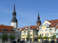
City view of Bautzen
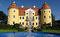
Front view of the Baroque Milkel Palace

Bärwalder See and the Boxberg power plant

Schrotholzkirche in Sprey
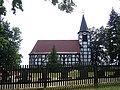
Half-timbered church in Spreewitz
Town hall and Kreuzkirche in Spremberg

Branitz Castle in Branitz Park

Lübbenau Castle
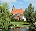
Marienkirche in Beeskow

Genezareth Church in Erkner

View of the Museum Island with the Bode Museum and Monbijou Bridge and the television tower in the background


.jpg)


.JPG)

See also
literature
- Bikeline bike tour book: Spree bike path. paperback, 8th edition June 2015, ISBN 3850000702 .
- Cycling map of the Spree cycle path. 1: 50,000, Verlag Dr. Barthel, Borsdorf, 3rd edition 2019, ISBN 978-3-89591-102-6 .
Web links
- The Spreeradweg, 356 km - from the source through the Spreewald to Berlin , on spreewald-info.de
- radwandern-oberlausitz.de , on radwandern-oberlausitz.de
- The Spreeradweg on the website of Tourismus-Marketing Brandenburg GmbH
- Spreeradweg [ID 12030] ( Memento from April 15, 2014 in the Internet Archive ) in the ADFC tour portal
- www.spreeradweg.de private page