Egstedt
|
Egstedt
City of Erfurt
|
|
|---|---|
| Coordinates: 50 ° 55 ′ 5 ″ N , 11 ° 3 ′ 18 ″ E | |
| Height : | 353 (330-375) m |
| Area : | 12.58 km² |
| Residents : | 512 (December 31, 2017) |
| Population density : | 41 inhabitants / km² |
| Incorporation : | July 1, 1994 |
| Postal code : | 99097 |
| Area code : | 0361 |
|
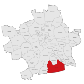
Location of Egstedt in Erfurt
|
|
Egstedt am Steiger is a district of the Thuringian capital Erfurt and is located 8 km south of the city center.
history

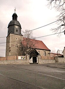
The region has been settled for a long time. Stone axes and hammers from the younger Stone Age were found in the Egstedter Flur, and an ax and a Kelt made from the metal that were common at the time from the Bronze Age . In the neighboring Waltersleben corridor, a burial ground of the band ceramists from the recent Bronze Age (around 1000 to 500 BC) was discovered. The name of the Egstedt church "St. Michael" points to a Germanic-pagan cult site that had previously existed there .
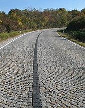
The place was on an old trade route from Erfurt south towards Stadtilm . The history of Egstedt has always been closely linked to that of Erfurt . Egstedt belonged to the city office of the Erfurt area . In armed conflicts, such as the Thirty Years' War, the Egstedt residents often fled to the protection of the Erfurt walls. In 1802 Egstedt came with the Erfurt area to Prussia and between 1807 and 1813 to the French principality of Erfurt . With the Congress of Vienna the place came back to Prussia in 1815 and in 1816 it was affiliated to the Erfurt district in the Prussian province of Saxony .
Ten men from Egstedt did not return from the First World War . The war memorial placed on them was removed in 1975 when the Rinnebach was piped up. The replica of the steel helmet on the memorial was removed beforehand.
Since the end of the 19th century there has been a military training area to the east of the village (today the military training area for the Bundeswehr). In a forest area between Egstedt and Schellroda there was an underground army ammunition facility during World War II (which was used by the NVA as "Muna" until 1990).
On April 11, 1945, US troops moved into Egstedt, the 3rd Battalion of the 318th Infantry Regiment of the 80th US Infantry Division. In the early morning there had been fighting in the Egstedter Flur. 16 Wehrmacht soldiers and one American were killed. Men from the village collected the dead on horse-drawn carts. They were buried in a row of tombs on April 15 in the Egstedt cemetery, next to the church. A memorial service was held in the church on April 29th. The US soldier was later transferred to the Margraten American Cemetery in the Netherlands. The tomb was also cared for by the community and residents during the GDR era.
Egstedt lost 18 men on the fronts and in captivity in World War II . The place was then part of the Soviet occupation zone from July 1945 , and the GDR from 1949 . Egstedt took part in the corresponding social developments. After many evacuees from the bomb-prone areas during the war, the place then had to accommodate numerous displaced persons . At the end of 1946 there were 200 such new citizens.
The residential area to the east, which began in the late 1980s, was expanded from the early 1990s. The building for the day care center and the community center were completed in 1991. The village club Egstedt e. V., the Heimatverein Egstedt e. V. and the parish of Egstedt essentially shape the cultural life in the village. There are two construction companies, two agricultural businesses and several craftsmen and traders in the village. Egstedt has many stately courtyards with restored half-timbered buildings, especially in the center. The former primary school was sold to private customers in 2009 and now includes a recording studio.
On March 14, 1974 Egstedt was enlarged by the previous municipality of Bechstedt-Wagd . On July 1, 1994 Egstedt was incorporated into the state capital Erfurt without Bechstedt-Wagd, while Bechstedt-Wagd was reclassified to Kirchheim the day before .
Population development
- 1843: 334
- 1910: 353
- 1939: 337
- 1990: 564
- 1995: 506
- 2000: 517
- 2005: 509
- 2010: 496
- 2011: 488
- 2012: 496
- 2013: 501
- 2014: 512
- 2015: 508
- 2017: 512
- 2018: 533
Place name
The village was already mentioned as Eggestat at the end of the 9th century . There are several interpretations for the place name. "Egge" is Old High German for "height", after which Egstedt would be "place on the height". In fact, at 350 meters, the place is the highest around Erfurt. Other interpretations are: "Eginstete" for "Schwertstätte" (Old High German "Egin" = sword) or designation after a name such as Eginald, Eginbert or Eginhard.
St. Michael Church
The church, which was consecrated to the Holy Trinity ( Trinity Church ) and whose patronage was originally due to the abbess of the Erfurt Cyriakskloster , was rebuilt in 1711 as a Protestant church. The lower part of the tower from earlier times was retained. The two bells were cast by the Ulrich brothers in Apolda . Next to a sandstone baptismal font of older origin, there is a baptismal frame from the time the church was rebuilt. A largely original Volcklandt organ on the upper gallery is worth seeing . However, it is no longer playable and requires extensive restoration. Since 2006, the “Church renovation project” has been restoring the valuable interior of the church by the parish council, committed citizens and with the support of the Association for the Preservation of Monuments in Thuringia as well as both local associations and individual donors. Up to 2010 the barrel vault, the galleries and the altar were renovated or restored. The aim was to "let the church shine in its old splendor again" for its 300th anniversary in 2011. The completion is still ongoing. In 2017, the enclosure of the church premises was extensively renovated through a private initiative and in-house.
coat of arms
The formerly independent municipality of Egstedt received official approval from the Thuringian Ministry of the Interior on June 27, 1994 to use a coat of arms.
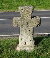
In this coat of arms, the harrow stands as an eloquent symbol for the folk etymological interpretation of the place name and for the relationship with agriculture that still exists today. The silver six-spoke wheel on a red background represents the historical trade route from Erfurt to Stadtilm and Egstedt's relationship with Erfurt. The black cross symbolizes the local church and at the same time indicates an atonement cross in the local area.
traffic
Egstedt is on the road from Erfurt to Stadtilm (which has existed since 1837).
A wide cycle path next to the busy route to Erfurt was built in 2011.
Events
- May fire
- Summer festival of the parish
- Fair
- Autumn fire
- Advent market
- Seniors Christmas party
Attractions
- Ev. Church of St. Michael and the surrounding cemetery with soldiers' graves
- former rectory
- Half-timbered houses
- Atonement cross made of sandstone in the shape of a Maltese cross: on the northern edge of the village on the right on the road to Erfurt
- Forsthaus Willrode in the Willroder forest east of the village.
- Kaiserwiese : this natural monument in Bechstedter and Rockhäuser Holz is the location of local orchids and the wild meadow gladiolus, which is threatened with extinction . From 1945 to 1950, the Soviet Air Force dropped bombs here for training purposes. Bomb craters can still be found in the area .

partnership
Since 1990 with Heidesheim am Rhein . A partnership between the Protestant parishes has existed since 1975
Personalities
- Johann Christoph Weingärtner (1771–1833), mathematician, clergyman and theologian, was pastor of Egstedt from 1805 to 1812
- Hermann Reinholz (* 1924 in Egstedt, † 1967 in Saarburg): lawyer and politician (CDU / West)
literature
- Egstedt. The history of our village . Author of the first part (until 1932): Pastor August Nebe. Author of the 2nd part (1933 to 2006): Rosi Lünser and Dieter Lünser. Self-published, 2008
Web links
- Page about Egstedt on the website of the city of Erfurt
- Steffen Raßloff : To the atonement cross for a murder near Erfurt in 1323 . In: Thüringer Allgemeine from September 1, 2012
Individual evidence
- ↑ Jürgen Möller (military historian, Ansbach): The end of the war in Thuringia . Manuscript, 2000. Quoted from research by Herbert Daniel, Erfurt, 2006
- ^ Herbert Daniel: The soldiers' graves from Egstedt 1945 . Private printing, Erfurt 2006
- ↑ Buresch, Anja: Battle for Erfurt. The American occupation of the city in April 1945. Erfurt 2016. ISBN 3954007185 .
- ^ Handbook of the Province of Saxony. Magdeburg, 1843.
- ↑ gemeindeververzeichnis.de
- ↑ Michael Rademacher: German administrative history from the unification of the empire in 1871 to the reunification in 1990. (Online material for the dissertation, Osnabrück 2006).
- ^ Thuringian State Office for Environment and Geology: Environment regional.
- ↑ Population of the city districts
- ↑ Population of the city districts
- ↑ Population of the city districts
- ^ August Nebe: Egstedt. The history of our village . Edited by Rosi Lünser, 2008, p. 2


