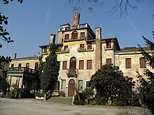
Stanghella
| Stanghella | ||
|---|---|---|

|
|
|
| Country | Italy | |
| region | Veneto | |
| province | Padua (PD) | |
| Coordinates | 45 ° 8 ′ N , 11 ° 45 ′ E | |
| height | 7 m slm | |
| surface | 19.69 km² | |
| Residents | 4,134 (Dec. 31, 2019) | |
| Population density | 210 inhabitants / km² | |
| Post Code | 35048 | |
| prefix | 0425, 0429 | |
| ISTAT number | 028088 | |
| Popular name | Stanghellesi | |
| Patron saint | Catherine of Alexandria | |
| Website | Stanghella | |
Stanghella is a north-eastern Italian municipality ( comune ) with 4134 inhabitants (as of December 31, 2019) in the province of Padua in Veneto . The municipality is located about 32 kilometers south-southwest of Padua and about 7.5 kilometers north-northwest of Rovigo on the Tramezzo canal , which runs roughly parallel to the Adige .
Parish partnership
traffic
The Strada Statale 16 Adriatica leads through Stanghella from Padua towards Ferrara and the Adriatic coast. The A13 autostrada also comes from Padua and continues to Bologna . Stanghella train station is on the Padua – Bologna line .
swell
- ↑ Statistiche demografiche ISTAT. Monthly population statistics of the Istituto Nazionale di Statistica , as of December 31 of 2019.
Web links
Commons : Stanghella - collection of images, videos and audio files


