
Autostrada A13
| Autostrada A13 in Italy | |||||||||||||||||||||||||||||||||||||||||||||||||||||||||||||||||||||||||||||||||||||||||||||||||||||||||||||||||||||||||||||||||||||||||||||||||
| Autostrada Bologna - Padova | |||||||||||||||||||||||||||||||||||||||||||||||||||||||||||||||||||||||||||||||||||||||||||||||||||||||||||||||||||||||||||||||||||||||||||||||||

|
|||||||||||||||||||||||||||||||||||||||||||||||||||||||||||||||||||||||||||||||||||||||||||||||||||||||||||||||||||||||||||||||||||||||||||||||||
| map | |||||||||||||||||||||||||||||||||||||||||||||||||||||||||||||||||||||||||||||||||||||||||||||||||||||||||||||||||||||||||||||||||||||||||||||||||
 |
|||||||||||||||||||||||||||||||||||||||||||||||||||||||||||||||||||||||||||||||||||||||||||||||||||||||||||||||||||||||||||||||||||||||||||||||||
| Basic data | |||||||||||||||||||||||||||||||||||||||||||||||||||||||||||||||||||||||||||||||||||||||||||||||||||||||||||||||||||||||||||||||||||||||||||||||||
| Operator: | |||||||||||||||||||||||||||||||||||||||||||||||||||||||||||||||||||||||||||||||||||||||||||||||||||||||||||||||||||||||||||||||||||||||||||||||||
| Start of the street: |
Bologna ( 44 ° 32 ′ N , 11 ° 22 ′ E ) |
||||||||||||||||||||||||||||||||||||||||||||||||||||||||||||||||||||||||||||||||||||||||||||||||||||||||||||||||||||||||||||||||||||||||||||||||
| End of street: |
Vigonza ( 45 ° 25 ′ N , 11 ° 57 ′ E ) |
||||||||||||||||||||||||||||||||||||||||||||||||||||||||||||||||||||||||||||||||||||||||||||||||||||||||||||||||||||||||||||||||||||||||||||||||
| Overall length: | 116.7 km | ||||||||||||||||||||||||||||||||||||||||||||||||||||||||||||||||||||||||||||||||||||||||||||||||||||||||||||||||||||||||||||||||||||||||||||||||
|
Regions : |
|||||||||||||||||||||||||||||||||||||||||||||||||||||||||||||||||||||||||||||||||||||||||||||||||||||||||||||||||||||||||||||||||||||||||||||||||
| Requirement for use: | Toll obligation: closed system | ||||||||||||||||||||||||||||||||||||||||||||||||||||||||||||||||||||||||||||||||||||||||||||||||||||||||||||||||||||||||||||||||||||||||||||||||
| Development condition: | 2 × 2 lanes | ||||||||||||||||||||||||||||||||||||||||||||||||||||||||||||||||||||||||||||||||||||||||||||||||||||||||||||||||||||||||||||||||||||||||||||||||
 |
|||||||||||||||||||||||||||||||||||||||||||||||||||||||||||||||||||||||||||||||||||||||||||||||||||||||||||||||||||||||||||||||||||||||||||||||||
| An LED sign on the A13 | |||||||||||||||||||||||||||||||||||||||||||||||||||||||||||||||||||||||||||||||||||||||||||||||||||||||||||||||||||||||||||||||||||||||||||||||||
|
Course of the road
|
|||||||||||||||||||||||||||||||||||||||||||||||||||||||||||||||||||||||||||||||||||||||||||||||||||||||||||||||||||||||||||||||||||||||||||||||||
The Autostrada A13 ( Italian for 'Motorway A13') is an Italian motorway in the north of the country that connects Bologna with Padua . It is 116.7 km long and requires a toll . It runs between the two regions of Veneto and Emilia-Romagna . The motorway is operated by the operating company Autostrade per l'Italia .
Route

The entire stretch of the A13 is in the Po Valley . It connects the industrial centers of Padua and Bologna with each other and represents a connection between the north-east and the center of Italy . The A13 begins in Bologna, where it branches off from the Tangenziale, which in Bologna form the A1 and the A14 . Heading north, it leads past Bologna Airport to the provincial capital of Ferrara , where the RA08 Ferrara - Porto Garibaldi motorway joins the A13. At km 40 the Po is crossed, which also forms the border between Emilia-Romagna and Veneto. The motorway then passes the provincial capital Rovigo and the Euganean Hills . In the south of the city of Padua, in the junction Padova-Sud there are connections to tangenziale of Padua. In its last section, it passes east of the city and then joins the A4 .
Opening and development status
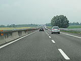
The entire length of the motorway was opened to traffic on June 6, 1970. The entire motorway is four lanes and provided with hard shoulder.
plans
The expansion plans for Autostrade per l'Italia , which were decided in 2008, also include a six-lane expansion between Bologna and Padua. The Padova Sud and Monselice section of 13.3 km and the Ferrara - Bologna section of 32.7 km are to be expanded to six lanes (3 lanes in each direction).
Tutor and fog signals
The A13 was selected together with the A4 and A14 motorways to test the new Tutor system . Here, it is not the speed at a specific location that is measured, but the average speed over a longer distance ( comparable to the Section Control used in Austria ).
This affects the sections between the Occiobello and Archoveggio junctions near Bologna and between Rovigo and Padova-Zona Industriale.
The section of the A13 leads through an area that is very often affected by ground fog in winter , which is why it is equipped with white semicircles on the side of the motorway in large sections to provide visual aid in fog.
gallery
The motorway at Rovigo
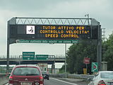
Notice on the A13 that Tutor is activated

Reference to the fog signals on the edge of the motorway


Motorway junction Padova sud
| Autostrada A13 in Italy | ||||||||||||||||||||||||||||||||||
| Diramazione Padova sud (Junction Padova sud) |
||||||||||||||||||||||||||||||||||
|
|
||||||||||||||||||||||||||||||||||
| Basic data | ||||||||||||||||||||||||||||||||||
| Operator: | ||||||||||||||||||||||||||||||||||
| Start of the street: |
Albignasego ( 45 ° 20 ′ N , 11 ° 51 ′ E ) |
|||||||||||||||||||||||||||||||||
| End of street: |
Albignasego ( 45 ° 22 ′ N , 11 ° 51 ′ E ) |
|||||||||||||||||||||||||||||||||
| Overall length: | 4.3 km | |||||||||||||||||||||||||||||||||
|
Regions : |
||||||||||||||||||||||||||||||||||
| Requirement for use: | toll-free | |||||||||||||||||||||||||||||||||
| Development condition: | 2 × 2 lanes | |||||||||||||||||||||||||||||||||
|
Course of the road
|
||||||||||||||||||||||||||||||||||
This motorway slip road connects the A13 to the urban transport network of Padua. It is 4.3 km long and does not require a toll.
It has four lanes (2 lanes in each direction) including hard shoulder.
Another name for the motorway branch is D13
Motorway junction to Ferrara
| Autostrada A13 in Italy | ||||||||||||||||||||||||||||
| Diramazione per Ferrara (Junction Ferrara) |
||||||||||||||||||||||||||||
|
|
||||||||||||||||||||||||||||
| Basic data | ||||||||||||||||||||||||||||
| Operator: | ||||||||||||||||||||||||||||
| Start of the street: |
Ferrara ( 44 ° 48 ′ N , 11 ° 33 ′ E ) |
|||||||||||||||||||||||||||
| End of street: |
Ferrara ( 44 ° 48 ′ N , 11 ° 38 ′ E ) |
|||||||||||||||||||||||||||
| Overall length: | 6.3 km | |||||||||||||||||||||||||||
|
Regions : |
||||||||||||||||||||||||||||
| Requirement for use: | toll-free | |||||||||||||||||||||||||||
| Development condition: | 2 × 2 lanes | |||||||||||||||||||||||||||
|
Course of the road
|
||||||||||||||||||||||||||||
The junction to Ferrara is 6.3 km long and originates at the junction with the A13. It merges onto the RA8 motorway for another 49 km towards Porto Garibaldi.
It was opened to traffic on December 22, 1966.
This junction is classified internally within Autostrade per l'Italia as D23 .
There is a project for an extension to the Rolo - Reggiolo exit on the A22 motorway to the west through the construction of the Cispadana regional motorway.
Web links
Individual evidence
- ^ Structures along the A13
- ↑ Opening dates of the A13
- ↑ Planned projects
- ↑ Information on the Tutor project ( Memento of the original from August 16, 2012 in the Internet Archive ) Info: The archive link was inserted automatically and has not yet been checked. Please check the original and archive link according to the instructions and then remove this notice.
- ↑ a b teonline.autostrade.it
| Motorways (Autostrade) |
A 1 • A 2 • A 3 • A 4 • A 5 • A 6 • A 7 • A 8 • A 9 • A 10 • A 11 • A 12 • A 13 • A 14 • A 15 • A 16 • A 18 • A 19 • A 20 • A 21 • A 22 • A 23 • A 24 • A 25 • A 26 • A 27 • A 28 • A 29 • A 30 • A 31 • A 32 • A 33 • A 34 • A 35 • A 36 • A 91 • Catania – Siracusa • Sistiana – Rabuiese • Pedemontana Veneta |
|
|
City bypasses (tangents) (Autostrade tangenziali) |
A 50 • A 51 • A 52 • A 53 • A 54 • A 55 • A 56 • A 57 • A 58 • A 59 • A 60 • A 90 / GRA |
|
|
Motorway junctions (Diramazioni autostradali) |
A 1dir • A 1var • A 2dirNA • A 2dirRC • A 4 / A 5 • A 8 / A 26 • A 11 / A 12 • A 14dir • A 18dir • A 19dir • A 21dir • A 21racc • A 26 / A 4 • A 26 / A 7 • A 29dir • A 29dirA • A 29racc • A 29racc to |
|
|
Motorway feeder (Raccordi autostradali) |
RA 1 • RA 2 • RA 3 • RA 4 • RA 5 • RA 6 • RA 8 • RA 9 • RA 10 • RA 11 • RA 12 • RA 13 • RA 14 • RA 15 • RA 16 |
|
|
Tunnel highways (Trafori) |
||
| Highways in planning |
Regional Cispadana • Nogara - Mare • Venezia - Roma • Roma - Latina |
|
| rededicated routes |
