
Chertkovo (Rostov)
| settlement
Chertkovo
Чertково
|
||||||||||||||||||||||||||||
|
||||||||||||||||||||||||||||
|
||||||||||||||||||||||||||||
| List of large settlements in Russia | ||||||||||||||||||||||||||||
.svg)

Tschertkowo ( Russian Чертко́во ) is a settlement (possjolok) in the Rostov Oblast in Russia with 10,814 inhabitants (as of October 14, 2010).
geography
The place is just 250 km as the crow flies north of the Rostov-on-Don Oblast Administrative Center directly on the state border with Ukraine . Across the border is the urban-type Milowe (Russian Melowoje ) settlement . The Melowaya flows north of the settlement and flows 8 km east into the Kalitwa , a left tributary of the Seversky Donets .
Tschertkowo is the administrative center of the Tschertkowski Rajons and the seat of the rural municipality of Tschertkowskoje selskoje posselenije, which also includes the hamlet (chutor) Poltava (2 km northeast).

District administration

Chertkovo Railway Station (1895)
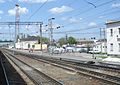
Chertkovo Railway Station (2012)
.jpg)


history
The place was created in connection with the construction of the Voronezh - Rostov-on-Don railway line from 1869, which began operations there in 1871. The train station and the associated settlement on the border of the then Oblast of the Don Army (Oblast Woiska Donskowo) and the Charkow governorate were named after the ataman of the Don Cossacks , General Michail Tschertkow (1829-1905).
On January 10, 1934, Chertkowo became the administrative seat of a Rajon, which was also named after him, after it had existed since 1924 as Leono-Kalitwinski rajon with its center in Sloboda Mankowo-Kalitvenskaya , a few kilometers to the east . From 1929 to 1993 Chertkovo had the status of an urban-type settlement.
Population development
| year | Residents |
|---|---|
| 1939 | 6,498 |
| 1959 | 9,104 |
| 1970 | 9,399 |
| 1979 | 11.303 |
| 1989 | 10,751 |
| 2002 | 11,029 |
| 2010 | 10,814 |
Note: census data
traffic
Chertkovo is located on the since 1963 on this section electrified railway Moscow - Voronezh - Rostov (kilometer 900), the main rail link today between Central Russia and the Caucasus and the Black Sea coast . Around Chertkowo, the route runs in several sections directly along the Russian-Ukrainian border; north of the station ends the section operated by the North Caucasian Railway , which is followed by the Southeast Railway .
The settlement is connected by the regional road 60K-317 to the federal highway M4 Don Moscow - Rostov-on-Don - Novorossiysk , which runs 30 km to the east . There is a road border crossing in the village only for citizens of Russia and Ukraine; across the border, the road continues as the R-07 in the direction of Starobilsk - Kupyansk .
Web links
Individual evidence
- ↑ a b Itogi Vserossijskoj perepisi naselenija 2010 goda. Tom 1. Čislennostʹ i razmeščenie naselenija (Results of the All-Russian Census 2010. Volume 1. Number and distribution of the population). Tables 5 , pp. 12-209; 11 , pp. 312–979 (download from the website of the Federal Service for State Statistics of the Russian Federation)
| Cities |
Aksai R | Azov S / R | Bataisk S | Belaya Kalitwa R | Donetsk S | Gukowo S | Kamensk-Shakhtinsky S | Konstantinovsk R | Krasny Sulin R | Millerowo R | Morozovsk R | Novoshakhtinsk S | Novocherkassk S | Proletarsk R | Rostov-on-Don S | Salsk R | Schachty S | Semikarakorsk R | Sernograd R | Swerewo S | Taganrog S | Volgodonsk S | Zimlyansk R |
|
| Urban-type settlements |
Gluboki R | Gorny | Kamenolomni R | Schirnow | Scholochowski | Uglerodowski | Ust-Donetsky R |
|
| Other Rajon centers |
Bagayevskaya | Bokovskaya | Bolshaya Martynovka | Dubovskoye | Egorlykskaya | Kagalnitskaya | Kazanskaya | Kaschary | Kuibyshevo | Matveev Kurgan | Milyutinskaya | Oblivskaya | Orlowski | Pestschanokopskoye | Pokrovskoye | Remontnoye | Rodionovo-Nesvetaiskaya | Romanovskaya | Sawetnoye | Simovniki | Sovetskaya | Tarassowski | Tatsinskaya | Tschaltyr | Chertkovo | Vessyoly | Vyoschenskaya | Zelina |