
Vrbno pod Pradědem
| Vrbno pod Pradědem | |||||
|---|---|---|---|---|---|
|
|||||
| Basic data | |||||
| State : |
|
||||
| Region : | Moravskoslezský kraj | ||||
| District : | Bruntál | ||||
| Area : | 6891 ha | ||||
| Geographic location : | 50 ° 7 ' N , 17 ° 23' E | ||||
| Height: | 545 m nm | ||||
| Residents : | 5,040 (Jan 1, 2019) | ||||
| Postal code : | 793 26 | ||||
| traffic | |||||
| Railway connection: | Milotice nad Opavou – Vrbno pod Pradědem | ||||
| structure | |||||
| Status: | city | ||||
| Districts: | 5 | ||||
| administration | |||||
| Mayor : | Petr Kopínec (as of 2019) | ||||
| Address: | Nádražní 389 793 26 Vrbno p. Pradědem |
||||
| Municipality number: | 597961 | ||||
| Website : | www.vrbnopp.cz | ||||


Vrbno pod Pradědem (German Würbenthal ) is a town in the Czech town of Okres Bruntál ( Freudenthal district ). It is attached to the Vrbensko microregion.
geography

The city is located in the Sudetes in the Jeseníky Mountains , about 25 kilometers west of Krnov ( hunting village ) and twelve kilometers northeast of the Jeseníky . In the basin north of the city, the oppa is formed from the confluence of its source rivers, the black , white and middle oppa . To the west of the city on the Burgberg are the remains of Fürstenwalde Castle . The health resort Karlova Studánka ( Bad Karlsbrunn ) is located nine kilometers southwest of the city .
history
The first known settlement dates from the 13th century. The place was expanded by Heinrich von Würben to a town with 200 houses and on June 24, 1611 he raised it to town. Würbenthal came into the possession of the Teutonic Order while he was still alive .
On December 5, 1880, the town received a rail connection from the Ebersdorf – Würbenthal state railway . At the beginning of the 20th century, Würbenthal had factories for metal goods, glass, flax spinning , thread production , jute spinning and jute weaving and was the seat of a district court.
Through the Munich Agreement in 1938 Würbenthal was assigned to the German Reich together with the Sudetenland ; until 1945 the city belonged to the district of Freudenthal , district of Troppau , in the Reichsgau Sudetenland .
After the Second World War , the German population was expropriated and expelled in 1945 .
Demographics
| year | Residents | Remarks |
|---|---|---|
| 1834 | 1,359 | German residents |
| 1900 | 3.113 | German residents |
| 1910 | 3,614 | 3,293 Catholics, 307 Protestants and three Israelites |
| 1930 | 3,984 | |
| 1939 | 4.029 |
On May 22, 1947, Würbenthal had 2,327 residents.
mayor
- 1882 to 1905 Emil Grohmann
- 1905 to 1909 Hugo Grohmann (the last honorary citizen of Würbenthal)
- 1909 to 1912 Karl Schittenhelm
- 1912 to 1920 Josef Nitsch
- 1920 to 1930 Rudolf Ulrich
- 1930 to 1934 Otto König
- 1934 to 1938 Josef Thiel
- 1938 to 1945 Emil Zöllner
- currently: Helena Kudelova
City structure
The town of Vrbno pod Pradědem includes the districts Bílý Potok ( Weissbach ), Mnichov ( Einsiedel ), Vidly ( fork ) and Železná ( Buchbergsthal ).
The Einsiedel district had 2,214 inhabitants on December 1, 1930, 2,100 on May 17, 1939 and 788 on May 22, 1947.
The district of Buchbergsthal had 828 inhabitants on December 1, 1930, 800 on May 17, 1939 and 524 on May 22, 1947.

Residence of the Grohmann family of industrialists

Villa Frieda Grohmann

Villa Adolf Grohmann

chapel

Michaelskirche
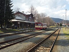
railway station

_2.JPG)
.JPG)
_2.JPG)


Twin cities
- Głogówek , Poland
- Sindelfingen , Germany
Sons and daughters of the place
- Josef Lowag (1849–1911), Sudeten Silesian dialect poet
- Hermann Heß (1897–1948), writer and poet
- Johann Karl Nestler (1783–1841), agricultural scientist
- Adolf Grohmann (1825–1895), entrepreneur
- Robert Grohmann (1854–1907), industrialist, son of Adolf Grohmann
- Marianne Strobl (1865–1917), photographer
literature
- Faustin Ens : The Oppaland, or the Troppauer Kreis, according to its historical, natural history, civil and local characteristics . Volume 3: Description of the Oppaland and its inhabitants in general . Gerold, Vienna 1836, pp. 196–199 and p. 240
- Othmar Kloske: Chronicle of Würbenthal (contribution to the 300 year city anniversary 1611-1911). Würbenthal 1911 self-published by the author.
- Spolek Přátel Vrbenska: Vrbno pod Pradědem - Ohlédnutí za minulostí dávnou i nedávnou . 2011.
- Jan Šícha, Eva Habel, Peter Liebald, Gudrun Heissig: Odsun. The expulsion of the Sudeten Germans. Documentation on the causes, planning and realization of an "ethnic cleansing" in the middle of Europe in 1945/46. Sudeten German Archive, Munich 1995, ISBN 3-930626-08-X .
Web links
Individual evidence
- ↑ Český statistický úřad - The population of the Czech municipalities as of January 1, 2019 (PDF; 7.4 MiB)
- ↑ Faustin Ens : The Oppaland or the Opava district, according to its historical, natural history, civic and local peculiarities . Volume 3: Description of the Oppaland and its inhabitants in general . Gerold, Vienna 1836, pp. 196–199 .
- ↑ a b Würbenthal . In: Meyers Großes Konversations-Lexikon . 6th edition. Volume 20, Bibliographisches Institut, Leipzig / Vienna 1909, p. 771 .
- ↑ Faustin Ens : The Oppaland or the Opava district, according to its historical, natural history, civic and local peculiarities . Volume 3: Description of the Oppaland and its inhabitants in general . Gerold, Vienna 1836, p. 240 .
- ↑ Ludwig Patryn (Ed.): The results of the census of December 31, 1910 in Schlesien , Opava 1912, pp. 38-39.
- ↑ a b Michael Rademacher: German administrative history from the unification of the empire in 1871 to the reunification in 1990. Freudenthal district (Czech Bruntál). (Online material for the dissertation, Osnabrück 2006).