Horní Bradlo: Difference between revisions
Content deleted Content added
m →External links: WP:CHECKWIKI error fixes / special characters in sortkey fixed using AWB (9427) |
m Robot: Include commonscat template |
||
| Line 12: | Line 12: | ||
{{DEFAULTSORT:Horni Bradlo}} |
{{DEFAULTSORT:Horni Bradlo}} |
||
| ⚫ | |||
[[Category:Chrudim District]] |
[[Category:Chrudim District]] |
||
[[Category:Villages in the Czech Republic]] |
[[Category:Villages in the Czech Republic]] |
||
| ⚫ | |||
Revision as of 16:25, 16 November 2013

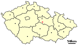
Horní Bradlo is a small village in the Pardubice Region of the Czech Republic. It has around 470 inhabitants.
Hamlets Dolní Bradlo, Javorné, Lipka, Travná, Velká Střítež and Vršov are administrative parts of Horní Bradlo.
External links
- Official site (cz)
49°48′N 15°45′E / 49.800°N 15.750°E
Wikimedia Commons has media related to Horní Bradlo.
