
Zádveřice-Raková: Difference between revisions
Content deleted Content added
m fix |
m →References: add authority control |
||
| Line 40: | Line 40: | ||
{{Zlín District}} |
{{Zlín District}} |
||
{{authority control}} |
|||
{{DEFAULTSORT:Zadverice Rakova}} |
{{DEFAULTSORT:Zadverice Rakova}} |
||
Revision as of 01:50, 2 April 2020
Zádveřice-Raková | |
|---|---|
Municipality | |
 Zádveřice | |
 Flag  Coat of arms | |
 Zádveřice-Raková | |
| Coordinates: 49°12′53″N 17°48′41″E / 49.21472°N 17.81139°E | |
| Country | |
| Region | Zlín |
| District | Zlín |
| Area | |
| • Total | 17.96 km2 (6.93 sq mi) |
| Elevation | 264 m (866 ft) |
| Population (2006) | |
| • Total | 1,341 |
| • Density | 75/km2 (190/sq mi) |
| Postal code | 763 12 |
| Website | http://www.zadverice.cz |
Zádveřice-Raková is a village and municipality (obec) in Zlín District in the Zlín Region of the Czech Republic.
The municipality covers an area of 17.96 square kilometres (6.93 sq mi), and has a population of 1,341 (as at 3 July 2006).
Zádveřice-Raková lies approximately 11 kilometres (7 mi) east of Zlín and 263 km (163 mi) east of Prague.
Gallery
-
 Municipal office and the fire brigade
 -
 Restaurant
 -
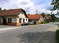
 Local part Raková
 -
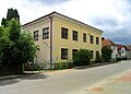 Old school building


References
Wikimedia Commons has media related to Zádveřice-Raková.
| Authority control databases: National |
|---|
This Zlín Region location article is a stub. You can help Wikipedia by expanding it. |