Tečovice
| Tečovice | ||||
|---|---|---|---|---|
|
||||
| Basic data | ||||
| State : |
|
|||
| Region : | Zlínský kraj | |||
| District : | Zlín | |||
| Area : | 666 ha | |||
| Geographic location : | 49 ° 13 ' N , 17 ° 35' E | |||
| Height: | 208 m nm | |||
| Residents : | 1,334 (Jan 1, 2019) | |||
| Postal code : | 763 02 | |||
| License plate : | Z | |||
| traffic | ||||
| Street: | Zlín - Mysločovice | |||
| Railway connection: | Otrokovice - Vizovice | |||
| structure | ||||
| Status: | local community | |||
| Districts: | 1 | |||
| administration | ||||
| Mayor : | Jaromír Doležal (as of 2011) | |||
| Address: | Tečovice 185 763 02 Zlín 4 |
|||
| Municipality number: | 549649 | |||
| Website : | www.tecovice.cz | |||
Tečovice (German Tetschowitz ) is a municipality in the Czech Republic . It is located six kilometers west of Zlín and belongs to the Okres Zlín .
geography
Tečovice is located in the western foothills of the Vizovice highlands at the transition to the Upper Moravian Depression ( Hornomoravský úval ). The village extends on the right side of the Dřevnice along its tributary Hostišovka. The Vinohrádky (301 m) rise to the north, the Díl (273 m) to the east, the Tlustá hora (458 m) and the Šternberk (345 m) to the south-east and the Havránkov (252 m) to the north-west. To the west of the village lies the Racková valley. To the north there is a sports airfield on the Vinohrádky. To the south, the Otrokovice - Vizovice railway runs through the Dřevnice valley; the nearest train station, Zlín-Malenovice, is one and a half kilometers from Tečovice.
Neighboring towns are Lhotka in the north, Chlum in the northeast, Prštné and Louky in the east, U Majáku and Březnice in the southeast, Malenovice in the south, Kvítkovice and Otrokovice in the southwest, Bahňák in the west and Buňov and Sazovice in the northwest.
history
Archaeological finds show a settlement in the municipality since the Paleolithic . The first written mention of the place Cetisouicih took place in 1141 in a property register of the Olomouc bishop Heinrich Zdik among the goods of the Archdiocese of Přerov . At the transition from the 12th to the 13th century there was a fortified settlement on the site of the church, protected by ramparts. The next documented tradition dates from 1307. At that time, Teczowicze formed an independent estate, owned by Vladike Buň from Tečovice. Next to the feast of the Lords of Tečovice there was a little church, which, according to archaeological findings, was built around 1260. In the course of the union of the Tečovice and Malenovice dominions, Teczowicze became subject to the Malenovice Castle in 1350 and the Tečovice Fortress was extinguished at the end of the 14th century. In 1356 the place was called Tetcowycz . The work of the priest Milicz de Teczowicz (1320-1374, Milíč z Tečovic ), who later went to Kremsier and worked there as a preacher under the name of Iohannis Milicii de Cremsier , also fell into this period . The owners of the estate changed many times. On August 11, 1470, King George of Podebrady camped in Tetczowicz during the Bohemian-Hungarian War . The place name Tetczowicze has been handed down from 1492 . The lords of Liechtenstein-Kastelkorn were among the most important owners of the estate . Until the middle of the 19th century, the place was always subject to Malenovice.
After the abolition of patrimonial Tetšovice / Tetschowitz formed from 1850 a municipality in the district administration Uherské Hradiště . From 1881 the village was called Cetišovice , the current place name Tečovice was introduced in 1924. When the Okres Zlín was established in 1935, the municipality was assigned to it. Tečovice was incorporated into Gottwaldov in 1960 and broke away on November 24, 1990 from the town, which in the meantime was renamed Zlín again.
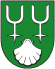
The municipality has had a coat of arms and a banner since 1992. It shows two silver spurs on a green field , which symbolize the Vladiken von Tečovice. The shell refers to the local saint and church patron.
Local division
No districts are shown for the municipality of Tečovice.
Attractions
- Gothic church Jakobus the Elder, at the upper end of the town, it was built around 1260 and was redesigned in the baroque style in the second half of the 17th century. The ornate portal can be assigned to the construction works of the Cistercian monastery Velehrad . The church is surrounded by a walled cemetery.
- Stone cross in the cemetery, created in 1746 as a gift from a Polish hussar
- Baroque statue of St. Valentin from the middle of the 18th century, at the church
- Path chapel on the road to Sazovice, built in the 18th century
- 600-year-old linden tree in the Noviny corridor below the chapel

