Mysločovice
| Mysločovice | ||||
|---|---|---|---|---|
|
||||
| Basic data | ||||
| State : |
|
|||
| Region : | Zlínský kraj | |||
| District : | Zlín | |||
| Area : | 366 ha | |||
| Geographic location : | 49 ° 15 ' N , 17 ° 34' E | |||
| Height: | 212 m nm | |||
| Residents : | 625 (Jan. 1, 2019) | |||
| Postal code : | 763 01 | |||
| License plate : | Z | |||
| traffic | ||||
| Street: | Machová - Lechotice | |||
| structure | ||||
| Status: | local community | |||
| Districts: | 1 | |||
| administration | ||||
| Mayor : | Pavel Žák (as of 2010) | |||
| Address: | Mysločovice 21 763 01 Mysločovice |
|||
| Municipality number: | 585505 | |||
| Website : | myslocovice.cz | |||
Mysločovice (German Misloschowitz , formerly Misloczowitz ) is a municipality in the Czech Republic . It is located eight kilometers northwest of Zlín and belongs to the Okres Zlín .
geography
Mysločovice is located in the western foothills of the Wisowitz Mountains at the transition to the Upper Moravian Depression ( Hornomoravský úval ). The village extends to the right of the Racková brook at the confluence of the Míškovický potok. To the north rises the Široky (245 m), to the east the Holý kopec (313 m), the Skála (344 m) and the Hřeben (399 m), to the south-east the Háj (285 m) and the Vinohrádky (301 m), im The Korbele (281 m) to the southwest and the Křemenná (314 m) to the northwest.
Neighboring towns are Na Kopci and Zahnašovice in the north, Lechotice , Strhanec and Racková in the northeast, Hostišová in the east, Zbožensko, Chlum and Lhotka in the southeast, Sazovice in the south, Terezov and Bahňák in the southwest, Machová in the west and Záhlinice and Míškovice in the northwest.
history
The first written mention of the village Mysloczowicze belonging to the Količín rule, including the church, came in 1397 when, after the death of Peter Holický von Sternberg, his heirs Peter von Krawarn and Marquart von Sternberg built the Količín Castle with the villages Blazice , Hostišová , Količín, Lechotice , Machová , Markov, Meziříčí, Míškovice , Mysloczowicze , Racková , Sazovice , Siročý and Žeranovice to the brothers Zdenko and Jesko Lukovský von Sternberg. The subsequent owners included the gentlemen von Sazowitz and von Morkowitz. In 1446 Albert von Sternberg acquired Mysloczowicze and added it to his rule Holešov . In 1588, Charles the Elder from Zerotein became the owner of Holešov, and at the beginning of the 17th century the Lobkowicz boogers followed . In 1650 Johann von Rottal acquired the rule. After the von Rottal family had died out , the Counts of Würben inherited the rule in 1762 . Until the middle of the 19th century, the place remained subservient to Holešov.
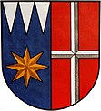
After the abolition of patrimonial Mysloczowicz formed from 1850 a municipality in the district authority Holešov. The residents lived mainly from agriculture. The current place name Mysločovice has been used since 1872. The volunteer fire brigade was founded in 1893. Between 1880 and 1910 the municipality was called Myslošovice . From 1950 Mysločovice belonged to the Okres Gottwaldov-okolí and from 1960 to the Okres Gottwaldov , which has been called Okres Zlín again since 1990. Between 1961 and 1968 Mysločovice was merged with Machová to form a municipality Mysločovice-Machová . Since February 25, 2003 the community has had a coat of arms and a banner. It symbolizes the pointed star of the Lords of Sternberg, with the silver cross on a red field the coat of arms of the Lords of Rottal as well as with three silver cones on a blue field the diocese of Olomouc and St. Trinity.
Local division
No districts are shown for the municipality of Mysločovice.
Attractions
- Church of St. Trinity, built 1752–1758 by the builder Thomas Sturm in place of the old church from 1397, Franz Anton von Rottal and Vicar General Count Egkh laid the foundation stone. It was consecrated on October 2, 1758.
- baroque chapel of St. John of Nepomuk, built in 1730, on the way to the Široky
- Palka Mill ( Palkův Mlýn ), the watermill has been a stately mill since 1409, and has belonged to the Palka family since 1910.
- Museum room in the municipal office
- Memorial to the victims of the First World War, erected in 1920, on the church
- Statue of the Virgin Mary on the outskirts of Machová, erected in 1888
- Archaeological site with the core of a medieval fortress and a stacked rampart from the 14th century in the corridors of property no.9


