Etsch
|
Etsch Adige |
||
| Data | ||
| location | Italy: Trentino-Alto Adige , Veneto | |
| River system | Etsch | |
| River basin district | Eastern Alps | |
| source | near the Reschenpass in the Ötztal Alps 46 ° 50 ′ 7 ″ N , 10 ° 30 ′ 53 ″ E |
|
| Source height | 1550 m slm | |
| muzzle | in the Adriatic Sea Coordinates: 45 ° 9 ′ 35 " N , 12 ° 19 ′ 52" E 45 ° 9 ′ 35 " N , 12 ° 19 ′ 52" E |
|
| Mouth height | 0 m slm [1] | |
| Height difference | 1550 m | |
| Bottom slope | 3.7 ‰ | |
| length | 415 km [2] | |
| Catchment area | 12,200 km² [3] | |
| Drain |
MQ |
235 m³ / s |
| Left tributaries | Passer , Eisack , Avisio | |
| Right tributaries | Plima , Falschauer , Noce | |
| Flowing lakes | Haidersee | |
| Reservoirs flowed through | Reschensee | |
| Big cities | Bolzano , Trento , Verona | |
| Medium-sized cities | Merano , Legnago | |
| Small towns | Cavarzere | |
| Navigable | According to the standards of 1888 from the Eisack estuary (Bozen). | |
|
Adige river in Verona |
||
|
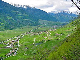
Etsch in the lower Vinschgau |
||
The Adige [ ɛtʃ ] ( Italian Adige [ aːdid͡ʒe ], Ladin Adesc , trentinisch Ades , Romansh , on Romans Athesis ) with its 415 km the second longest river in Italy . It rises in the mountains in South Tyrol , flows through the Adige Valley and the Po Valley in northern Italy and flows south of the Laguna Veneta into the Adriatic Sea , a side basin of the Mediterranean Sea .
course
The Etsch rises in South Tyrol on the Reschenpass ( 1550 m , 46 ° 50 ′ 7.2 ″ N , 10 ° 30 ′ 53.3 ″ E ), which separates its river basin from that of the Inn . This is where the 200-kilometer-long Adige Valley begins. The Etsch flows through the Reschensee ( 1482 m ) and the Haidersee ( 1450 m ) near its source and reaches the Malser Haide and the flat valley floor of Glurns with a rapid gradient . Here the Rambach flows from the Swiss Münstertal into the Etsch. It flows eastwards through the Vinschgau , overcomes the Töll valley threshold and reaches the Merano valley basin. In Merano the Passer flows into the Adige, which then passes the flat valley floor towards Bolzano .
The Eisack river, which comes from the Brenner and is superior in terms of water flow, flows to it near Bozen, and from here on it was traditionally considered navigable. The Etsch flows south of Bozen through the Unterland and leaves South Tyrol through the Salurner Klause . She passed a stream near Rovereto . The 10 km long Etsch-Gardasee tunnel begins at Mori, which creates a connection to Lake Garda and through which parts of the Etsch can be diverted into Lake Garda during floods. Shortly before Verona, it flows through the Veronese Klause ( Chiusa di Verona , German also outdated Berner Klause - see Dietrich von Bern ) and then enters the Po plain . The flat banks are now swampy, the river itself muddy and sluggish. The lower reaches of the Adige are often connected to the mouth of the Po .
One arm of the Adige branches off to the south at Legnago to the Tartaro and flows into the Valli Grandi in this, another arm branches above Castelbaldo to the south and flows as Canale Bianco to the east, is connected to the Po Grande and finally flows into the Po di Levante. A third arm, the Naviglio Adigetto, branches off to the southeast at Badia and flows to it in the Po Delta.
The Adige itself flows into the Adriatic Sea at Porto Fossone, Province of Rovigo , and borders the Po Delta to the north.
Hydrology
With a water flow of 235 m³ / s, the Etsch is the fourth largest river in Italy (after the Po, Ticino and Tiber ) and the second longest (after the Po). Both its main hydrological branch and its longest flow path are not formed by the Etsch itself, but rather by the Ahr , Rienz and Eisack rivers .
Adige regulation
From 1869 the Etsch was regulated and straightened according to plans by Martin von Kink in the section south of Meran ( Burggrafenamt ) and Bozen ( South Tyrolean Unterland ), whereby the river dams were brought to high water level for the first time after the river had been straightened in the city of Trento in 1859 . In 1902 the stretch of the river of the middle Vinschgau was straightened , in 1905 the section Naturns - Töll was also straightened.
The Etsch-Gardasee tunnel was opened in 1959 to regulate the Adige floods in southern Trentino . The approximately ten kilometer long tunnel connects the Adige north of Mori with Lake Garda , the tunnel exit is at the southern exit of Torbole . It has been used eleven times since it opened ( as of 2020 ), with around 79,270,800 m³ of water being discharged into Lake Garda in 1965, which led to an increase in Lake Garda level of over 21 cm.
Others
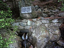
The source of the Etsch is not the one marked on the Reschenpass, but is located above the village of Reschen near a bunker of the Vallo Alpino (Alpine wall).
Quotes
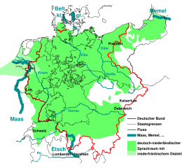
The verse “From the Meuse to the Memel , from the Etsch to the Belt ” from the first stanza of the song of the Germans describes certain historical settlement borders of the German-speaking ethnic groups. South Tyrol , located on the upper reaches of the Etsch, is still predominantly German-speaking.
In the Bolzano mountaineering song , which is considered the unofficial hymn of the South Tyroleans, the river is mentioned in the first stanza, which reads as follows: "[...] There where the Eisack jumps out of the narrow cliff, from Sigmundskron along the Etsch to the Salurner Klaus' . "
In 1932 the composer Felice Carena wrote a concert waltz “Secrets of the Etsch”, which is part of the standard repertoire for wind orchestras.
literature
- Helmut Gritsch: Shipping on the Etsch and Inn . In: Uta Lindgren (Ed.): Alpenübergangs vor 1850 , Stuttgart: Steiner 1987, pp. 47–63. ISBN 3-515-04847-2 .
- Peter Ortner , Christoph Mayr: The Etsch. Nature and culture image of an Alpine river , Bozen: Athesia 1984. ISBN 978-88-7014359-1 .
- Eugenio Turri: L'Adige: il fiume, gli uomini, la storia , Verona: Cierre 1997. ISBN 88-85923-40-2 .
- Kurt Werth: History of the Adige between Meran and San Michele. River regulation, drainage of the Möser, flood protection , Bozen: Athesia 2014. ISBN 978-88-6839-029-7 .
Web links
- Etsch on the website of the South Tyrolean Environment Agency
Individual evidence
- ↑ http://www.peter-hug.ch/lexikon/Etsch
- ↑ http://www.reschensee.it/index_htm_files/Etschursprung%20Zammlung%20I.pdf
- ↑ Law and Ordinance Gazette for the ducal county of Tyrol and the state of Vorarlberg . Born in 1905, XL. Piece, No. 75, p. 421ff.
- ↑ The Lake Garda level in Italian (PDF; 2.16 MB), accessed on August 23, 2017.


