
Štramberk
| Štramberk | |||||
|---|---|---|---|---|---|
|
|||||
| Basic data | |||||
| State : |
|
||||
| Region : | Moravskoslezský kraj | ||||
| District : | Nový Jičín | ||||
| Area : | 933 ha | ||||
| Geographic location : | 49 ° 36 ' N , 18 ° 7' E | ||||
| Height: | 415 m nm | ||||
| Residents : | 3,438 (Jan 1, 2019) | ||||
| Postal code : | 742 66 | ||||
| License plate : | T | ||||
| traffic | |||||
| Street: | Nový Jičín - Kopřivnice | ||||
| Railway connection: | Studénka – Veřovice | ||||
| structure | |||||
| Status: | city | ||||
| Districts: | 1 | ||||
| administration | |||||
| Mayor : | Andrea Hlávková (as of 2019) | ||||
| Address: | Náměstí 9 742 66 Štramberk |
||||
| Municipality number: | 599948 | ||||
| Website : | www.stramberk.cz | ||||


Štramberk ( German Stramberg ) is a city in the Czech Republic . It is located eight kilometers east of Nový Jičín and belongs to the Okres Nový Jičín .
geography
Štramberk is located in a basin in the Štramberská vrchovina ( Stramberger Bergland ). To the north rises the castle hill (509 m nm) with the Štramberk castle ruins , in the northeast the Bílá hora (557 m nm) and south of the Kotouč (511 m nm). To the west lies the Sedlnice valley. The town is located in the Podbeskydí Nature Park.
Neighboring towns are Závišice in the north, Kopřivnice in the east, Lichnov in the south-east, Ženklava in the south, Životice u Nového Jičína in the south-west, Žilina in the west and Rybí in the north-west.
history


The mountain town in the center of the Štramberk plateau in the foothills of the Beskids, first mentioned in 1211, is also called "Moravian Bethlehem". It was named a city on December 4, 1359 by the son of the Bohemian King John of Luxembourg , the Moravian Margrave Johann Heinrich of Luxembourg .
On May 8, 1241 (Ascension Day) there was a battle between the Mongols and the local Strambergers. In memory of the victims of the Mongols, who are said to have cut off the ears of the Strambergers, pastries made from gingerbread dough, the so-called "Štramberk ears (ear waddles)", have been made since then.
After the Munich Agreement , the place was added to the German Reich and until 1945 belonged to the district of Neu Titschein , administrative district of Troppau , in the Reichsgau Sudetenland .
Demographics
| year | Residents | Remarks |
|---|---|---|
| 1834 | 2,507 | in 398 houses, mostly Catholics (30 Protestants) |
| 1857 | 2,331 | |
| 1900 | 3,052 | Czech residents, in 439 houses |
| 1930 | 3,591 | , including 3,497 Czechs, 46 Germans and 45 foreigners in 577 houses |
| 1939 | 3,524 | |
| 1950 | 3,373 | in 678 houses |
| 1970 | 4.191 | in 773 houses |
| 2001 | 3,408 | in 910 houses |
Community structure
No districts are shown for the city of Štramberk. Basic settlement units are Bařiny, Kotouč, Libotínské Paseky, Rybské Paseky and Štramberk. Štramberk to also include the settlements Drážné, Na Kanadě, Na Kozine and Tamovice ( fir village )
Attractions
The historic city center was declared an urban monument reserve in 1969 .
- The town is dominated by the ruins of the Štramberk Castle (German Strahlberg) with its cylindrical tower (Trúba), which is now used as a lookout tower.
- Kotouč mountain with a view, important prehistoric finds were made in three caves between 1878 and 1883 , including the remains of the leg bone of a Neanderthal child.
- Folk architecture complex of log houses from the 18th and 19th centuries
- Šipka cave
- Bílá Hora lookout tower
- Botanical garden in a former limestone quarry
- Museum about the illustrator Zdeněk Burian
- Typical Moravian wooden houses
- Location views

Tower of the castle ruins

Medieval gate
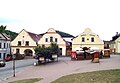
Old houses

Typical wooden house


.jpg)

sons and daughters of the town
- Martin Stephan (1777–1846), German-American clergyman
- Jiří Hanzelka (1920–2003), world traveler, author, photographer, signer of Charter 77
Web links
- Website (Czech, English, German, Polish)
- Location description on kuhlaendchen.de
Individual evidence
- ↑ http://www.uir.cz/obec/599948/Stramberk
- ↑ Český statistický úřad - The population of the Czech municipalities as of January 1, 2019 (PDF; 7.4 MiB)
- ↑ Joseph von Hormayr zu Hortenburg : The golden chronicle of Hohenschwangau, the castle of the Welfs, the Hohenstauffen and the Scheyren. Franz, Munich 1842, part II, p. 63, top right column.
- ↑ On the review of Raumer's Hohenstauffen : In: Jahrbücher der Literatur , Volume 43, Vienna 1828, p. 256 ff., Especially p. 257.
- ^ Gregor Wolny : The Margraviate of Moravia, presented topographically, statistically and historically . Volume I: Prerauer Kreis , Brno 1835, p. 341.
- ^ Carl Kořistka : The Margraviate of Moravia and the Duchy of Silesia in their geographical relationships . Vienna and Olmüz 1861, pp. 268–269 .
- ↑ a b Meyer's Large Conversation Lexicon . 6th edition, Volume 19, Leipzig and Vienna 1909, p. 92.
- ↑ a b c d e Historický lexikon obcí České republiky 1869–2005 , Part 1, pp. 724–725
- ↑ a b Michael Rademacher: German administrative history from the unification of the empire in 1871 to the reunification in 1990. Neu Titschein district. (Online material for the dissertation, Osnabrück 2006).
- ↑ https://www.kuhlaendchen.de/media/bilder/hk-neutitschein/307_Neutitschein-Stramberg.pdf
- ↑ http://www.uir.cz/zsj-obec/599948/Obec-Stramberk