
A1 road
| A1 road in the UK | |

|
|
| |
|
| map | |
 |
|
| Basic data | |
| Operator: | Highways Agency (except Greater London) |
| further operator: | Transport Scotland |
| Start of the street: |
City of London ( 51 ° 31 ′ N , 0 ° 6 ′ W ) |
| End of street: |
Edinburgh ( 55 ° 57 ′ N , 3 ° 11 ′ W ) |
| Overall length: | 660 km (410.1 mi ) |
 |
|
| The A1 at Water Newton, west of Peterborough | |
The A1 road ( English for ' A1 road '), expanded in sections to form the A1 (M) motorway, is a trunk road in Great Britain and connects London with Edinburgh . It is the longest main thoroughfare in Great Britain at 660 km (410 miles).
As the primary route (green signs), the A1 is part of the UK's most important trunk road network beneath the motorways.
Route
The A1 largely follows the course of the historic Great North Road . It begins in London on New Change Street at St Paul's Cathedral and leaves the City of London first in a north-westerly direction until it turns north at Edgware and crosses the London ring road at Bignell's Corner .
Now it runs northwards in different stages of development roughly parallel to the East Coast Main Line through medium-sized cities. From Alconbury, where the A14 from Cambridge joins, it is continuously developed as a bypass road, sometimes also as a motorway. It passes Peterborough and Stamford , crosses Rutland , the smallest English county, passes Grantham and Newark-on-Trent , passes the remains of Sherwood Forest near Retford and reaches Yorkshire.
Through West, South and North Yorkshire it goes past Doncaster and Leeds almost straight north and a little west to Scotch Corner . Here the road turns a little east again and runs past Darlington through County Durham to Newcastle upon Tyne , which it circles to the west as a bypass.
Then it goes straight north again until both the Scottish border and the North Sea coast are reached at Berwick upon Tweed , the northernmost town in England. Now the road leads northwest to Dunbar and then straight west to Edinburgh, whose eastern districts are crossed. The street ends at Waterloo Place just north of Waverley Station, the main railway station in the Scottish capital.
State of development
Since the introduction of the numbering , the A1 has been expanded in sections and re-routed as a bypass road, so that through-roads are largely avoided today. On the approximately 450 kilometers between Alconbury and the Scottish border, i.e. roughly the middle two thirds of the total route, the A1 no longer has any inner-local sections.
With the exception of a few sections in London, Edinburgh and between Dunbar (east of Edinburgh) and Morpeth (north of Newcastle ), the A1 has at least two, often even more, lanes in each direction (up to four each, between Alconbury and Norman Cross).
Despite the multi-lane expansion, the road is by no means free of intersections in the sections without motorway status. Side streets or farmsteads are often connected via simple junctions, exits via the opposite lane (from the overtaking lane) are common, some larger intersections are designed as roundabouts, and explicit signage is required to restrict certain sections to motor vehicles.
Instead of the usual indication of travel destinations on the traffic signs, the signs for the access roads to the A1 between London and Newcastle usually only contain the general directions "The NORTH" and "The SOUTH" ("The South") . These are only indicated in the immediate vicinity of important destinations.
A1 (M)
Large sections of the A1 have now been upgraded to motorway status and are officially dedicated as a motorway. In these sections, the street designation bears the addition (M) for motorway , the signs are also carried out there on a blue background, as is customary on the motorway, and the traffic regulations applicable to motorways apply. Vehicles without a motorway authorization must therefore avoid or drive around these sections.
The A1 (M) does not involve the M1 motorway are confused. The M1 touches the A1 at both ends near London and Leeds , but otherwise has nothing to do with it.
Sections A1 (M)
| southern end | north end | Length in km / in miles |
|---|---|---|
| South Mimms | Baldock | 39 / 24.2 |
| Alconbury | Peterborough | 20.6 / 12.8 |
| Blyth | Carcroft | 24.8 / 15.4 |
| Ferrybridge | Gateshead | 150.7 / 93.6 |
The long Ferrybridge – Gateshead section was created by closing a 19 km (12 mile) gap between Leeming and Barton, the last section of which opened on March 29, 2018.
The section from Edinburgh to Dunbar is subject to motorway-like restrictions, but is not a motorway in terms of traffic law and also bears the normal designation A1.
photos
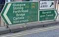
North end of the A1 in Edinburgh

A two-lane stretch of the A1 in Scotland between Berwick and Dunbar

A1 south of Doncaster with separate lanes and two lanes in each direction, but no motorway expansion
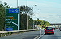
Signs when changing to motorway status A1 (M). Non-motorway traffic must exit here.

The A1 (M) section Alconbury – Peterborough, here in a north direction, four lanes in each direction

Exit right out of the passing lane via the oncoming lane in Lincolnshire
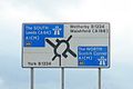
Signs for the Wetherby ramp onto the A1 (M). In addition to the cardinal points, Leeds and Scotch Corner are also given as the next destinations.


_south_of_Peterborough.jpg)


See also
Web links
Individual evidence
- ↑ Official project page of Highways England ( Memento of the original from April 6, 2018 in the Internet Archive ) Info: The archive link was inserted automatically and has not yet been checked. Please check the original and archive link according to the instructions and then remove this notice. , accessed April 11, 2018.

Great Britain:
M1 |
M2 |
M3 |
M4 |
M5 |
M6 |
M6 great |
M8 |
M9 |
M10 |
M11 |
M18 |
M20 |
M23 |
M25 |
M26 |
M27 |
M32 |
M40 |
M42 |
M45 |
M48 |
M49 |
M50 |
M53 |
M54 |
M55 |
M56 |
M57 |
M58 |
M60 |
M61 |
M62 |
M65 |
M66 |
M67 |
M69 |
M73 |
M74 |
M77 |
M80 |
M90 |
M180 |
M181 |
M271 |
M275 |
M602 |
M606 |
M621 |
M876 |
M898
Northern Ireland: M1 | M2 | M3 | M5 | M12 | M22
Motorways with A designations: A1 (M) | A3 (M) | A8 (M) | A28 (M) | A38 (M) | A48 (M) | A57 (M) | A58 (M) | A64 (M) | A66 (M) | A74 (M) | A167 (M) | A194 (M) | A308 (M) | A329 (M) | A404 (M) | A601 (M) | A627 (M) | A823 (M)
( See also: Road System in Great Britain | Road System in Ireland )