Ancón District
| Ancón District | |||
|---|---|---|---|
 Location of the district in the province of Lima |
|||
| Symbols | |||
|
|||
| Basic data | |||
| Country | Peru | ||
| region | region free | ||
| province | Lima | ||
| Seat | Ancón | ||
| surface | 299.2 km² | ||
| Residents | 62,928 (2017) | ||
| density | 210 inhabitants per km² | ||
| founding | October 29, 1874 | ||
| ISO 3166-2 | PE | ||
| Website | muniancon.gob.pe/portal/ (Spanish) | ||
| politics | |||
| Alcalde District | Pedro John Barrera Bernui (2019-2022) | ||
| Political party | Partido Democrático Somos Perú | ||
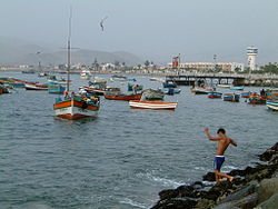
| Port of Ancón | |||
Coordinates: 11 ° 44 ′ S , 77 ° 9 ′ W
The district of Ancón is one of the 43 urban districts of the Lima Metropolitana region in Peru . It has an area of 1206.28 km². The 2017 census counted 62,928 inhabitants. In 1993 the population was 19,695, in 2007 33,367. The city and district of Ancón are virtually identical.
Geographical location
The district of Ancón is located in the far north of the province of Lima . It has an approximately 16.5 km long coastline. The population lives in or near the bay, while in the hinterland there is barren vegetation and desert. The district extends up to 20 km inland. There the foothills of the Peruvian Western Cordillera rise with heights of up to 1987 m . The Panamericana highway runs east past the settlement area in a northerly direction.
Web links
- Municipalidad Distrital de Ancón
- Peru: Region Lima (provinces and districts) at www.citypopulation.de


