
Burgstall Haideck
| Burgstall Haideck | |
|---|---|
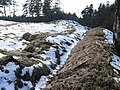
 Plateau from the south |
|
| Castle type : | Höhenburg, spur location |
| Conservation status: | Burgstall |
| Place: | Oberkotzau- Haideck |
| Geographical location | 50 ° 15 '2 " N , 11 ° 58' 13.4" E |
| Height: | 568 m above sea level NN |
The Postal Haideck is an Outbound Spur castle east of the hamlet Haideck , now amalgamated with Oberkotzau in district court .
The castle was built as the outbuilding of the ancestral seat of the von Kotzau family . It was destroyed in a feud against the imperial cities , especially Eger , in 1335 or 1337 and was then considered a desolate castle . The Hussites destroyed an apparently rebuilt tower. In 1540 stones were removed for buildings in Oberkotzau. In 1607 a little castle burned down below the castle stables and was rebuilt a little later. Owners were u. a. the Zedtwitz , the Müffling and several times the Hohenzollern as burgraves, margraves and barons of Kotzau.
The Burgstall lies at 568 m above sea level. NN high rock plateau of the Haidberg. The plateau has a steep gradient and is protected by rocks in the west and east. The entrance is also to the west. The plateau surface, which has not yet been explored in more detail, shows clear unevenness in the ground, traces of a wall can be seen.
Traces of a wall in the north
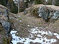
Gradient in the east


literature
- August Gebeßler : City and District of Hof . The Art Monuments of Bavaria , Brief Inventories , Volume VII . Deutscher Kunstverlag , Munich 1960, p. 43.
- Dietmar Herrmann, Helmut Süssmann: Fichtel Mountains, Bavarian Vogtland, Steinwald, Bayreuther Land. Lexicon . Ackermannverlag, Hof (Saale) 2000, ISBN 3-929364-18-2 , p. 247 f .
- Wilhelm Malter : Upper Franconia East . Heroldsberg 1984. pp. 351f.
- Klaus Schwarz: The prehistoric and early historical monuments in Upper Franconia . (Material booklets on Bavarian prehistory, series B, volume 5). Verlag Michael Lassleben, Kallmünz 1955, p. 107.
Web links
- Aerial photo with the BayernViewer


Castles: Brandstein Castle | Castle Bug | Döhlau Castle | Feilitzsch Castle | Freilitzsches Castle | Gattendorf Castle | Gottsmannsgrün Castle | Gumpertsreuth Castle | Hallerstein Castle (ruin) | Hohenberg Castle | Issigau Castle | Köditz Castle | Konradsreuth Castle | Lippertsgrün Castle | Neuhaus Castle | Niedernberg Castle | Oberkotzau Castle | Oberschwarzenstein Castle | Regnitzlosau Castle | Reitzenstein Castle | Rudolphstein Castle | Schauenstein Castle | Schnarchenreuth Castle | Schottenhammer Castle | Schwarzenbach Castle | Old Castle (Selbitz) | New Castle (Selbitz) | Parkschlößchen Bad Steben | Stockenroth Castle (exited) | Thierbach Castle (ruin) | Unterschwarzenstein Castle | Weißdorf moated castle | Zedtwitz Castle
Castles and ruins: Bernstein Castle (dismissed) | Braunstein castle ruins | Bug Castle (exited) | Feilitzsch Castle (exited) | Förbau Castle (exited) | Gattendorf castle ruins | Haideck Castle (exited) | Hirschstein castle ruins | Hohenrod Castle (exited) | Lichtenberg castle ruins | Ostburg castle ruins | Radeck Castle (exited) | Rehau Castle (exited) | Reitzenstein Castle (exited) | Rodesgrün Castle (exited) | Saalenstein Castle (exited) | Schlegel Castle | Sparneck Castle (exited) | Thierbach Castle (exited) | Trogen Castle (exited) | Uprode castle ruins | Waldsteinburg castle ruins | Wallenrode Castle (exited) | Weidenstein Castle (exited) | Zedtwitz Castle (exited)
Tower hill castles (all gone): Tower hill Altes Schloss (Helmbrechts) | Tower Hill Old Castle (Stobersreuth) | Tower hill Autengrün | Dobenck Castle | Hartungs Castle | Hinterer Buberg tower hill | Hofstatt Tower Hill | Köditz Tower Hill | Marlesreuth Tower Hill | Mechlenreuth Tower Hill | Münchberg Tower Hill | Tower Hill Münchenreuth | Tower Hill Musten | Naila Tower Hill | Tower Hill Nentschau | Regnitzlosau tower hill | Regnitzlosau II tower hill | Reuthlas Tower Hill | Rodesgrün Tower Hill | Schweinsbach Tower Hill | Tower Hill Castle Seuckenreuth | Tauperlitz Tower Hill Castle | Töpen Castle | Tower Hill Wahlhöhe | Waldschlösschen tower hill | Tower hill castle Woja
Manor houses: Rittergut Bug | Dorschenhammer Castle | Knight seat Feilitzsch (Schlössle) | Manor Frog Green | Knight seat Isaar | Joditz Manor | Löwelsches Gut | Manor Moss | Rittergut Nestelreuth | Upper Gut (Schwarzenbach am Wald) | Lower Gut (Schwarzenbach am Wald) | Trogen Manor | Manor Trogen II | Unterblade Spur Manor
Castle stables (lost, unknown castles): Burgstall Altes Schloss (Brunnenthal) | Burgstall Am Rothen Berg | Burgstall Am Weidenstein | Burgstall Blankeneck | Burgstall Brunnenthal | Förbau ring wall system | Burgstall Osseck | Burgstall Raitschin | Burgstall Schartenmauer
Fortified churches: fortified church Bad Steben (St. Walburga) | Fortified church Berg (St. Jakobus) | Fortified church Geroldsgrün (St. Jakobus) | Fortified church Köditz (St. Leonhard)
Guard towers: Weissenstein guard tower