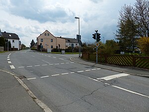
Regnitzlosau tower hill
| Regnitzlosau tower hill | ||
|---|---|---|
|
Formerly a tower hill, today a junction |
||
| Creation time : | mentioned around 1390 | |
| Castle type : | Niederungsburg, moth | |
| Conservation status: | Burgstall, modern overbuilt site | |
| Place: | Regnitzlosau | |
| Geographical location | 50 ° 17 '54.9 " N , 12 ° 2' 46.5" E | |
| Height: | 527 m above sea level NN | |
|
|
||
The tower hill Regnitzlosau is a defunct tower castle (Motte) in Regnitzlosau in the Upper Franconian district of Hof .
history
Around 1390 a family member of the local aristocratic Moschler with seat in Regnitzlosau was mentioned in a document ("Moschler ... j sycz zu lasaw"). The residence was on the southern edge of the village about 100 meters southwest of St. Aegidien Church . On the Bavarian premiere , a long oval core hill with a moat can be seen at the fork in the arterial roads to Rehau and Klötzlamühle . Today the state road St 2192 from Hof to Rehau meets the district road HO 4 , which leads from the Klötzlamühle into the village and on to Schwesendorf . Only the western edge of the intersection, which is covered with trees, is not built over, and no traces of the terrain are visible above ground.
In the immediate vicinity was Regnitzlosau Castle from the 15th century. Another tower hill was in the valley on the southern Regnitz , today in the area of the Postplatz 5 building.
description
The castle site was on the front part of a broad, north-north-west facing mountain spur that protrudes into the triangle of the mouth of the Kleppermühlbach and the southern Regnitz . The facility was located around 20 meters above the valley floor. Today the castle site is almost completely destroyed by road construction. However, the castle complex can still be described on the basis of the map from 1853: The oval tower hill had a diameter of around 30 × 20 meters. The hill was not significantly elevated in relation to the rising foreland in the south-southeast, a ring trench served as approach protection . This trench was cut into the flat terrain in the east and south and was filled in around 1940. On the sides of the valley slopes to the west and north-west, an outer wall was laid before him.
literature
- Michael Brix , Karl-Ludwig Lippert : Former district of Rehau and town of Selb . The art monuments of Bavaria , brief inventories, XXXIV. Band . Deutscher Kunstverlag , Munich 1974, p. 68.
- Klaus Schwarz: The prehistoric and early historical monuments in Upper Franconia . (Material booklets on Bavarian prehistory, series B, volume 5). Verlag Michael Lassleben, Kallmünz 1955, p. 150.
Web links
- Entry on Regnitzlosau in the private database "Alle Burgen".
- Bavarian premiere in the BayernAtlas ( online )


