
Ceres (Piedmont)
| Ceres | ||
|---|---|---|

|
|
|
| Country | Italy | |
| region | Piedmont | |
| Metropolitan city | Turin (TO) | |
| Coordinates | 45 ° 19 ′ N , 7 ° 23 ′ E | |
| height | 704 m slm | |
| surface | 27 km² | |
| Residents | 1,033 (Dec. 31, 2019) | |
| Population density | 38 inhabitants / km² | |
| Post Code | 10070 | |
| prefix | 0123 | |
| ISTAT number | 001072 | |
| Popular name | Ceresini | |
| Patron saint | Assumption Day | |
| Website | www.comune.ceres.to.it | |
 View from Monte Crestà to Ceres |
||

Ceres ( Piedmontese Céres , Franco-Provencal Sèress , French Cérès ) is a municipality with 1033 inhabitants (as of December 31, 2019) in the Italian metropolitan city of Turin (TO), Piedmont region . The municipality is the main town of the mountain community association Comunità montana Valli di Lanzo, Ceronda e Casternone .
The neighboring municipalities are Groscavallo , Chialamberto , Cantoira , Monastero di Lanzo , Ala di Stura , Mezzenile and Pessinetto . The place is under the patronage of the Assumption .
geography
The municipality covers an area of 27 km².
The terminus of the Turin – Ceres railway line is in Ceres. On the provincial road it is about 43 km to the southeast of Turin.
- Photo gallery

Church of the Assumption

Ceres Town Hall
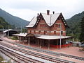
Railway station in Ceres


Web links
- Information at comuni-italiani.it (Italian)
Individual evidence
- ↑ Statistiche demografiche ISTAT. Monthly population statistics of the Istituto Nazionale di Statistica , as of December 31 of 2019.

Agliè | Airasca | Ala di Stura | Albiano d'Ivrea | Almese | Alpette | Alpignano | Andezeno | Andrate | Angrogna | Arignano | Avigliana | Azeglio | Bairo | Balangero | Baldissero Canavese | Baldissero Torinese | Balme | Banchette | Barbania | Bardonecchia | Barone Canavese | Beinasco | Bibiana | Bobbio Pellice | Bollengo | Borgaro Torinese | Borgiallo | Borgofranco d'Ivrea | Borgomasino | Borgone Susa | Bosconero | Brandizzo | Bricherasio | Brosso | Brozolo | Bruino | Brusasco | Bruzolo | Buriasco | Burolo | Busano | Bussoleno | Buttigliera Alta | Cafasse | Caluso | Cambiano | Campiglione-Fenile | Candia Canavese | Candiolo | Canischio | Cantalupa | Cantoira | Caprie | Caravino | Carema | Carignano | Carmagnola | Casalborgone | Cascinette d'Ivrea | Caselette | Caselle Torinese | Castagneto Po | Castagnole Piemonte | Castellamonte | Castelnuovo Nigra | Castiglione Torinese | Cavagnolo | Cavour | Cercenasco | Ceres | Ceresole Reale | Cesana Torinese | Chialamberto | Chianocco | Chiaverano | Chieri | Chiesanuova | Chiomonte | Chiusa di San Michele | Chivasso | Ciconio | Cintano | Cinzano | Cirié | Pianos | Coassolo Torinese | Coazze | Collegno | Colleretto Castelnuovo | Colleretto Giacosa | Condove | Corio | Cossano Canavese | Cuceglio | Cumiana | Cuorgnè | Druento | Exilles | Favria | Feletto | Fenestrelle | Fiano | Fiorano Canavese | Foglizzo | Forno Canavese | Frassinetto | Front | Frossasco | Garzigliana | Gassino Torinese | Germagnano | Giaglione | Giaveno | Givoletto | Gravere | Groscavallo | Grosso | Grugliasco | Ingria | Inverso Pinasca | Isolabella | Issiglio | Ivrea | La Cassa | La Loggia | Lanzo Torinese | Lauriano | Leinì | Lemie | Lessolo | Levone | Locana | Lombardore | Lombriasco | Loranzè | Luserna San Giovanni | Lusernetta | Lusigliè | Macello | Maglione | Mappano | Marentino | Massello | Mathi | Mattie | Mazzè | Meana di Susa | Mercenasco | Mezzenile | Mombello di Torino | Mompantero | Monastero di Lanzo | Moncalieri | Moncenisio | Montaldo Torinese | Montalenghe | Montalto Dora | Montanaro | Monteu da Po | Moriondo Torinese
Nichelino | Noasca | Nole | Nomaglio | None | Novalesa | Oglianico | Orbassano | Orio Canavese | Osasco | Osasio | Oulx | Ozegna | Palazzo Canavese | Pancalieri | Parella | Pavarolo | Pavone Canavese | Pecetto Torinese | Perosa Argentina | Perosa Canavese | Perrero | Pertusio | Pessinetto | Pianezza | Pinasca | Pinerolo | Pino Torinese | Piobesi Torinese | Piossasco | Piscina | Piverone | Poirino | Pomaretto | Pont-Canavese | Porte | Pragelato | Prali | Pralormo | Pramollo | Prarostino | Prascorsano | Pratiglione | Quagliuzzo | Quassolo | Quincinetto | Reano | Ribordone | Riva presso Chieri | Rivalba | Rivalta di Torino | Rivara | Rivarolo Canavese | Rivarossa | Rivoli | Robassomero | Rocca Canavese | Roletto | Romano Canavese | Ronco Canavese | Rondissone | Rorà | Rosta | Roure | Rubiana | Rueglio | Salassa | Salbertrand | Salerano Canavese | Salza di Pinerolo | Samone | San Benigno Canavese | San Carlo Canavese | San Colombano Belmonte | San Didero | San Francesco al Campo | San Germano Chisone | San Gillio | San Giorgio Canavese | San Giorio di Susa | San Giusto Canavese | San Martino Canavese | San Maurizio Canavese | San Mauro Torinese | San Pietro Val Lemina | San Ponso | San Raffaele Cimena | San Sebastiano da Po | San Secondo di Pinerolo | Sangano | Sant'Ambrogio di Torino | Sant'Antonino di Susa | Santena | Sauze d'Oulx | Sauze di Cesana | Scalenghe | Scarmagno | Sciolze | Sestriere | Settimo Rottaro | Settimo Torinese | Settimo Vittone | Sparone | Strambinello | Strambino | Susa | Tavagnasco | Torrazza Piemonte | Torre Canavese | Torre Pellice | Trana | Traversella | Traves | Trofarello | Turin | Usseaux | Usseglio | Vaie | Valchiusa | Val della Torre | Val di Chy | Valgioie | Vallo Torinese | Valperga | Valprato Soana | Varisella | Vauda Canavese | Venaria Reale | Venaus | Verolengo | Verrua Savoia | Vestignè | Vialfrè | Vidracco | Vigone | Villafranca Piemonte | Villanova Canavese | Villar Dora | Villar Focchiardo | Villar Pellice | Villar Perosa | Villarbasse | Villareggia | Villastellone | Vinovo | Virle Piemonte | Vische | Vistrorio | Viù | Volpiano | Volvera