
Champétières
| Champétières | ||
|---|---|---|
.svg)
|
|
|
| region | Auvergne-Rhône-Alpes | |
| Department | Puy-de-Dôme | |
| Arrondissement | Ambert | |
| Canton | Ambert | |
| Community association | Ambert Livradois Forez | |
| Coordinates | 45 ° 31 ' N , 3 ° 42' E | |
| height | 534-1,205 m | |
| surface | 18.54 km 2 | |
| Residents | 272 (January 1, 2017) | |
| Population density | 15 inhabitants / km 2 | |
| Post Code | 63600 | |
| INSEE code | 63081 | |

Champétières is a French municipality with 272 inhabitants (as of January 1 2017) in the department of Puy-de-Dôme in the region Auvergne Rhône-Alpes . It belongs to the Arrondissement of Ambert and the canton of Ambert .
geography
Champétières is located about 50 kilometers southeast of Clermont-Ferrand and 52 kilometers west-northwest of Saint-Étienne in the Livradois-Forez Regional Nature Park . Champétières is surrounded by the neighboring communities of Saint-Ferréol-des-Côtes in the north and east, Marsac-en-Livradois in the south and south-east, Chambon-sur-Dolore in the west and south-west and Le Monestier in the north-west.
Population development
| year | 1962 | 1968 | 1975 | 1982 | 1990 | 1999 | 2006 | 2013 |
| Residents | 351 | 307 | 247 | 233 | 247 | 258 | 252 | 244 |
| Source: Cassini and INSEE | ||||||||
Attractions
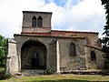
- Saint-Sébastien church from the 15th century, a historic monument since 1990
- Notre-Dame-de-Mons church from the 15th century, a historic monument since 1990
- Le Bouy castle from the 16th century, monument historique since 2010

Saint-Sébastien church
Notre-Dame-de-Mons church

Le Bouy Castle


Web links
Commons : Champétières - collection of images, videos and audio files