
Marsac-en-Livradois
| Marsac-en-Livradois | ||
|---|---|---|
.svg)
|
|
|
| region | Auvergne-Rhône-Alpes | |
| Department | Puy-de-Dôme | |
| Arrondissement | Ambert | |
| Canton | Ambert | |
| Community association | Ambert Livradois Forez | |
| Coordinates | 45 ° 29 ′ N , 3 ° 44 ′ E | |
| height | 531–1,041 m | |
| surface | 48.46 km 2 | |
| Residents | 1,458 (January 1, 2017) | |
| Population density | 30 inhabitants / km 2 | |
| Post Code | 63940 | |
| INSEE code | 63211 | |

Marsac-en-Livradois is a French commune with 1,458 inhabitants (as of January 1 2017) in the department of Puy-de-Dôme in the region Auvergne Rhône-Alpes . It belongs to the Arrondissement of Ambert and the canton of Ambert .
geography
Marsac-en-Livradois is located about 63 kilometers southeast of Clermont-Ferrand and about 50 kilometers west of Saint-Étienne in the Livradois-Forez Regional Nature Park . The river Dore flows through Marsac-en-Livradois . Marsac-en-Livradois is surrounded by the neighboring communities of Champétières in the north and north-west, Saint-Ferréol-des-Côtes in the north, Ambert in the north and north-east, Saint-Martin-des-Olmes in the north-east, Saint-Just in the east, Chaumont- le-Bourg in the east and south-east, Arlanc in the south, Saint-Bonnet-le-Chastel in the west and Chambon-sur-Dolore in the west and north-west.
The former route nationale 106 (today's D906) runs through the municipality .
Population development
| year | 1962 | 1968 | 1975 | 1982 | 1990 | 1999 | 2006 | 2013 |
| Residents | 1,633 | 1,523 | 1,421 | 1,291 | 1,352 | 1,329 | 1,427 | 1,462 |
| Source: Cassini and INSEE | ||||||||
Attractions
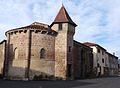
- Notre-Dame church, built in the 12th century, rebuilt in the 16th century, monument historique since 1961

Notre-Dame church
Chapel of Les Pénitents blancs

