
Cuiabá
| Município de Cuiabá Cuiabá |
|||
|---|---|---|---|
 |
|||
|
|||
| Coordinates | 15 ° 36 ′ S , 56 ° 6 ′ W | ||
 Location of the municipality in the state of Mato Grosso Location of the municipality in the state of Mato Grosso
|
|||
| Symbols | |||
|
|||
| founding | April 8, 1719 (age 301) September 17, 1818 Cidade (age 201) |
||
| Basic data | |||
| Country | Brazil | ||
| State | Mato Grosso | ||
| ISO 3166-2 | BR-MT | ||
| Região intermediária | Cuiabá (since 2017) | ||
| Região imediata | Cuiabá (since 2017) | ||
| Metropolitan area | Vale do Rio Cuiabá | ||
| height | 177 m | ||
| Waters | Rio Cuiabá | ||
| climate | tropical, Aw | ||
| surface | 3,266.5 km² | ||
| Residents | 551,098 (2010) | ||
| density | 168.7 Ew. / km² | ||
| estimate | 612,547 (July 1, 2019) | ||
| Parish code | IBGE : 5103403 | ||
| Post Code | 78000-000 | ||
| Time zone | UTC −4 | ||
| Website | www.cuiaba.mt.gov.br (Brazilian Portuguese) | ||
| politics | |||
| City Prefect | Emanuel Pinheiro (2017-2020) | ||
| Political party | MDB | ||
| Culture | |||
| Patron saint | Senhor Bom Jesus | ||
| City festival | April 8th (foundation festival) | ||
| economy | |||
| GDP | 22,203,168 thousand R $ 37,930 R $ per person (2016) |
||
| HDI | 0.785 (2010) | ||


Cuiabá , pronounced kujaˈba , officially Portuguese Município de Cuiabá , is the capital of the Brazilian state of Mato Grosso . It had an estimated population as of July 1, 2019 of 612,547 people. It is the center of the metropolitan area Vale do Rio Cuiabá , in which over 1,032,000 people live.
history
In the 18th century, the region around Cuiabá was explored by Bandeirantes who came up the Rio Tietê in search of gold and slaves . The city itself was founded in 1719, the name going back to the Indian word "Ikuiapá", which means "place of the harpoon". The location of today's Rosary Church in the center of the city was the site of a rich gold vein at the time. The gold discoveries brought a large number of migrants to the city. In 1746 the city was largely destroyed by an earthquake.
After the exploitation of the gold deposits was no longer profitable, agriculture was the only industry in Cuiabá and the surrounding area. The city's development stagnated for several decades.
In 1818 Cuiabá was declared a city and in 1835 the capital of the province of Mato Grosso . In the 1850s it gained strategic importance during the Triple Alliance War , but then development stagnated again until the 1930s, when the development of the hinterland of Brazil was specifically promoted as part of the “March to the West”. Since the 1960s in particular, the city has been able to establish itself as the “gateway to the Amazon ”, a process that continues to this day.
Current projects that will increase the importance of Cuiabá are the Paraguay Canal , the railway connection to Porto dos Santos and the construction of the national road to the north; it should go as far as Santarém when it is completed .
geography
Cuiabá prides itself on being in the geographic center of South America. At the same time, it is one of the gates into the Pantanal . Greater Cuiabá also includes the municipality of Várzea Grande , which has practically grown together with the city. The Rio Cuiabá divides the city into two parts. The territory is flat to hilly, at an altitude of 150 to 250 meters above sea level.
climate
Cuiabá has a hot and during the rainy season (from October / November to March / April) a humid climate. In the hottest months (August to October) the monthly highs rise to just under 35 ° C, in the comparatively cooler months of June and July the monthly low values drop to just under 20 ° C.
|
Average monthly temperatures and rainfall for Cuiabá
Source: WMO
|
||||||||||||||||||||||||||||||||||||||||||||||||||||||||||||||||||||||||||||||||||||||||||||||||||||||||||||||||||||||||||||||||||||||||||||||||||||||||||||||||||||||||||||||||||||
Infrastructure
traffic
Federal roads connect the city with Campo Grande in the south and via the BR-070 with Goiânia in the east and Cáceres in the west. Another federal road leads north to connect smaller communities in the north of the state to the road network and to create a connection to the state of Pará . Cuiabá is on the Transoceánica .
Cuiabá has an airport in Várzea Grande , the Aeroporto Internacional Marechal Rondon, which is almost exclusively served by domestic flights, but is also a hub for local traffic in the Midwest of Brazil.
The shipping traffic on the rivers of the region, especially the Río Paraná and the Río Paraguay, is of economic importance .
From April 30, 1891, Cuiabá owned a tram pulled by mules . It was operated for a year by the Companhia Progresso Cuiabano of the entrepreneur Manoel da Silva Monteiro, then by the Empreza Cuiabana Ferro Carril e Matadouro . The length of the route in 1911 was 6.5 km, forty mules pulled eight passenger and four freight vehicles. The poor service even caused a scandal in 1896 when the police chief placed posts in front of the depot to prevent vehicles from driving. He and the state governor were forced to resign after this incident. Plans to electrify the system were not implemented, and the tram was shut down in 1935. Since then there has never been rail traffic in Cuiabá again. On the occasion of the soccer world championship in 2014 the construction of a tram started. After irregularities, however, the construction was stopped by the court in 2015, further construction is open.
education
Cuiabá is the seat of several higher education institutions. The best known is the federal Universidade Federal de Mato Grosso (UFMT) founded in 1970 .
economy
Cuiabá lives mainly from its importance as a trading center for the huge cattle breeding areas of the state of Mato Grosso. There is also an industrial area in which light industry companies in particular work.
religion
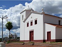
Igreja de Nossa Senhora do Rosario

Igreja Nossa Senhora do Bom Despacho

Cuiabá Cathedral

Museu Rondon
.jpg)
.jpg)


Attractions
The city itself has some churches that date from the founding time and have cultural monument status, such as the Igreja de Nossa Senhora do Rosário (translated Rosicrucian Church ) , which was built in 1722 as a chapel, then as a baroque-style church with a golden altar . The Igreja Nossa Senhora do Bom Despacho was built in the style of Notre Dame in Paris. Next to this church there is also a museum of sacred art. The Cathedral of Cuiabá was completed in 1973.
The Pedras Ramis Bucair Museum exhibits around 4,000 pieces, including the remains of a 120 million year old tyrannosaurus and stone axes from the Neolithic Age .
The Rondon Museum ( Museu Rondon in Portuguese ) is an ethnological and archaeological facility on the grounds of the Federal University and named after the Brazilian national hero and explorer Candido Rondon .
In the vicinity of Cuiabá, the Chapada dos Guimarães National Park is worth seeing, a small sandstone mountain range in which rivers and streams have cut valleys.
Águas Quentes has hot thermal springs to offer.
Cuiabá is also a good starting point for excursions into the Pantanal .
Folk festivals
During the Carnival in Cuiabá the custom of the “Boi-à-Serra” is maintained. The actors put on special misshapen costumes, which mostly represent oxen (but also other animals); these costumes are not dissimilar to those of the Bumba-meu-boi of the northeast. The disguised actors then playfully attack the audience during the carnival parade. The whole thing is accompanied by the music of the cururu .
Town twinning
sons and daughters of the town
- Francisco de Aquino Correia (1885–1956), Archbishop of Cuiabá
- José de Mesquita (1892–1961), poet
- João Carlos Muniz (1893–1960), diplomat
- Hugo Alcântara (* 1979), football player
- Éder Bonfim (* 1981), football player
- Geilson de Carvalho Soares (* 1984), football player
- Bruna Beatriz Benites Soares (* 1985), football player
- Victor da Silva (* 1995), football player
literature
- Perfil socioeconômico de Cuiabá. Volume IV. Central de Texto, Cuiabá 2010, ISBN 978-85-88696-76-1 ( digitized, PDF ).
Web links
- City Prefecture website , Prefeitura Municipal (Brazilian Portuguese)
- City Council website , Câmara Municipal (Brazilian Portuguese)
Individual evidence
- ↑ a b c Cuiabá - Panorama. In: cidades.ibge.gov.br. IBGE , accessed August 29, 2019 (Brazilian Portuguese).
- ↑ Allen Morrison: The Tramways of Brazil: A 130-Year Survey, New York 1989, ISBN 0-9622348-1-8 , p. 65 ( online ).
- ^ Igreja de Nossa Senhora do Rosário (Cuiabá, MT). In: portal.iphan.gov.br. portal.iphan.gov.br, accessed July 3, 2019 .
- ^ Joseph Barboza de Sá: Relação das povoaçoens do Cuyabá e Mato Groso de seus princípios thé os prezentes tempos. Edições UFMT, Cuiabá 1975, p. 15.
