
Déols
| Déols | ||
|---|---|---|

|
|
|
| region | Center-Val de Loire | |
| Department | Indre | |
| Arrondissement | Chateauroux | |
| Canton | Châteauroux-1 | |
| Community association | Châteauroux Métropole | |
| Coordinates | 46 ° 50 ′ N , 1 ° 42 ′ E | |
| height | 140-165 m | |
| surface | 31.74 km 2 | |
| Residents | 7,513 (January 1, 2017) | |
| Population density | 237 inhabitants / km 2 | |
| Post Code | 36130 | |
| INSEE code | 36063 | |
| Website | www.ville-deols.fr | |

Déols is a French municipality with 7513 inhabitants (at January 1, 2017) in the department of Indre in the Region Center-Val de Loire ; it belongs to the arrondissement of Châteauroux and the canton of Châteauroux-1 .
geography
The municipality of Déols is located immediately north of Châteauroux , the capital of the Indre department. The river Indre forms the border with Châteauroux . Part of the Châteauroux-Déols Marcel Dassault airport , including the terminal buildings, is located in the municipality of Déols .
Neighboring municipalities of Déols are Coings and Montierchaume in the north, Diors in the northeast, Étrechet in the east, Le Poinçonnet in the southeast, Châteauroux in the south, Saint-Maur in the southwest, Villers-les-Ormes in the west and Vineuil in the northwest.
Population development
| year | 1962 | 1968 | 1975 | 1982 | 1990 | 1999 | 2007 | 2012 |
| Residents | 6340 | 4834 | 8431 | 7639 | 7875 | 8089 | 8734 | 8062 |
Attractions
- Déols Abbey (founded 917)
- Saint-Étienne church (from 10th century)
- Porte de l'Horloge (15th century)
- Porte du Pont-Perrin

Déols Abbey
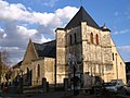
Saint-Etienne church

Porte Saint-Etienne
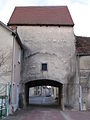
Porte du Pont-Perrin


