Pommiers (Indre)
| Pommiers | ||
|---|---|---|
|
|
||
| region | Center-Val de Loire | |
| Department | Indre | |
| Arrondissement | Chateauroux | |
| Canton | Argenton-sur-Creuse | |
| Community association | Éguzon-Argenton-Vallée de la Creuse | |
| Coordinates | 46 ° 31 ' N , 1 ° 39' E | |
| height | 196-280 m | |
| surface | 12.19 km 2 | |
| Residents | 224 (January 1, 2017) | |
| Population density | 18 inhabitants / km 2 | |
| Post Code | 36190 | |
| INSEE code | 36160 | |
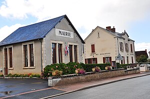
 Town hall (Mairie) of Pommiers |
||
Pommiers is a French municipality with 224 inhabitants (as of January 1 2017) in the department of Indre in the Region Center-Val de Loire ; it belongs to the Arrondissement of Châteauroux (until 2017: Arrondissement La Châtre ) and the canton of Argenton-sur-Creuse (until 2015: Canton of Éguzon-Chantôme ). The inhabitants are called Bazaigeois .
geography
Pommiers is about 38 kilometers south-southwest of Châteauroux . Neighboring communities of Pommiers are Malicornay in the north, Orsennes in the east and south-east, Gargilesse-Dampierre in the south and west, Badecon-le-Pin in the west and north-west and Chavin in the north-west.
Population development
| year | 1962 | 1968 | 1975 | 1982 | 1990 | 1999 | 2006 | 2013 |
| Residents | 418 | 405 | 367 | 322 | 279 | 268 | 270 | 277 |
| Source: Cassini and INSEE | ||||||||
Attractions
- Church of Sainte-Radegonde
- Le Châtelier Castle, Monument historique since 1965/2016
Web links
Commons : Pommiers - collection of images, videos and audio files

