
Gargilesse-Dampierre
| Gargilesse-Dampierre | ||
|---|---|---|
|
||
| region | Center-Val de Loire | |
| Department | Indre | |
| Arrondissement | Chateauroux | |
| Canton | Argenton-sur-Creuse | |
| Community association | Éguzon-Argenton-Vallée de la Creuse | |
| Coordinates | 46 ° 31 ' N , 1 ° 36' E | |
| height | 124-275 m | |
| surface | 42.17 km 2 | |
| Residents | 285 (January 1, 2017) | |
| Population density | 7 inhabitants / km 2 | |
| Post Code | 36190 | |
| INSEE code | 36081 | |
| Website | http://www.gargilesse.fr/ | |

Gargilesse-Dampierre is a French municipality with 285 inhabitants (at January 1, 2017) in the department of Indre in the Region Center-Val de Loire ; it belongs to the arrondissement of Châteauroux and the canton of Argenton-sur-Creuse .
location
The place Gargilesse is located on the right bank of the Creuse at the confluence of the Gargilesse tributary of the same name . Neighboring municipalities of Gargilesse-Dampierre are Badecon-le-Pin in the north, Pommiers in the east, Orsennes and Saint-Plantaire in the southeast, Cuzion in the south, Baraize in the west and Ceaulmont in the northwest.
Population development
| year | 1962 | 1968 | 1975 | 1982 | 1990 | 1999 | 2007 | 2017 |
| Residents | 445 | 400 | 363 | 347 | 342 | 324 | 325 | 285 |
Attractions
- Notre-Dame Church (11th / 12th centuries)
- Castle (10th century)
- Dampierre Church (12th century)
- George Sand's summer home

Gargilesse
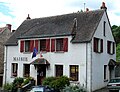
Town Hall (Mairie)
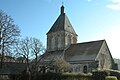
Notre-Dame church

lock
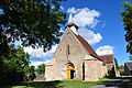
Dampierre Church

George Sand's house


.JPG)


Personalities
- George Sand (1804–1876)
- Pierre Jamet (1893-1991)
Others
Gargilesse is on the list of the most beautiful villages in France .
Gargilesse is a stop on the Way of St. James, Via Lemovicensis , one of the four historical " Paths of the Pilgrims in France "; this is where the north and south routes come together.
literature
- Maria-Garcia Schumacher, L'église Notre-Dame de Gargilesse , in: Congrès archéologique de France. 142nd session. Bas-Berry. 1984 , pp. 117–128, Société Française d'Archéologie, Paris, 1987. [not evaluated]