
Kloesterle
|
Kloesterle
|
||
|---|---|---|
| coat of arms | Austria map | |
 |
|
|
| Basic data | ||
| Country: | Austria | |
| State : | Vorarlberg | |
| Political District : | Bludenz | |
| License plate : | BZ | |
| Surface: | 62.24 km² | |
| Coordinates : | 47 ° 8 ' N , 10 ° 5' E | |
| Height : | 1073 m above sea level A. | |
| Residents : | 677 (January 1, 2020) | |
| Population density : | 11 inhabitants per km² | |
| Postal code : | 6754 | |
| Area code : | 05582 | |
| Community code : | 8 01 12 | |
| NUTS region | AT341 | |
| Address of the municipal administration: |
Klösterle 59c 6754 Klösterle |
|
| Website: | ||
| politics | ||
| Mayor : | Florian Morscher | |
|
Local council : (2015) (12 members) |
||
| Location of Klösterle in the Bludenz district | ||
  |
||
 View of Klösterle in winter 2009 |
||
| Source: Municipal data from Statistics Austria | ||

Klösterle is a municipality with 677 inhabitants (as of January 1, 2020) in the Austrian state of Vorarlberg . The municipality is the capital of the Klostertal and is located in the Bludenz district .
geography
Klösterle is located in the westernmost state of Austria, Vorarlberg, in the Bludenz district at an altitude of 1,073 meters. 27.2% of the area is forested, 30.4% of the area of the Alps (around 11% of which is Alpe Rauz ).
Community structure
The municipality includes the following two localities (population in brackets as of January 1, 2020):
- Kloesterle (591)
- Parlor (86)
The community consists of the cadastral community Klösterle.
The districts of the municipality are Klösterle (415 inhabitants), Langen (69 inhabitants), Stuben (88 inhabitants) and Danöfen (118 inhabitants).
Neighboring communities
Klösterle borders five other municipalities, three of which are in Vorarlberg and two in the neighboring state of Tyrol . From the north clockwise are around Klösterle the communities Lech am Arlberg, Emperor Tyrolean district of Reutte , St. Anton am Arlberg in Tyrol's Landeck district , which in Montafon Located Silbertal and Dalaas , which is just as Klösterle. The municipal areas of Klösterle, Lech, Kaisers and St. Anton am Arlberg meet at the top of the Valluga at 2809 m above sea level. A. , whereby Klösterle only adjoins Kaisers in this one point.
There are well-developed transport connections to the neighboring communities of Lech, St. Anton and Dalaas (to Lech via the Flexenpass or to St. Anton via the Arlbergpass or through the Arlberg road tunnel ). There is no direct road connection to the community of Silbertal, as it is on the other side of the Verwall in the Montafon .
history
The Habsburgs ruled the places in Vorarlberg alternately from Tyrol and Upper Austria (Freiburg im Breisgau). From 1805 to 1814 the place belonged to Bavaria , then again to Austria . Klösterle has belonged to the Austrian state of Vorarlberg since it was founded in 1861. The place was part of the French zone of occupation in Austria from 1945 to 1955.
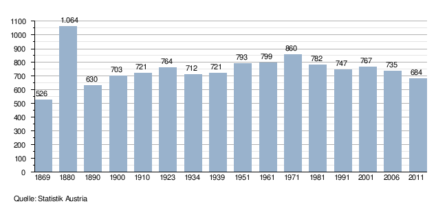
Population development
politics
The community council consists of 12 members. In the 2015 municipal council election, the election was not made by lists, but by majority vote. Florian Morscher has been mayor of the community since 2015.
Culture and sights
- Parish church Klösterle : From 1974 to 1976 the church was rebuilt with the architect Clemens Holzmeister . The steeple of the baroque predecessor church from 1609 was preserved.
- Expositurkirche Langen am Arlberg : The church built with the architect Hans Feßler (1928–1929) gets its unique effect through the refined treatment of the structure. The emblematic form, rising from the slope, is created by the diagonal access. The corner has been developed into a tower, from which the roof runs in a sweeping motion into the slope. The lower components such as walls and steps underline this movement.
- Parish church Stuben am Arlberg : The parish church is structurally connected to a school building in the west.
Economy and Infrastructure
In 2003 there were 47 commercial businesses with 361 employees and 7 apprentices on site. There were 365 employees subject to wage tax. Tourism and tourism are important. In the 2001/2002 tourism year there were a total of 135,098 overnight stays.
traffic

Klösterle has the Langen am Arlberg train station on the Arlbergbahn . This is the last train station on the Vorarlberg side in front of the Arlberg railway tunnel and as a connection to the Arlberg tourist area (here in particular Lech ) a stop for long-distance trains. Until the construction of the Blisadona tunnel, the railway line ran along the slope above the village; the Wäldletobel Bridge, which is now accessible to pedestrians, heralds this.
education
There are (as of January 2003) 35 students on site. There is also a kindergarten in Klösterle.
Personalities
- Anton Ospel (1677–1756), architect and baroque master builder
- Susi Weigel (1914–1990), Austrian children's book illustrator and animator.
- Markus Wolfahrt (* 1960), musician
- Uwe Altenried (* 1961), musician
- Thomas Berthold (* 1962), musician
Individual evidence
- ↑ Statistics Austria: Population on January 1st, 2020 by locality (area status on January 1st, 2020) , ( CSV )
- ↑ Klostertal ( Memento of the original from January 12, 2011 in the Internet Archive ) Info: The archive link was inserted automatically and not yet checked. Please check the original and archive link according to the instructions and then remove this notice.
Web links
- 80112 - Klösterle. Community data, Statistics Austria .

Bartholomäberg | Blons | Bludenz | Bludesch | Fire | Bürs | Bürserberg | Dalaas | Fontanella | Gaschurn | Innerbraz | Klösterle | Lech | Lorüns | Ludesch | Nenzing | Nüziders | Raggal | St. Anton im Montafon | St. Gallenkirch | St. Gerold | Schruns | Silbertal | Sunday | Stallhr | Thuringia | Thuringian Mountain | Tschagguns | Vandans