
Spelled land
 flag |
 coat of arms |
| province |
|
| mayor | John Joosten ( VVD ) |
| Seat of the municipality | Denekamp |
|
Area - land - water |
176.81 km 2 175.77 km 2 1.04 km 2 |
| CBS code | 1774 |
| Residents | 26,342 (Jan 31, 2019) |
| Population density | 149 inhabitants / km 2 |
| Coordinates | 52 ° 22 ′ N , 6 ° 55 ′ E |
| Important traffic route |
|
| prefix | 0541, 074 |
| Postcodes | 7560-7569, 7590-7599, 7630-7639 |
| Website | Homepage of Dinkelland |
 |
|
Dinkelland ( ) is a municipality in the province of Overijssel in the Netherlands . It was created on March 22, 2001 from the merger of the municipalities of Denekamp, Ootmarsum and Weerselo. It has 26,342 inhabitants (as of January 31, 2019). Their total area is 176.81 km².
places

- Denekamp (seat of the municipal administration)
- Ootmarsum
- Weerselo
- Rossum (not to be confused with Rossum near 's-Hertogenbosch )
- Saasveld
- Deurningen
- Noord Deurningen
- Oud Ootmarsum
- Lattrop
- Approved
- 't pen
Location and economy
The municipality forms the north-eastern part of the Twente region . It borders on the Lower Saxon communities of Nordhorn , Lage and Neuenhaus in the county of Bentheim . Denekamp is halfway between Oldenzaal and Nordhorn.
The population lives from tourism and agriculture (livestock farming). Commuters who work in Oldenzaal also live in Denekamp.
history
Denekamp
Denekamp was named Demnichem in a church register from 1276 and was first mentioned as an independent parish with its own church and pastor. From the original first church, after extensions around 1350 and before 1436, the St. Nikolaus Church , built from Bentheim sandstone in the early Gothic style , which underwent major extensions in some cases until the 20th century, such as the addition of a large dome building in 1911 .
Until 1818 Denekamp belonged together with the parishes of Ootmarsum and Tubbergen to the school authority Ootmarsum, when it became an independent municipality together with the villages of Agelo, Breklenkamp, Nutter, Oud Ootmarsum and Lattrop. In 1949, as part of the post-war border corrections, smaller German land areas were added to the municipality of Denekamp. The corrections involved 0.03 km² along the Nordhorn-Almelo Canal for water management from the Rammelbeck and for customs control on the Grensweg. In the 1990s the community lost part of the Klein Angelo farmers to the community of Ootmarsum. On January 1, 2001, the municipalities of Denekamp, Ootmarsum and Weerselo merged to form a new municipality, which was called Denekamp municipality until May 31, 2002 and was named Dinkelland municipality on June 1, 2002.
Ootmarsum
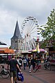
Ootmarsum, called Othmarsheim in the Middle Ages , is said to have been founded in 126 AD by a legendary king, Othmar or Ottmar. What is certain is that the town already existed at the time of the Ottonians and formed a large parish . Around 1300 Ootmarsum was granted city rights by the bishop of Utrecht , it was soon walled and turned into a small fortress . It was at the crossroads of two trade routes, one of which ran from Flanders to Bremen . After Moritz von Nassau had conquered the city for the Protestant Netherlands in 1602 during the Eighty Years War , the fortifications were razed. It fell into disrepair as the development of transport and industry took place elsewhere. Around 1900 the place was recognized as a picturesque cityscape, and some tourism began to emerge. The center was restored in the 1980s.
Weerselo
Weerselo was built around an old monastery and was visited several times by robber knights in the 14th century . They lived in Saasveld on Saterslo Castle, which was demolished in 1818.
Attractions
The center of Ootmarsum with its church and the winding alleys was restored in the 1980s. Located where open-air museum Los Hoes trying from the old Low German hall house - farms to convey an image of the area, was founded in 2004 severely damaged by arson; on March 23, 2005 it was reopened after restoration. To the west of Ootmarsum, where typical Christmas and Easter customs have also been preserved, is a hill that allows a distant view of the town.
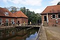
West of Denekamp on the Dinkel (Vechte) river is the 17th / 18th century. Century castle Singraven . It can be visited a few times a week in summer with a guided tour and houses a lot of antique furniture. There is a restaurant by the castle, in an old water mill. This double watermill was painted by Meindest Hobbema as early as the 17th century . The famous picture of this mill hangs in the Louvre in Paris .
Denekamp has the oldest regional natural history museum in the Netherlands. The provincial natural history museum Natura Docet (German: Nature teaches) was founded in 1911 by Meester Bernard Bernink and is now run by a foundation. There is a close cooperation with the Nordhorn Zoo .
In Weerselo there is the district of Het Stift (a former monastery ) with houses from the 18th century and old trees. The collegiate church is the only remnant of a Benedictine monastery from the 12th century. An antique market is held here every Saturday.
The community is crossed by the strongly meandering Dinkel river, where some small streams flow. There are many small forests in Dinkelland. It is one of the few areas in the Netherlands where half-timbered farms (from the 18th and 19th centuries) still stand.
Denekamp, de Sint Nicolaaskerk

Denekamp, mill: de Sint Nicolaasmolen

Denekamp, windmill: Borgelinkmolen

Denekamp, Singraven Estate
Singraven watermill

Denekamp, the Nordhorn-Almelo Canal


Sons and daughters of the church
- Johan Barthold Jongkind (1819–1891), painter
- Willem Hendrik Dingeldein (1894–1953), natural and regional historian
- Piet Stalmeier (1912–1990), musician
- Ton Schulten (* 1938), painter
- Roméo Dallaire (* 1946), Canadian general
- Hennie Kuiper (* 1949), racing cyclist
- Marga Bult (* 1956), singer and television presenter
- Tanja Nijmeijer (* 1978), member of the Colombian guerrilla organization FARC
- Tom Veelers (* 1984), racing cyclist
literature
- Johannes Bernardus Bernink: Ons Dinkelland. Natural history description of Oost-Twente . Museum "Natura Docet", Denekamp, 3rd edition 1926.
- Alinda van Ginkel, Dorien Meijerink: Zo woonden wij, zo leefden wij, 1911-2010. Sociale woningbouw in Dinkelland. Dinkelborgh Wonen, Denekamp 2010, ISBN 978-90-811432-3-3 .
- Wilhelm Horstmeyer: "The bow". Visible sign of the will for an understanding between the city of Nordhorn (D) and the municipality of Dinkelland (NL) . In: Bentheimer Jahrbuch , ISSN 0723-8940 , vol. 2006, pp. 21-32.
- Jan Looms, Henk Frons: Dinkelland . Broekhuis, Enschede 2003.
Web links
- Website of the municipality (Dutch)
Individual evidence
- ↑ Bevolkingsontwikkeling; regio per maand . In: StatLine . Centraal Bureau voor de Statistiek (Dutch)
- ↑ Volkstellingen 1795-1971 Census Register of the Netherlands 1795-1971: Lijst van grenswijzingen (list of border adjustments)
- ↑ International Boundary Study. (PDF) The Geographer Office of the Geographer Bureau of Intelligence and Research, April 6, 1964, archived from the original September 16, 2006 ; accessed on September 17, 2018 (English).
Almelo | Borne | Dalfsen | Deventer | Dinkelland | Enschede | Haaksbergen | Hardenberg | Hellendoorn | Hengelo | Hof van Twente | Kampen | Losser | Oldenzaal | Olst-Wijhe | Ommen | Raalte | Rijssen-Holten | Staphorst | Steenwijkerland | Tubbergen | Twenterand | Wierden | Zwartewaterland | Zwolle