
Almelo
 flag |
 coat of arms |
| province |
|
| mayor | Arjen Gerritsen ( VVD ) |
| Seat of the municipality | Almelo |
|
Area - land - water |
69.40 km 2 67.43 km 2 1.96 km 2 |
| CBS code | 0141 |
| Residents | 72,945 (Jan 31, 2019) |
| Population density | 1051 inhabitants / km 2 |
| Coordinates | 52 ° 21 ′ N , 6 ° 40 ′ E |
| Important traffic route |
|
| prefix | 0546, 074 |
| Postcodes | 7600-7614, 7627 |
| Website | Almelo's homepage |
 |
|
Almelo ( ) is a municipality in the province of Overijssel ( Netherlands ).
history
Almelo developed as a small town around the neighboring castle in the Middle Ages. Almelo Castle, first documented in 1318, was rebuilt in its current form in 1662. It still serves as the residence of the Rechteren-Limpurg family and is not open to the public. In the 17th century, wholesalers in Almelo bought the textiles produced by the many surrounding farming families who worked at home. When the steam engines arrived in 1830 , large textile factories developed from them, and Almelo became a medium-sized industrial city. Similar to Hengelo and Enschede , this industry declined sharply after the Second World War .
The current municipality of Almelo was newly formed on January 1, 1914 through the merger of the previous municipalities of Ambt Almelo and Stad Almelo .
During the Second World War, Almelo was badly damaged by fighting in March 1945. A year later, this resulted in a flood without any fatalities: the locks and dykes in the surrounding waters had not yet been repaired.
Infrastructure and economy
The city has an Arrondissementsrechtbank (comparable to a German regional court ). There are also various cultural institutions and a hospital.
traffic

The Almelo Station is located near railroad tracks Deventer-Almelo , Zwolle-Almelo , Mariënberg-Almelo and Almelo-Salzbergen . Supraregional connections exist via the Amsterdam - Apeldoorn - Deventer - Hengelo - Osnabrück - Berlin line . Local railways connect Almelo via Raalte with Zwolle and Mariënberg . Almelo is connected to the A1 / E30 motorway Amsterdam - Apeldoorn - Berlin (in Germany BAB30 ) by a junction .
economy
A large industrial area is located in the northwest of the city, where several canals meet at the inland port. After the collapse of the textile industry (1950 to 1975), medium-sized companies of all kinds settled here thanks to state subsidies . A factory produces parts for nuclear power plants (Ultra Centrifuge Nederland), and the only uranium enrichment plant in the Netherlands is located here . The company Urenco plans to expand this facility. The PANalytical based in Almelo is a global manufacturer of X-ray systems.
The village of Bornerbroek, west of the city, has been part of Almelo since 2001. In Bornerbroek, a large industrial park should be developed in 2006 or 2007, the plan is highly controversial among environmentalists in the region.
photos

Catholic Church of Mary of Perpetual Help , neo-Gothic
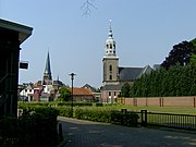
Towers of the Catholic Basilica of St. George (left) and the Protestant Grote Kerk (right)

Protestant Grote Kerk, choir made of sandstone and tuff Gothic
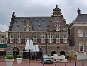
Almelo, Old Libra building


Sports
Almelo has been the venue for the Wielerklassieker De Hel van Twente every year since 1988 . The city's largest football club , Heracles Almelo , plays in the honor division , the highest class of professional football, and has a stadium with artificial turf . In addition, Almelo has a wide range of sports facilities for a wide variety of sports.
Town twinning
The municipality of Almelo maintains a twinning relationship with the city of Iserlohn in Germany and with Denizli in Turkey , Preston ( England ), Biel / Bienne ( Switzerland ) and Kortrijk ( Belgium ).
sons and daughters of the town
- Azra Akin (* 1981), Miss World 2002
- Joyce van Baaren (* 1984), Taekwondo athlete
- Evert Willem Beth (1908–1964), logician
- Jacob Maarten van Bemmelen (1830–1911), chemist
- Cornelia Bouman (1903–1998), tennis player
- Wout Brama (* 1986), football player
- Hero Brinkman (* 1964), Dutch politician
- Arnold Bruggink (* 1977), soccer player
- Hendrik Cock (1794–1866), legal scholar and politician
- Anouk Dekker (* 1986), soccer player
- Ilse DeLange (* 1977), one of the most successful Dutch pop singers
- Elbert Dijkgraaf (* 1970), economist and politician (SGP)
- Herman Finkers (* 1954), comedian who speaks partly in Twents in his shows
- Bertus Freese (1902–1959), national soccer player
- George de Jong (* 1953), volleyball player and coach
- Hendrik Krüzen (* 1964), football player
- Dennis Kuipers (* 1985), rally driver
- Mark Looms (* 1981), soccer player
- Bill Minco (1922-2006), resistance fighter and local politician
- Philipp Christiaan Molhuysen (1870–1944), librarian at the Royal Library of the Netherlands
- Peter Müllenberg (* 1987), amateur boxer
- Wubbo Ockels (1946–2014), physicist and spaceman
- Barbara Snellenburg (* 1975), photo model and mannequin
- Berdien Stenberg (* 1957), flautist
- Peter Tiehuis (* 1956), guitarist
- Michiel Veenstra (* 1976), radio DJ
- Kirsten Wild (* 1982), racing cyclist
Web links
- Website of the municipality (Dutch)
Individual evidence
- ↑ Bevolkingsontwikkeling; regio per maand . In: StatLine . Centraal Bureau voor de Statistiek (Dutch)
Almelo | Borne | Dalfsen | Deventer | Dinkelland | Enschede | Haaksbergen | Hardenberg | Hellendoorn | Hengelo | Hof van Twente | Kampen | Losser | Oldenzaal | Olst-Wijhe | Ommen | Raalte | Rijssen-Holten | Staphorst | Steenwijkerland | Tubbergen | Twenterand | Wierden | Zwartewaterland | Zwolle