
Folkušová
| Folkušová | |||
|---|---|---|---|
| coat of arms | map | ||

|
|
||
| Basic data | |||
| State : | Slovakia | ||
| Kraj : | Žilinský kraj | ||
| Okres : | Martin | ||
| Region : | Turiec | ||
| Area : | 6.013 km² | ||
| Residents : | 144 (Dec. 31, 2019) | ||
| Population density : | 24 inhabitants per km² | ||
| Height : | 520 m nm | ||
| Postal code : | 038 42 (Post Office Príbovce ) | ||
| Telephone code : | 0 43 | ||
| Geographic location : | 48 ° 58 ' N , 18 ° 57' E | ||
| License plate : | MT | ||
| Kód obce : | 512257 | ||
| structure | |||
| Community type : | local community | ||
| Administration (as of November 2018) | |||
| Mayor : | Milan Sopóci | ||
| Address: | Obecný úrad Folkušová č. 11 038 42 Folkušová |
||
| Website: | www.folkusova.sk | ||
| Statistics information on statistics.sk | |||

Folkušová ( Hungarian Folkusfalva ) is a municipality in the north- central part of Slovakia with 144 inhabitants (as of December 31, 2019) and part of Okres Martin in Žilinský kraj in the Turz region .
geography
The municipality is located in the eastern part of the Turčianska kotlina basin at the transition to the Great Fatra . The town center is at an altitude of 520 m nm and is 16 kilometers from Martin .
history
Folkušová was first mentioned in writing in 1331 as villa Folkus . Other names were Folco Villa (1355), Folkusfalua (1359), Ffolkasfalwa (1391), Folkusovalva (1552), Folkosfalua Zobozlo olim (1736), Folkussowa (1773). In 1785 359 people lived in 62 houses. In 1828 there were 248 inhabitants in 30 houses, who were mainly engaged in agriculture. In addition, some artists and craftsmen, furriers, weavers and basket weavers lived in the village.
population
Results after the 2001 census (122 inhabitants):
|
By ethnicity:
|
By denomination:
|
Culture
Web links
- E-obce.sk (Slovak)
- Folkusfalva Szlovákia térképén (Hungarian)
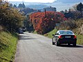
Folkušová (summer)
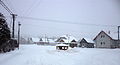
Folkušová (winter)

Flag of Folkušová


