Vrútky
| Vrútky | ||
|---|---|---|
| coat of arms | map | |

|
|
|
| Basic data | ||
| State : | Slovakia | |
| Kraj : | Žilinský kraj | |
| Okres : | Martin | |
| Region : | Turiec | |
| Area : | 18.656 km² | |
| Residents : | 7,748 (Dec. 31, 2019) | |
| Population density : | 415 inhabitants per km² | |
| Height : | 382 m nm | |
| Postal code : | 038 61 | |
| Telephone code : | 0 43 | |
| Geographic location : | 49 ° 7 ' N , 18 ° 55' E | |
| License plate : | MT | |
| Kód obce : | 557358 | |
| structure | ||
| Community type : | city | |
| Administration (as of November 2018) | ||
| Mayor : | Branislav Zacharides | |
| Address: | Mestský úrad Vrútky Matušovičovský rad 4 03861 Vrútky |
|
| Website: | www.vrutky.sk | |
| Statistics information on statistics.sk | ||
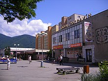
Vrútky (until 1927 "Dolné Vrútky a Horné Vrútky"; German Ruttek , Hungarian Ruttka ) is a city in central Slovakia .
geography
location
The city is located at the mouth of the river Turz in the Waag below the Little Fatra , about 3 km north of Martin and 25 km east of Žilina . Is also in the vicinity of the Greater Fatra National Park ( Narodny park Velka Fatra ) and the city is home to its management.
Districts
- Hluchovo
- Karvaša
- Blahovca
population
Most of the Hungarian railway workers left the city after 1919. As a result of the Second World War, there is no longer a German or Jewish population.
At the 2001 census, the city had 7,298 inhabitants, of which 96.01% Slovaks, 1.33% Czechs, 0.47% Gypsies and 0.33 Magyars. According to religious affiliation, 50.34% were Roman Catholics, 24.86% without religious affiliation and 19.01% Protestant.
history
The place was first mentioned in writing in 1255 as villa Vrutk .
Already at the end of the 13th century a distinction was made in the records between Dolné Vrútky and Horné Vrútky. The place was shaped by agriculture for a long time. In 1869, 917 people lived here.
In the course of the construction of the railway lines Žilina – Košice (1871) and Zvolen – Vrútky (1873), new branches of industry emerged and there was an upswing. The railway workshops are especially important for the city.
In 1901 there were 4,345 mostly Slovak and German residents (Roman Catholic and Protestant denominations) in the town. In 1910 there were already 6249 inhabitants.
Until 1918 Vrútky belonged to Turz County in the Kingdom of Hungary . Through the Treaties of Trianon, the place came to the newly formed Czechoslovakia and then from March 14, 1939 to the independent Slovak state.
In 1921 Vrútky had 6807 inhabitants in 637 houses, of which 5712 were Slovaks , 359 Magyars , 266 Jews and 252 Germans .
At the end of the Second World War, the city was captured by the Czech-Slovak brigades on April 11, 1945.
From 1949 to 1954 and 1971 to 1990 the community was merged with the neighboring town of Martin , and since 1990 it has had town status.
It has been part of Slovakia since 1993 .
Attractions
- Gothic church from 1285, rebuilt in 1905 in neo-Gothic style
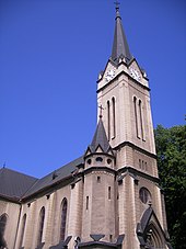
- neo-Gothic Evangelical Luther Church (1903)
- Synagogue (1910)
- Town Hall (1926)
traffic
Vrútky station is an important railway junction. Originally it was the junction of the Kaschau-Oderberger Railway and the Ruttka-Budapest railway line , today's Salgótarján – Vrútky railway line .
education
At the moment there is a middle school, 2 elementary schools, 1 leisure center and 4 kindergartens in the village.
Sports
- Soccer: TJ Lokomotíva Vrútky
- Tennis: TK Vrútky
- Street hockey : Kometa Vrútky
Town twinning
- Nymburk ( Czech Republic )
- Fulnek (Czech Republic)
- Bebra ( Germany )
- Łaziska Górne ( Poland )
Personalities
- John Daniel Hertz (1879–1961), businessman
- Stanislav Landa (1898-1981), chemist
- Arpád Tesár (1919–1989), civil engineer
- Radoslav Brzobohatý (1932–2012), actor
- Adolf Scherer (* 1938), football player
- Vladimir Weiss (1939–2018), football player
- Rastislav Špirko (* 1984), ice hockey player


