Golmberg
| Golmberg | ||
|---|---|---|
|
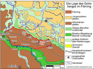
The location of the Golmberg in Fläming. |
||
| height | 178 m | |
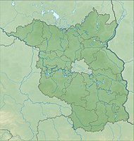
| location | Nuthe-Urstromtal municipality ( Brandenburg , Germany ) | |
| Mountains | Flaming | |
| Coordinates | 52 ° 0 '59 " N , 13 ° 20' 33" E | |
|
|
||
| Type | Terminal moraine | |
| rock | Debris , gravel , sand , boulder clay | |
| Age of the rock | approx. 140,000 years | |
The 178 meter high Golmberg is the highest point in the Niederer Fläming ridge . It is located in the district of Stülpe (municipality Nuthe-Urstromtal , Teltow-Fläming district , state of Brandenburg ) and borders on a former Soviet military site. Today the mountain is part of the Heidehof-Golmberg nature reserve .
Geographical overview and geology
The Golmberg is part of a smaller ridge with seven peaks, which are also known collectively as the Golmberg. With this name, the highest of these peaks, the Golmberg, bears the name "Großer Kirchberg" to distinguish it. While the Golmberg, seen from the north, rises only slightly from the forest hills of the Niedere Fläming, seen from the south, it marks the border of the lowland landscape of the Flemmingwiesen in the Glogau-Baruther glacial valley south of the village of Stülpe and the city of Baruth . The difference in altitude to the level of the glacial valley is around 120 meters over a distance of only 1 kilometer. This makes it one of the areas with the highest relief energy in Brandenburg.
The Golmberg area is interpreted today as part of the Werbig-Petkuser-Staffel as a terminal moraine from the Saale Ice Age. Since there are hardly any current geological boreholes due to military history, it is assumed, in analogy to neighboring areas, that the material from which the Golmberg is made was intensely compressed (disturbed) by the pressure of the inland ice . The Golmberg area itself mostly consists of sands and subordinate glacial till . As part of the old moraine landscape on the Golmberg, there are numerous winds that arose during the recent Vistula Ice Age , when the area was free of ice, but hardly overgrown with plants due to the cold climate. Only 1.5 to 2 kilometers north of the Golmberg, the Weichselian inland ice reached its maximum extent to the south. The Baruther glacial valley already belongs to the young moraine land .
The formation by terminal moraines made the Golmberg “extremely rich”. Between Golmberg and Merzdorf a continuous train of bed load stretches along the terminal moraine. Despite the removal of many stones for building roads, churches and houses, there are still numerous boulders in the forest. Outstanding boulders in the Golm area are the “Spitz Stein” in Jagen 101, about 500 m east of the Golmberg, with a circumference of 6.50 m and a height of 1.50 m, the “Wildsuhlenstein” with a circumference of 7 m and a height of 1.50 m "Blue Cow", "Blue Calf" and "Kanzelstein" in Jagen 84, between the summit and the earlier route from Lynow to Petkus (there is a legend that the pilgrims preached from here before the Reformation). Another, smaller boulder made of reddish granite stands at the remains of the foundations of the former refuge west of the summit.
The original vegetation of the Golmberg ridge is oak forest; in 1796 50,000 strong oaks were counted in the Golmforst. Around 1910 the slopes were reforested with pine trees.
While the view to the south behind Ließen and Petkus is limited by the hilltops of the Fläming, the Golmberg around 1900 offered a wide view to the northwest, north and northeast, which in particularly clear weather extended to Berlin and Potsdam (50–60 kilometers); Hiking book authors in the 1920s described the Golmberg as the "Markische Rigi ". After 1990 the last, up until then unwooded, knolls grew over with oak, pine and sloe growth, so that today there is only a sparse view in the winter months.
Heidehof-Golmberg nature reserve
|
Heidehof-Golmberg
|
||
| location | Brandenburg , Germany | |
| surface | 98.336 km² | |
| WDPA ID | 318516 | |
| Geographical location | 52 ° 1 ' N , 13 ° 18' E | |
|
|
||
| Setup date | December 30, 1999 | |

Due to the previous use as a military training area for the Red Army , the Heidehof-Golmberg nature reserve is characterized by large open and succession areas, which are supplemented by areas used for forestry, especially in the golf area. Together with the neighboring NSG Forst Zinna Jüterbog-Keilberg, the entire area immediately north of the Golmberg, which is already part of the Baruther glacial valley, is one of the most representative drifting sand and inland dune areas in Germany.
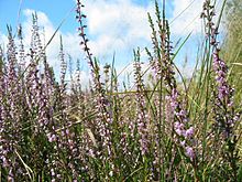
According to the soil conditions prevail on the 12,000 hectare and uninhabited reserve undemanding sand heaths before that mainly of silver grass ( Corynephorus canescens ), heather ( Calluna vulgaris ) and various broom ( Genista composed). Birch and pine trees are characteristic of the foothills , and the remains of richly structured oak and red beech forests exist on the mountain .
The barren soil is home to the typical ground beetle and grasshopper fauna , specialized and rare species of insects and spiders . In the older oak stands the endangered large oak buck or giant buck ( Cerambyx cerdo ), which the forestry had long classified as a pest . This imposing longhorn beetle , whose bent-back antennae can reach a length of ten centimeters in males, is now strictly protected under the EU's Habitats Directive . The large and rare stag beetle ( Lucanus cervus ) also lives in the Golm oak forest. Various birds of prey and 14 species of bats are native to the area.
history
Origin of name
The place or field name Golm appears several times in East Germany and is derived from the Slavic word for mountain or hill. The root of the word is certainly even older (see Kulm (geography) ).
Marienkapelle and Golmberg treasure
In the Slavic times, a Wendish sanctuary in the form of a column is said to have stood on the summit , which supposedly gave the place its name to Stülpe , because post, column means stolp in Slavic . As far as we know today, this assignment cannot be maintained, because the posts that gave it its name stood by a silted-up lake north of the village and first mentioned in 1221. Since 2005 the summit of the Golmberg has been crowned with a pilgrimage cross, which reminds of the former pilgrimage site with a Marienkapelle of the monastery Zinna (located between Luckenwalde and Jüterbog on the B 101 ). The Cistercian chapel from around 1435 was completely demolished after the Reformation , its two Gothic winged altars and the bell from 1498 were moved to the church in nearby Stülpe and can be viewed there.
The legend that he financed the construction of the castle by raising the Golmberg treasure is associated with the preserved Stülper Castle from 1754 and its builder Adam Ernst von Rochow from the Brandenburg nobility family von Rochow from the Zauche . The monastery monks allegedly buried this treasure on the mountain - what is certain is that the monks made considerable profits from the pilgrimages to their mountain chapel, and it is also guaranteed that his predecessor as lord in Stülpe, Friedrich Wilhelm von Rochow , came from a treasure digger with a divining rod , Devices and all sorts of hocus-pocus to search for the treasure.
Attack in the Golmheide

Church sources of income also played a historical role on the Golmberg in the 16th century, in this case in the form of the indulgence trade and its protagonist Tetzel . Hans von Hake (1472–1541) from the von Hake family , who resided in Kleinmachnow and preceded the Rochows in Stülpe, was involved in this incident . Theodor Fontane describes this incident in his hikes through the Mark Brandenburg :
"It was this hook von Stülpe who attacked the indulgence merchant Tetzel on the Golmheide between Jueterbogk and Trebbin and, under the sneering pretense of" having bought the indulgence slip for sins yet to be committed from him yesterday ", took the whole cash and the box from him rolled downhill in the snow. "
The founder of historical realism in German literature and Fontane's predecessor as a Brandenburg writer, Willibald Alexis , also dedicated a section to the incident in the 1847 novel The Werewolf . The stolen box (the " Tetzelkasten ") has been in the Church of St. Nikolai (Jüterbog) ever since . However, some other cities have a "tetzel box" or are woven into legends around the box.
It is actually unlikely that the attack took place in the form described, as Hans von Hake did not acquire the nearby village of Stülpe until 1537, many years after Tetzel's death, and would only have had to ride 45 km from Kleinmachnow to Golmheide to attack Tetzel there.
Land survey
Its outstanding location made the Golmberg a central point of the Prussian land survey in the 19th century. Around 1868 a first-order trigonometric point was marketed here . Until the land surveying was switched to satellite data in the 1990s, the Golmberg played an important role in surveying. Around 1900 light signals were exchanged at night over a distance of 103 km between the tower on the Golmberg and the 23 m above ground visitor gallery of the Kaiser-Friedrich-Tower on the 119 m high Pimpinellenberg near Oderberg .
The trigonometric point was marked with a 40 m high wooden frame that was visible from afar. While climbing the scaffolding was forbidden until the early 1920s, it could be climbed on ladders until the middle of the 1920s. Until the 1990s, increasingly ruinous wooden scaffolding stood on the summit.
The granite landmark of the trigonometric point has been preserved to this day. It is only a few steps away from the remains of a shelter or small bunker, presumably of Soviet origin, on the summit.
Hiking destination
Its outstanding location made the mountain a hiking destination early on. As early as 1825, the owner of Stülpes, Adolf FA von Rochow , had an approximately 12 m high (wooden?) Lookout tower built, from which the towers of Wittenberg, 52 km away and 87 km away, can be seen with a telescope supposedly over the Fläming Heights Collmberg near Oschatz, the Spremberg, which is also 87 km away, and the slopes of the Oderbruch around Bad Freienwalde, which are 80–100 km away. In 1888 the dilapidated tower was rebuilt, but two years later it fell victim to a fire. In 1867 and 1868, at the time of the founding of the German Empire , and in 1895, patriotic festivals were held on the Golmberg. The popularity of the mountain may have been due to the fact that the slopes were cleared at the time of the Wandervogel around 1910 and the view was open even without a tower. The hikers called the summit "Hoher Golm". In 1909 there was a refuge about 50 m west of the crest, of which only remains of the foundations have survived.
Current situation
From 1952 to 1994 at the latest, the Golmberg belonged to a military training area of the Soviet Army and was completely closed to civilians.
Today the metal radio mast, which has been standing a little below the actual summit for decades (used by Telekom after the fall of the Wall ), characterizes the image on the mountain, in the immediate vicinity of which the building of the former main radio control center of the NVA's narrow-band radio network is located. The area with the building and the mast itself are not accessible. Areas and paths marked by posts are intended to guide the hiker through the former military area. However, use is at your own risk, as it cannot be ruled out that, for example, residues of live ammunition may still remain on the mountain slopes.
Tourist use
Located close to circuit 1 of the Flaeming-Skate between Stülpe and Ließen, the landscape around the Golmberg, partly with mixed oak forest, is a hiking destination. It is worth mentioning that even at the time of the fall of the Wall (GDR and post-reunification), local people from Ließen were already hiking once a year around the mountain to the summit. Regular stops were also the Predigtstein , the Wolfsgrube and the Golmquelle . The wolf pit near the former refuge is probably the only surviving Brandenburg. The Golm spring rises in a valley floor on the northern slope of the mountain, soon seeping back into the pine forest. The old Luther oak on the summit fell over in 2010; their trunk can still be seen.
literature
- Jan Feustel : Between watermills and swamp forests. A travel and adventure guide to the Baruther glacial valley. Hendrik Bäßler Verlag, Berlin 1999, ISBN 3-930388-11-1 , pp. 52, 70 f.
- Theodor Fontane: Walks through the Mark Brandenburg. Part 4: Spreeland. Frankfurt a. M./Berlin 1998, ISBN 3-548-24381-9 , quotation on p. 310 f.
- Willibald Alexis : The werewolf. Kaatsch in the Gutenberg-DE project ; with Alexis the Golmberg is called Golenberg .
Web links
- HU Berlin, on the geology and geomorphology of the area
- historical table sheet "Luckenwalde" from the Deutsche Fotothek (Golmberg area, western part, scale 1: 25,000)
- historical table sheet "Paplitz" from the Deutsche Fotothek (Golmberg area, eastern part, scale 1: 25,000)
Footnotes
- ↑ In Hohen Fläming to the west , the 200 meter high Hagelberg is the highest point.
- ^ Author collective: Nature and nature conservation in the Potsdam district. Edited by the Potsdam District Council, Agriculture and Forestry Department - District Nature Conservation Administration, Potsdam 1958, p. 204 f. and p. 211.
- ↑ Eberhard Scholz: The natural spatial structure of Brandenburg. Published by the Pedagogical District Cabinet Potsdam 1962, p. 16.
- ↑ Paula Foerster: The Brandenburg traveling comrade, Volume 1: The South. Hugo Bermühler Verlag Berlin undated (around 1930), p. 31.
- ↑ Handbook of Historic Places in Germany, Volume X: Berlin-Brandenburg. Alfred Kröner Verlag Stuttgart 1995, ISBN 3-520-31103-8 , p. 317 f., Keyword “Stülpe”; as well as Dieter Mehlhardt: Märkische Dorfkirchen 150: Stülpe. In: Potsdam Church No. 4/1985.
- ↑ https://upload.wikimedia.org/wikipedia/commons/5/51/Die_Dreieckpunkte_I._Ordnung_der_Trigonometrischen_Abtheilung_der_K%C3%B6nIGE_Preu%C3%9Fischen_Landesaufnahme.jpg
- ↑ a b Alfons Girzalsky: The Werbellin. History of the heather, the lake and the surrounding area. Neu-Fehlefanz at Velten 1931, p. 50
- ↑ a b c d e Emil Albrecht: hiking book for the Mark Brandenburg and adjacent areas, second part: further area around Berlin, western half. Alexius Kießling Buch- und Landkartenverlag, Berlin 1910, p. 31. Albrecht calls the exchange of signals "Telefunken attempts".
- ↑ Kiessling's hiking book for the Mark Brandenburg, 4th part: The south. Carl Flemming et al. CT Wiskott AG, Berlin 1925, p. 133.
- ↑ Straubes travel guide through the province of Brandenburg - Märkisches Wanderbuch with neighboring areas of Mecklenburg a. Anhalt, Volume II. Geographical Institute and Map Publishing House Jul.Straube, Berlin 1929, p. 97.
- ↑ a b Details of the visual targets according to the province of Brandenburg in words and pictures. Edited by the Pestalozzi Association of the Province of Brandenburg. Published by Julius Klinkhardt, Berlin 1900, reprint in Weltbild Verlag Augsburg 2001, ISBN 3-86047-209-7 , p. 431; Tower history ibid., P. 432.
- ↑ Gustav Albrecht: Straubes Märkisches Wanderbuch - Excursions in the Mark Brandenburg, Part II , Geographical Institute and map publisher Jul. Straube, Berlin 1909, p. 54 f.
- ↑ Hans Scholz : Walks and trips in the Mark Brandenburg, Volume 3. Stapp Verlag Berlin 1975, ISBN 3-87776-521-1 , p. 163 f. The letter writer there dated his hike to Golmberg, which was stopped by tanks, more than 20 years ago; Since the GDR on May 26, 1952 with the "Ordinance on Measures on the Demarcation Line between the German Democratic Republic and the Western Occupation Zones" banned West Berliners from entering the GDR with effect from June 1, 1952 (Pentecost Sunday), this hike must take place before Pentecost 1952 have taken place, from which it follows that in 1952 Soviet soldiers were already standing on Golmberg.
- ↑ Paula Foerster: The Brandenburg traveling comrade, Volume 1: The South. Hugo Bermühler Verlag Berlin undated (around 1930), p. 104 f.


