Hage
| coat of arms | Germany map | |
|---|---|---|

|
Coordinates: 53 ° 36 ' N , 7 ° 17' E |
|
| Basic data | ||
| State : | Lower Saxony | |
| County : | Aurich | |
| Joint municipality : | Hage | |
| Height : | 1 m above sea level NHN | |
| Area : | 16.62 km 2 | |
| Residents: | 6272 (Dec. 31, 2019) | |
| Population density : | 377 inhabitants per km 2 | |
| Postal code : | 26524 | |
| Area code : | 04931 | |
| License plate : | AUR, NOR | |
| Community key : | 03 4 52 008 | |
| LOCODE : | DE 76J | |
| Community structure: | 3 districts | |
| Address of the municipal administration: |
Main street 56 26524 Hage |
|
| Website : | ||
| Mayor : | Erwin Sell ( SPD ) | |
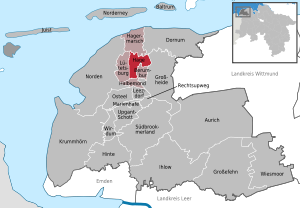
| Location of the municipality of Hage in the Aurich district | ||
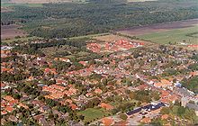
The patch Hage ( East Frisian : Haag ) is a municipality and the administrative seat of the joint municipality Hage in East Frisia .
geography
Hage is a street settlement on a former sea dike on the northern edge of the East Frisian Geest between the north and Arle . In the upstream marsh , the Hager Tief flows along the Geestrand , and branching off from it further west of the town, the Marschtief runs in a south-north direction, already at the level of the town of Lütetsburg . In the eastern city Berum and the western Lütetsburg there was chieftain seats . There was a castle in the western Hage.
history
First traces of settlement and the high Middle Ages
Hage was probably built at the end of the 12th century on an old trade route from the Bronze Age. The first settlements were found on the so-called “Hagherweg”: Hilgenbur and Vnuggenbur.
In the early 13th century there are reports of monastic life in Hage. Initially a Benedictine monastery was built, but the existence of the St. Anne's monastery, which was probably abandoned in 1235, cannot be clearly proven. From the middle of the 13th century, the nuns were followed by a Dominican monastery .
The Ansgari Church was completed around 1250 . To this day it dominates the townscape of the patch.
Late Middle Ages
However, Hage was first mentioned in a document after 1400 as Haghene, Hagha or Haghe, which means something like "closely related". The name Hage can be found for the first time in the East Frisian document book around 1410.
The East Frisian noble family Hinkena is of particular importance for the development of the place. With her castle, the west wing of which can still be seen today, she secured the old trading center of Hage. In 1466 the castle and the lands belonging to it became the property of the church and for many centuries served to finance a second pastor in Hager, the so-called Westerpastorei.
17th and 18th centuries
In the 17th century prosperity moved into Hage, which lasted until around 1715 and disappeared again in the storm surge year 1717 (Christmas flood, 2800 deaths in East Frisia ). Hage also received market rights in 1656 and from then on could call itself “market town”. According to the princely charter awarded at the time (September 11, 1656), Hage was allowed to hold two markets per year. This tradition continues to this day.
19th century
In the early 19th century (1817-1819) Hage received a paved stone road for the first time. Where previously there was only a narrow, tree-lined and often hardly passable “Hagherweg”, the new road was built with the help of a Dutch road construction company.
Another building that dominates the townscape is the eight-story Hager Windmühle , an eight-sided gallery Dutch with a five-story brick substructure. With a height of 30.20 meters to the top of the cap, it is today the tallest windmill in Germany and one of the tallest in Europe. It was built in 1872/73 and after a fire in 1880 one floor was added.
1900-1959
At the end of 1914, the Imperial Navy built the Hage airship port due to its strategic location immediately north of the village, which was completed by 1915 with four large airship hangars. Hage was one of the main attack bases of the airships against Great Britain in the First World War . In 1917, the airships were moved further inland due to increasing air attacks by Allied airmen. The halls had to be demolished in 1921 in accordance with the provisions of the Versailles Treaty . The area was used again by the Luftwaffe from 1937.
1960 until today
Along with a structural change at the beginning of the 1960s, the share of the labor force in agriculture fell to 30.2 percent in 1961 and to 26.1 percent in 1965. Small family farms disappeared rapidly. New roads and farm roads were built and the first wind turbines to generate electricity were installed. In October 1963 the new town hall was inaugurated. In 1965, Hage merged with Berum, Blandorf-Wichte, Lütetsburg and Westdorf to form the joint municipality of Hage . After both the passenger traffic of the Deutsche Bundesbahn in 1983 and the freight train operation in 1989, an operator association for the museum train coastal railway East Friesland was founded. This museum train now stops at the former Hager train station.
In the 1980s and 1990s, Hage developed into a rural center with shopping and leisure areas. In 2006 the former Hager train station, which was damaged by the fire in the roof structure, was demolished. In the same year the construction of the relief road began, which was completed in 2010.
Incorporations
On July 1, 1972, the communities Berum and Blandorf-Wichte were incorporated into the Hage area.
Religions

-
Churches
- Evangelical Lutheran St. Ansgari Church (Hage)
- Roman Catholic parish of St. Ludgerus (St. Wiho church, branch of the northern parish)
-
Free Churches
- The Free Evangelical Community of Hage dissolved in 2006. Its former members now belong to the Free Evangelical Congregations in Norden (East Frisia) and Aurich .
- Other religious communities
politics
Municipal council
The council of the municipality of Hage consists of 18 councilors and councilors. This is the specified number for the member municipality of an integrated municipality with a population between 6001 and 7000 inhabitants. The 18 council members are elected by local elections for five years each. The current term of office began on November 1, 2016 and ends on October 31, 2021.
The municipal council elected councilor Erwin Sell (SPD) as honorary mayor for the current electoral term.
The last local election on September 11, 2016 resulted in the following:
| Political party | Proportional votes | Number of seats | Change voices | Change seats |
|---|---|---|---|---|
| SPD | 59.50% | 11 | −1.75% | +1 |
| CDU | 31.31% | 6th | + 4.37% | +1 |
| Alliance 90 / The Greens | 9.18% | 1 | −2.62% | −1 |
The turnout in the 2016 local elections was 59.11%, above the Lower Saxony average of 55.5%. For comparison - in the previous local election on September 11, 2011, the turnout was 54.32%.
mayor
Erwin Sell has been the honorary mayor of Hage since May 8, 2008 . The local council re-elected him to the mayor's office for the 2016–2021 electoral term.
coat of arms
The coat of arms of the Hage patch was adopted as the coat of arms of the joint community when the Samtgemeinde Hage was set up . The colors are blue-gold. The colors are identical to those of the city of Norden and indicate that the municipality is part of the Norderland .
Culture and sights
Attractions
The St. Ansgari Church dates from around 1220. The late Gothic choir was added at the end of the 15th century. Dirk Lohman built the organ from 1776–1783 using pipe material from the 17th century.
The Hager mill from 1873/1880 is a gallery Dutch mill . At 30.20 meters to the top of the cap, it is the highest mill in East Frisia and all of Germany. Predecessors were the wooden post mill , which was built around 1597 and demolished in 1852, and the column mill from 1852/1853, which was destroyed by fire in 1872. The Hager windmill was originally built by Claas Hinrich Bruns in 1873 and was partially destroyed by lightning in 1880, but was then rebuilt and given an additional floor. In 1931/1932 a storage facility and the wheat mill were added. Wheat processing had to be stopped in the 1960s due to unprofitability. In 1965, Schelten-Peterssche Vermögensverwaltung took over the Hager windmill and its outbuildings and began renovating it in 1995. After extensive restoration, the windmill was given a new cap on August 15, 1997, and the wing cross also turned again. The wings have meanwhile been dismantled, the canopy no longer automatically turns into the wind.
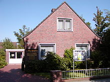
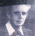
The Magda-Heyken-Haus houses a local history collection about the town of Hage and the surrounding area. The house of the chronicler Magda Heyken , built in 1959, was given to the Flecken Hage as a gift in 1972 on condition that a home archive be set up here. The opening took place in 1986. Today the Magda-Heyken-Haus houses historical files, documents, photos and paintings from Hage and the surrounding area. There is also a library and a local collection here. The community director Udo Backer , who died in 1988, provided a true-to-original model of the Alt-Hage from 1872.
Hager low
In 1934/1935 the Hager Tief was expanded by the North Drainage Association to improve drainage. The work was carried out in painstaking detail with simple spades.
Sports
- SV Hage (football, ballet, table tennis, handball, gymnastics, volleyball, dodgeball)
- Unity Hage (Boßeln / Klootschießen)
Economy and Infrastructure
Public facilities
- Spa center with holiday park in Berum
education
- Cooperative comprehensive school Hage
- Elementary School Hage
traffic
Hage had a connection to the East Frisian Coast Railway, which ran from Emden via Norden, Dornum, Wittmund, Jever and Sande to Wilhelmshaven. On the section north - Dornum, which is run as a museum railway, from May to October on Sundays and public holidays special trains of the association MKO e. V.
Personalities
Sons and daughters of the place
- Elisabeth Allmers (* 1930), b. Büttger, German publisher
- Friedrich Arends (1782–1861), geographer and cultural historian
- Udo Backer (1924–1988), municipal director
- Gerhard Bolt , first mayor of the municipality (picture with Willy Brandt see below)
- Weert Canzler (* 1960), social scientist and mobility researcher
- Jan Cornelius (* 1953), songwriter
- Jürn Cornelius (* 1957), German musician and actor
- Hendrik Deijman (* around 1700), lower corporal with the Dutch East India Company
- Johann Diederich Deimann (1731–1783), Dutch Protestant preacher
- Johan Rudolph Deiman (1743–1808), German-Dutch physician and chemist
- Hermann Dinkla (* 1943), German politician (CDU)
- Ralf Ewen (* 1972), German soccer player
- Hans-Werner Fischer-Elfert (* 1954), German Egyptologist
- Gitta Franken (* 1959), Low German author and songwriter
- Magda Heyken (1895–1972), chronicler
- Frieda Klein (1944–1963), fatality on the inner-German border
- Edo Friedrich Peterssen (1827–1900), member of the Reichstag from Berum
- Hardy Pundt (* 1964), geospatial scientist and writer
Personalities who have worked on site
- Dieter Eilts (* 1964), German footballer
- Bartholomäus Meyer (1644–1714), Lutheran pastor
- Theodor J. Reisdorf (1935–2015), German crime writer
- Carl-Edzard Schelten-Peterssen (1921–1995), German politician (NSDAP, CDU)
- Gaunt personalities
literature
- Friedrich Arends: Earth description of the Principality of East Friesland and the Harlingerland , 1824
- Otto Galama Houtrouw : Ostfriesland, a historically familiar hike towards the end of the princely period , 1889/91
- Magda Heyken: Chronicle of the Spot Hage . 2nd Edition. Heinrich Soltau Verlag, Norden 1979.
- Johann Haddinga , Martin Stromann: Hage health resort. With the villages of Blandorf-Wichte, Berum, Berumbur, Hagermarsch, Halbemond, Lütetsburg . Verlag Soltau-Kurier, Norden 2002, 92 pages, ISBN 3-928327-55-0
- Author collective: Samtgemeinde Hage. Climatic health resort Hage in the holiday region of East Frisia on the North Sea . BVB-Verlags-Gesellschaft, Nordhorn 2004, 24 pp.
- Author collective: 350 years of market rights Flecken Hage. 1656-2006 . Published in cooperation with the joint municipality of Hage. BVB-Verlags-Gesellschaft, Nordhorn 2006, 28 pp.
Web links
- Hage and its surroundings - website about the East Frisian climatic health resort Hage, located on the North Sea coast
- The port of operation in Hage
- Old photos from Hage
Individual evidence
- ↑ State Office for Statistics Lower Saxony, LSN-Online regional database, Table 12411: Update of the population, as of December 31, 2019 ( help ).
- ^ The Hage port of operations , accessed on January 8, 2011
- ^ Federal Statistical Office (ed.): Historical municipality directory for the Federal Republic of Germany. Name, border and key number changes in municipalities, counties and administrative districts from May 27, 1970 to December 31, 1982 . W. Kohlhammer GmbH, Stuttgart / Mainz 1983, ISBN 3-17-003263-1 , p. 264 .
- ^ Lower Saxony Municipal Constitutional Law (NKomVG) in the version of December 17, 2010; Section 46 - Number of MPs , accessed on December 31, 2016.
- ↑ a b Municipality of Hage - overall results of the 2016 municipal council election , accessed on December 31, 2016.
- ↑ hna.de: Local elections: All information, all results , accessed on December 31, 2016.
- ^ Hage municipality - overall results of the 2006 municipal council election , accessed on December 31, 2016.
- ↑ Erwin Sell elected mayor of Flecken Hage ( Memento of the original from January 1, 2017 in the Internet Archive ) Info: The archive link was inserted automatically and has not yet been checked. Please check the original and archive link according to the instructions and then remove this notice. , accessed December 31, 2016.
- ↑ Samtgemeinde Hage - Gemeindeorgane , accessed on January 22, 2017
- ↑ www.sg-hage.de: main statute ( page no longer available , search in web archives ) Info: The link was automatically marked as defective. Please check the link according to the instructions and then remove this notice. , PDF file, p. 1, accessed on February 3, 2012.


