Inzersdorf (Vienna)
| Inzersdorf | |
|---|---|
| coat of arms | map |
 |

|
Inzersdorf (before 1893: Inzersdorf am Wienerberge , 1893–1938: Inzersdorf near Vienna ) was an independent municipality until 1938 and is now a district of Vienna in the 23rd district of Liesing and one of the 89 Viennese cadastral communities .
geography
Today's cadastral community Inzersdorf covers an area of 854.06 hectares and is therefore the largest part of the Liesing district in terms of area.
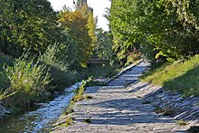
The place lies on both sides of the Liesing south of the Wienerberg . Upstream are the Vienna districts of Atzgersdorf and Erlaa , downstream the Viennese district Rothneusiedl , which is already in the 10th district of Favoriten . The place is in a flat alluvial land, where the river deposited large amounts of Tegel and clay , which were an important raw material for brickworks and the building materials industry. Even today, lakes such as the Steinsee or Schlosssee are evidence of this past, as these lakes are former excavation pits of a closed brick factory that have been converted into a recreational area.
In the 19th century, the lordship or the municipal area of Inzersdorf extended from today's Antonsplatz in the 10th district (south of Reumannplatz ) in the north to almost today's city limits in the south (border to the lordship of today's places Vösendorf , Leopoldsdorf , Oberlaa and Unterlaa ), in the west from the Alt Erlaa / Steinsee area to the Pottendorfer line in the east. Up to the beginning of the 16th century there were two localities in the area of today's Inzersdorf, namely Inzersdorf and Willendorf. The latter was not rebuilt after the destruction of the Turkish siege in 1529; Neusteinhof was built in its place . In 1773, the nucleus of the new district of Neustift (also street houses ) was built on both sides of Triester Straße .
From a geological point of view, Inzersdorf consists largely of Pleistocene gravel. In the southeast and mid-west there is Quaternary clay and loess clay. The north along the Liesing is counted as part of the geological epoch of the Holocene .
history
The first written mention of the place took place between the years 1120 and 1125 as Imicinesdorf or Ymizinisdorf . In 1357 the Triester Straße was called Neustätter Weg. Inzersdorf was already near a main road 2000 years earlier. Inzersdorf was badly destroyed both during the first and the second Turkish siege of Vienna . Maria Katharina von Kinsky brought foreign settlers to the destroyed village twelve years later.
The village developed into a center of Protestant teaching under the Geyer von Osterburg brothers . Many Viennese used the opportunity to “run out” to Inzersdorf in order to escape the measurement route in Vienna. After the old cemetery at the parish church had to be abandoned in 1784, today's Inzersdorfer cemetery was created. After multiple changes of ownership, the "brick baron" Heinrich von Drasche-Wartinberg inherited the rule in 1857. At the time of industrialization , the place became an important industrial location, which mainly specialized in brick production. The brick industry became more and more important over time. In 1872 the factories were producing 100 million bricks, in 1848 there were only 16 million.
Based on this fact, it was decided to incorporate the northern, more developed half of Inzersdorf at the end of the 19th century under the name Inzersdorf-Stadt in today's 10th Viennese district of Favoriten . At the new Vienna city limits, a line office building, which still exists today, was built in 1891 to collect the consumption tax. At the same time, Inzersdorf near Vienna got 17% of the area with around 1% of the population from the municipality of Altmannsdorf, which is also largely integrated into Vienna . At first it was designated as a separate place of the municipality, but it was already integrated in the special place repertory in 1910 into the unified locality of Inzersdorf near Vienna . The incorporation of Inzersdorf-Stadt resulted in a major economic weakening of the remaining town, as the majority of the brickworks were lost, among other things. In the following years, Inzersdorf oriented itself economically mainly to the nearby town of Liesing . The first factories were built in the middle of the 19th century.
A well-known institution that has existed for almost 70 years was established in 1872 when the physician Emil Fries (also: Frieß; 1844–1898) and Hermann Breslauer (also: Breßlauer) built the former summer residence of Prince Ferdinand von Lobkowitz zu Raudnitz (1797–1868 ) and opened it (initially with 25 beds) as a private sanatorium for mentally and mentally ill people (later: sanatorium). (Structural extensions: 1873, 1875, 1881, 1885, 1888, large winter garden 1890, 1902; further development of the park area). Prominent patients included: Joseph Selleny (died in the institution in 1875), Bertha Pappenheim (June – November 1881), Peter Altenberg (December 1910 to September 1911), Josef Weinheber (most recently in 1940 for withdrawal from alcohol).
The Osram incandescent lamp factory was on the border with Atzgersdorf . The location part of this company in Auer-Welsbach-Gasse is shown on both sides of the border of the cadastral communities Atzgersdorf and Inzersdorf as "Altlast W31: Incandescent mantle factory Auer von Welsbach" in the contaminated site atlas from July 1, 2018 .
After the " connection " of Austria to the German Reich Inzersdorf was the law on the creation of " Greater Vienna incorporated" from October 1, 1938, together with Liesing and thirteen other places as the 25th district of Vienna. After the end of the Second World War , Inzersdorf was confirmed in 1954 as part of the 23rd district of Liesing, which now consists of considerably fewer former villages. During the Second World War, the Liesing district was one of the Viennese districts that suffered most from the Allied bombing, as there were many important industrial facilities here. The reconstruction soon made great strides. In 1947 the district suffered from a typhus epidemic.
At the end of the 20th century, new settlements were created in Inzersdorf. The Traviatagasse settlement was built between 1988 and 1991. The individual sections were planned by the architects Carl Pruscha and Raimund Abraham , by Carl Pruscha alone, by Walter Buck and Uta Giencke and by Günther Lautner, Peter Scheifinger and Rudolf Szedenik. The Othellogasse estate was built between 1990 and 1993 under the overall planning of Melicher, Schwalm-Theiss & Gressenbauer. In 1951, at the last census carried out in the independent municipality, Inzersdorf still had 6026 inhabitants, while around 14,500 people already live in Inzersdorf today.
Culture and sights
Originally there was a baroque moated castle from the 17th century in Inzersdorf, as well as a somewhat younger castle built nearby. Both buildings, known as Inzersdorf Castle , were damaged by bombs in the Second World War and finally demolished in 1965 in the course of the construction of the Vienna Südosttangente . The former palace park is now used as a public park under the name Draschepark .
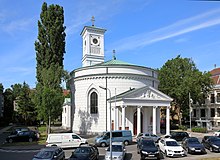
The classicistic parish church of Inzersdorf in the town center was built between 1818 and 1820. It is currently (as of 2011) headed by Pastor Nikolaus Zvonarich, who succeeded Episcopal Vicar Karl Rühringer in 2001 . The so-called Maria-Theresien-Schlössel, located in a spacious park, was built in the first half of the 18th century. It probably originates from an architect from Johann Bernhard Fischer von Erlach's environment . The Grünberger-Schlössl in Draschestraße is a baroque country house built around 1720/30. In addition to these three structures, five other objects are listed in Inzersdorf. One of them, the Inzersdorfer canning factory, was largely demolished in 2010 - a residential complex is to be built on the site.
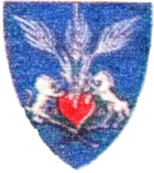
As a motif for the design of the part of the Liesingen coat of arms intended for Inzersdorf, the motif of three ears of wheat growing out of a red heart was chosen, framed on the left and right by a golden lion and a golden horse .
Economy and Infrastructure
There is a large industrial area in Inzersdorf. The Blumental in the east of the district is, for example, the location of the Vienna Wholesale Market ( Magistratsabteilung 59), where agricultural products and flowers are traded on around 300,000 m². One of the best-known companies from Inzersdorf is Inzersdorfer , a company for ready meals that has existed since 1873 and was founded as the “First Austrian military canning factory”. The Wiesbauer sausage manufacturer is also based in Inzersdorf. In 2002 the Austrian State Printing Office moved to the district part. In the same year a letter center of the Austrian Post was opened.
The Draschestrasse elementary school is located in the center of Inzersdorf. The late secessionist - neoclassical school building was built in 1912. A secondary school, a polytechnic course and a kindergarten used to be housed here. The GRG 23 VBS Draschestrasse is just a few house numbers away. This schoolhouse was only built in 1996. Before that, the school was housed in the 12th district of Meidling under the name GRG Singrienergasse 19-21. At that time there was a factory on today's school grounds.
There are two pharmacies in Inzersdorf, the Mariahilf pharmacy and the St. Nikolaus pharmacy, which is named after the parish church.
Personalities
- Franziska Donner (1900–1992), wife of the South Korean President Rhee Syng-man
- Heinrich von Drasche-Wartinberg (1811–1880), industrialist
- Erika Hirsch (1924–1998), musician and composer
- Anton Ölzelt (1817–1875), master builder
- Adelheid Popp (1869–1939), women's rights activist
- Maria Rosa Aloisia Katharina Princess von Kinsky (1783–1842), former owner of the Inzersdorf estate
- Karl Swoboda (1882–1933), world champion in weightlifting
- Hubert Trimmel (1924–2013), cave explorer
- Georg Virilli (1872–1951), Mayor of Inzersdorf
literature
- Georg Freund: Inzersdorf am Wienerberge. Historical-topographical representation of the place and its components from the origin to the most recent times . Self-published by the author, Inzersdorf am Wienerberge 1882. - Full text online .
- Ferdinand Opll : Liesing: History of the 23rd Viennese district and its old places . Jugend und Volk, Vienna 1982, ISBN 3-7141-6217-8 .
- Agnes Streissler: The Inzersdorfer brick workers. A case study of social statistics on industrialization in the Vienna area . Thesis. University of Vienna, Vienna 1991, OBV .
- Margarete Platt: The field names in the 10th, 12th and 13th districts of Vienna and in Inzersdorf . Dissertation. University of Vienna, Vienna 1997, OBV .
- Norbert Kletzl: Inzersdorf is conquering the world. Stories about everyday madness in a part of Vienna . First edition. Frieling, Berlin 2000, ISBN 3-8280-1141-1 .
Web links
- Inzersdorf on the website of the City of Vienna.
- Entry on Inzersdorf (Vienna) in the Austria Forum (in the AEIOU Austria Lexicon )
- History of Inzersdorf until 1848 on the website of the municipality of Liesing ( Memento from June 26, 2012 in the Internet Archive )
Individual evidence
- ^ Wilhelm Rausch, Hermann Rafetseder: Area and name changes of the municipalities of Austria since the middle of the 19th century . Ed .: Hermann Rafetseder (= research on the history of cities and markets in Austria . Volume 2 ). Austrian Working Group for Urban History Research and Ludwig Boltzmann Institute for Urban History Research , 1989, ISBN 3-900387-22-2 , p. 313, 320 .
- ↑ Little Chronicle. [… Dr. Emil Fries. ] In: Neue Freie Presse , Morgenblatt, No. 12227/1898, September 7, 1898, p. 5, top right. (Online at ANNO ). .
- ^ Alma Kreuter: German-speaking neurologists and psychiatrists. A biographical-bibliographical lexicon from the precursors to the middle of the 20th century . Volume 1: Abelsdorff - Gutzmann . Saur, Munich (inter alia) 1996, ISBN 3-598-11196-7 , p. 181.
- ^ Prospect of the sanatorium in Inzersdorf near Vienna . Kainz & Liebhardt, Vienna s. a., ÖNB .
- ^ Freund: Inzersdorf am Wienerberge , p. 115. - Online .
- ↑ Altenberg, Peter . In: zeno.org .
- ^ Christoph Fackelmann: The art of language Josef Weinheber and its readers . Volume 1: Presentation . LIT-Verlag, Vienna 2005, ISBN 3-8258-8620-4 , p. 57, online , and p. 419, online .
- ↑ 1. Contaminated Sites Atlas Regulation Amendment 2018 . Ordinance of the Federal Minister for Sustainability and Tourism amending the Contaminated Sites Atlas, Federal Law Gazette II No. 132/2018.
- ↑ Ferdinand Opll: Liesing: History of the 23rd Viennese district and its old places . Jugend und Volk, Vienna 1982, ISBN 3-7141-6217-8 . P. 198.
Remarks
- ↑ Breßlauer had previously worked in the private clinic of the neurologist Heinrich Obersteiner in Oberdöbling .
- ↑ The 300 m deep property had an area of 2.2 hectares . Their (no longer existing) main building was on the former Feld Gasse , today: Oberlaaer Straße 298. ( ⊙ )
- ↑ Since the boundaries of the census districts and census districts differ from those of the cadastral municipality, no exact number of inhabitants is available. According to the VZ 2001, the counting districts of Blumental , Draschegründe , Inzersdorf , Neu-Erlaa-Neustift and Schwarze Haide had a total of 14,694 inhabitants. - Source: Directory 2001 Vienna , ed. v. Statistics Austria, Vienna 2005, pp. 101-102.
Coordinates: 48 ° 9 ' N , 16 ° 21' E


