Western cape
| Wes-Kaap Western Cape Ntshona-Koloni Western cape
|
||
|---|---|---|
| Symbols | ||
|
||
| Basic data | ||
| Country | South Africa | |
| Capital | Cape Town | |
| surface | 129,462 km² | |
| Residents | 5,822,734 (2011) | |
| density | 45 inhabitants per km² | |
| ISO 3166-2 | ZA toilet | |
| Website | www.westerncape.gov.za (English) | |
| politics | ||
| prime minister | Alan Winds | |
| Political party | THERE | |
Coordinates: 34 ° 0 ′ S , 20 ° 0 ′ E
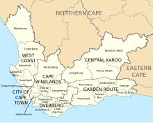
Western Cape ( Afrikaans : Wes-Kaap , English: Western Cape , isiXhosa : Ntshona-Koloni ) is a South African province in the southwest of the republic. It borders both the Atlantic and the Indian Ocean . The province was formed in 1994 from parts of the former Cape Province and is divided into six districts with 24 parishes. The capital of Western Cape is Cape Town . The province also includes the Prince Edward Islands .
With an index value of 0.733 in 2015, the Western Cape has the highest human development index of any province in the country.
geography

The province is 129,462 km² in size, making it a little over a tenth the size of South Africa . It extends from the Cape of Good Hope about 400 km north and about 500 km east along the coasts of the Atlantic and Indian Oceans. In the north, the Western Cape is bordered by the North Cape Province and in the east by the Eastern Cape Province .
Both topographically and climatically, the Western Cape is very diverse. Most of the province is characterized by a warm, temperate climate with cool, humid winters and hot, dry summers, comparable to the Mediterranean climate.
The cold Benguela current has a cooling effect on the climate at the Cape of Good Hope, so that the Western Cape is suitable for viticulture despite its northern location .
Districts with the parishes
The province is divided into the following ten districts with 43 local parishes and one metropolitan municipality :
| District / Metropolitan Municipality | Communities | |
|---|---|---|
| 1. | Cape Winelands | Breede Valley , Drakenstein , Langeberg , Stellenbosch and Witzenberg |
| 2. | Garden Route | Bitou , George , Hessequa , Kannaland , Knysna , Mossel Bay and Oudtshoorn |
| 3. | Overberg | Cape Agulhas , Overstrand , Swellendam and Theewaterskloof |
| 4th | West coast | Bergrivier , Cederberg , Matzikama , Saldanha Bay and Swartland |
| 5. | Central Karoo | Beaufort West , Laingsburg and Prince Albert |
| 6th | City of Cape Town | Metropolitan municipality |
Demographics
According to the 2011 census, there were 5,822,734 people in the Western Cape Province. According to the 2001 census, there were only 4,524,336 people. The population density in 2001 was 34.97 inhabitants / km² with very different settlement densities. The dominant language of the province was Afrikaans (55.3%), followed by Xhosa (23.7%), English (19.3%, mostly in the Cape Town area) and others (<2%).
The residents Western Cape as Colored: 2011 described themselves 48.8% (53.9% in 2001) ( Colored ), 32.8% (2001: 26.7%) than blacks (African), 15.7% (2001: 18 , 4%) as whites and 1.0% (2001: 2.0%) as Indians or Asians.
Population development
The following overview shows the population by area since the 1996 census.
| year | population |
|---|---|
| 1996 (census) | 3,956,875 |
| 2001 (census) | 4,524,335 |
| 2011 (census) | 5,822,734 |
| 2018 (estimate) | 6,621,100 |
politics
In the 2019 elections to the Western Cape Provincial Parliament , the DA remained the strongest party in the Western Cape Province despite losses. Western Cape has been the only South African province since 2009 that is not politically dominated by the ANC. The mandates are distributed as follows.
| Political party | Seats | +/- |
|---|---|---|
| Democratic Alliance (DA) | 24 | −2 |
| African National Congress (ANC) | 12 | −2 |
| Economic Freedom Fighters (EFF) | 2 | +1 |
| Good | 1 | +1 |
| African Christian Democratic Party (ACDP) | 1 | ± 0 |
| Vryheidsfront Plus (VF +) | 1 | +1 |
| Al Jama-ah | 1 | +1 |
| total | 42 |
Education and culture
The province has four universities: Stellenbosch University , the University of Cape Town , the University of the Western Cape in Bellville and the Cape Peninsula University of Technology in Cape Town. It also has the only opera house in South Africa that is open all year round, the Cape Town Opera .
National parks and nature reserves
National parks
- Agulhas National Park
- Bontebok National Park
- Garden Route National Park
- Karoo National Park
- Table Mountain National Park
- West Coast National Park
Nature reserves
|
|
|
Others
License plates from the Province of Western Cape have the abbreviation WP ( Western Cape Province )
Web links
- www.westerncape.gov.za (Provincial Administration website) (English)
- Western Cape Government: Information for Tourists . on www.westerncape.gov.za (English)
Individual evidence
- ^ A b Statistics South Africa : Census 2011, Census in brief . online at www.statssa.gov.za (English, PDF file; 2.8 MB), PDF document p. 23, doc. p. 18.
- ^ Sub-national HDI - Area Database - Global Data Lab. Accessed August 5, 2018 .
- ^ Local Government Handbook. South Africa: Western Cape Municipalities . at www.municipalities.co.za (English).
- ^ Statistics South Africa : Western Cape . on www.statssa.gov.za (English), interactive map.
- ↑ Statistics South Africa: Census 2001 ( Memento from August 10, 2007 in the Internet Archive )
- ↑ South Africa: Provinces and Major Settlements - Population Statistics, Maps, Charts, Weather, and Web Information. Retrieved January 7, 2019 .


