Kumjony
| Urban-type settlement
Kumjony
Кумёны
|
||||||||||||||||||||||||||||||
|
||||||||||||||||||||||||||||||
|
||||||||||||||||||||||||||||||
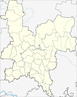
Kumjony ( Russian Кумёны ) is an urban-type settlement in Kirov Oblast in Russia with 4827 inhabitants (as of October 14, 2010).
geography
The place is about 60 km as the crow flies south-south-east of the Kirov Oblast Administrative Center . It is located on the right bank of the eponymous river Bolshaya Kumjona (Great Kumjona), which flows into the Vyatka via the Bystriza .
Kumyony is the administrative center of Kumyonski Rajon and the seat of the municipality of Kumjonskoje gorodskoje posselenije, which also includes the villages of Babkinzy (3 km north), Korepovshchina (4 km south), Morjany (6 km south) and Spasskaya (2 km south).
history
The founding year of the place is 1678, when the first wooden church was built there. From the 18th century it belonged to the Ujesd Vjatka of the Vyatka governorate .
On January 23, 1935, Kumjony became the administrative seat of a newly created Rajons named after him. In 1965 the place received urban-type settlement status.
Population development
| year | Residents |
|---|---|
| 1939 | 681 |
| 1959 | 1603 |
| 1970 | 3730 |
| 1979 | 5394 |
| 1989 | 5588 |
| 2002 | 5249 |
| 2010 | 4827 |
Note: census data
traffic
On the eastern edge of the settlement runs the regional road 33R-002, which begins not far from the Kirov oblast center and continues through the Suna , Nolinsk , Urschum and Malmysh districts further south to Vyatskije Polyany .
The nearest train station is Posdino, about 50 km to the north, on the Trans-Siberian Railway in the southern part of Kirov, which was independent as the city of Novovyatsk until 1989 .
Web links
Individual evidence
- ↑ a b Itogi Vserossijskoj perepisi naselenija 2010 goda. Tom 1. Čislennostʹ i razmeščenie naselenija (Results of the All-Russian Census 2010. Volume 1. Number and distribution of the population). Tables 5 , pp. 12-209; 11 , pp. 312–979 (download from the website of the Federal Service for State Statistics of the Russian Federation)

