
Leninskoye (Kirov)
| Urban-type settlement
Leninskoye
Ленинское
|
||||||||||||||||||||||||||||||||
|
||||||||||||||||||||||||||||||||
|
||||||||||||||||||||||||||||||||
.svg)

Leninskoje ( Russian Ле́нинское ) is an urban-type settlement in Kirov Oblast in Russia with 5054 inhabitants (as of October 14, 2010).
geography
The place is a good 150 km as the crow flies west-southwest of the Kirov Oblast Administrative Center . It is located directly at the source of the left Vetluga -Nebenflusses Bolshaya Kakscha (Grand Kakscha).
Leninskoye is the administrative center of the Rajons Schabalinski and seat of the municipality Leninskoye gorodskoje posselenije. This includes another 37 villages and rural settlements, of which only four have more than 100 inhabitants, while 18 have less than ten or no permanent residents (as of October 14, 2010).

Lenin Monument in Leninskoye
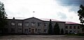
District administration building


history
The founding year of the place is 1854, when the Bogorodskaja Church (from Russian Bogorodiza for " Mother of God ") was built. The village was called Bogorodskoje accordingly . The village named an upswing with the passing of the railway line Saint Petersburg - Vologda - Vyatka (today Kirov) in 1906, which later became part of the main line of the Trans-Siberian Railway on this section . A little east of the village, the station called Schabalino after a nearby settlement was built.
The village of Bogorodskoye received its current name in 1924 after the revolutionary leader Lenin, who died in the same year, and in 1929 became the administrative seat of a newly created Rajon, which was named after the train station. The station settlement was later incorporated into Leninskoje. Since January 10, 1945 the place has had the status of an urban-type settlement.
Population development
| year | Residents |
|---|---|
| 1939 | 2507 |
| 1959 | 4911 |
| 1970 | 5346 |
| 1979 | 5722 |
| 1989 | 5916 |
| 2002 | 5490 |
| 2010 | 5054 |
Note: census data
traffic
In Leninskoje, the Shabalino station is at kilometer 794 of the main line of the Trans-Siberian Railway, which opened on this section in 1906 and has been electrified since 1969 . To the south of the settlement runs the regional road 33K-004, which follows the railway line and, coming from Kotelnitsch via Swetscha , continues to the Kostroma Oblast border about 40 km away (from there in the direction of Ponasyrewo - Sharja ).
Web links
Individual evidence
- ↑ a b c Itogi Vserossijskoj perepisi naselenija 2010 goda. Tom 1. Čislennostʹ i razmeščenie naselenija (Results of the All-Russian Census 2010. Volume 1. Number and distribution of the population). Tables 5 , pp. 12-209; 11 , pp. 312–979 (download from the website of the Federal Service for State Statistics of the Russian Federation)
| Cities |
Belaya Cholunitsa R | Jaransk R | Kirov S | Kirovo-Chepetsk S / R | Kirs R | Kotelnitsch S / R | Lusa R | Malmysch R | Muraschi R | Nolinsk R | Omutninsk R | Orlov R | Slobodskoi S / R | Sosnovka | Sovetsk R | Sujewka R | Urschum R | Vyatskije Polyany S / R |
|
| Urban-type settlements |
Afanassjewo R | Arbasch R | Arkul | Bogorodskoye R | Darovskoy R | Demjanowo | Faljonki R | Jurja R | Kiknur R | Kilmes R | Krasnaya Polyana | Kumjony R | Lalsk | Lebjaschje R | Leninskoye R | Lesnoi | Lyovintsy | Mirny | Murygino | Nagorsk R | Nema R | Nizhnivkino | Oparino R | Oritschi R | Pervomaiski S / G | Peskowka | Pinjug | Pischanka R | Podosinovets R | Rudnichny | Santschursk R | Strishi | Suna R | Svetlopoljansk | Svetscha R | Tuscha R | Uni R | Wachruschi | Verkhozhishye R | Vostochny |