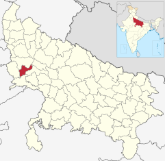
Mahamaya Nagar
| Mahamaya Nagar District | |
|---|---|

|
|
| State | Uttar Pradesh |
| Administrative headquarters : | Hathras |
| Area : | 1840 km² |
| Residents : | 1,564,708 (2011) |
| Population density : | 850 inhabitants / km² |
| Website : | www.hathras.nic.in/ |
Mahamaya Nagar , also Hathras , is a district in the northern Indian state of Uttar Pradesh .
The area is 1840 km². The administrative seat is the city of Hathras .
history
Hathras District was created on May 3, 1997 from parts of Aligarh , Mathura, and Agra Districts . Shortly afterwards he was given the name Hathras (Mahamaya Nagar).
population
The population is 1,564,708 (2011). The population growth rate in the period from 2001 to 2011 was 17.12%. Hathras has a gender ratio of 860 women per 1000 men. The district has a literacy rate of 71.59% in 2011, an increase of almost 9 percentage points compared to 2001. Almost 89% of the population are Hindus and around 10% are Muslims .
The urbanization rate of the district is approximately 21.3%. The largest agglomeration was Hathras with a population of 160,909.
Web links
Individual evidence
- ↑ 2011 census (PDF; 398 kB)
- ^ Indian Districts by Population, Sex Ratio, Literacy 2011 Census. Retrieved April 16, 2019 .
