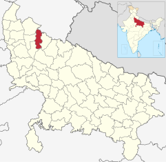
Moradabad (District)
| Moradabad District मुरादाबाद जिला |
|
|---|---|

|
|
| State | Uttar Pradesh |
| Division : | Moradabad |
| Administrative headquarters : | Moradabad |
| Area : | 3718 * km² |
| Residents : | 4,772,006 * (2011) |
| Population density : | 1,283 * inh / km² |
| Website : | moradabad.nic.in |
| *) Figures refer to the Moradabad district before the Sambhal district was split off in 2011. | |
The Moradabad district ( Hindi : मुरादाबाद जिला ) is a district in the Indian state of Uttar Pradesh ; The administrative seat is the eponymous city of Moradabad .
geography
The Moradabad District is located in the Rohilkhand region in northwest Uttar Pradesh and is part of the Moradabad Division . Neighboring districts are Rampur in the east, Sambhal in the south, Amroha in the west, Bijnor in the northwest and Udham Singh Nagar in the northeast. The latter already belongs to the neighboring state of Uttarakhand .
Before the separation of Sambhal District in 2011, Moradabad District had an area of 3718 km². The area belongs to the flat and intensively agriculturally used Ganges plain . The district area is traversed by the Ramganga , a tributary of the Ganges .
The Moradabad District is divided into the four Tehsils Thakurdwara, Kanth, Moradabad and Bilari. The Tehsils Sambhal and Chandausi came to the newly established Sambhal district in 2011.
history
Moradabad District was established by the British in 1801 after the Nawab of Oudh ceded the Rohilkhand region to them. Initially, the Moradabad district also included the area of the later Bijnor and Budaun districts , which were separated from Moradabad as independent districts in 1817 and 1822, respectively. During the British rule, the district was part of the Ceded and Conquered Provinces ( Northwestern Provinces from 1836 ), which became part of the United Provinces of Agra and Oudh in 1902 . After Indian independence in 1947, the United Provinces became the state of Uttar Pradesh.
In 1997 the Amroha District (originally under the name Jyotiba Phule Nagar ) was formed from the western part of the Moradabad District . In 2011 the district area shrank again when the Sambhal (originally Bheemnagar ) district was founded from parts of the Moradabad and Budaun districts .
population
According to the 2011 census, the Moradabad district has 4,772,006 inhabitants according to the old territorial status (all the following information relates to the former district area including the areas that today belong to the Sambhal district). This made the Moradabad district the second largest district in Uttar Pradesh in terms of population after Allahabad . Between 2001 and 2011 the population grew by 25 percent. The Moradabad district is very densely populated: The population density of 1283 inhabitants per km² is well above the already high average of Uttar Pradesh (829 inhabitants per km²). The Moradabad district is relatively urbanized: 33 percent of the district's residents live in cities (the mean value in Uttar Pradesh is 22 percent). The literacy rate, on the other hand, is below average: at 57 percent, it is well below the state average of 68 percent.
Like large parts of the Rohilkhand region, the Moradabad district is strongly influenced by Muslims : According to the 2001 census, Hindus make up just under the majority of the inhabitants of the Moradabad district at 54 percent, while Muslims make up 46 percent of the population. The Muslim population is the second highest in Uttar Pradesh after the neighboring district of Rampur . Muslims even make up the majority of the urban population.
Cities
The following list also includes those cities that have belonged to the Sambhal district since 2011:
| city | Population (2001) |
|---|---|
| Bahjoi | 29,993 |
| Bhojpur Dharampur | 24,395 |
| Bilari | 30,246 |
| Chandausi | 103,757 |
| Kanth | 23,583 |
| Kundarki | 24,540 |
| Moradabad | 641.240 |
| Narauli | 16,682 |
| Rustamnagar Sahaspur | 14,198 |
| Sambhal | 182.930 |
| Sirsi | 21,345 |
| Thakurdwara | 35,279 |
| Umri Kalan | 15,290 |
Individual evidence
- ↑ igovernment.in: Three new districts in Uttar Pradesh, September 28, 2011. ( Memento of March 7, 2014 in the Internet Archive )
- ↑ Census of India 2011: Primary Census Abstract - Uttar Pradesh (PDF; 1.7 MB).
- ↑ ( Page no longer available , search in web archives: Census GIS India: Religions. )
- ↑ Census of India 2001: Population, population in the age group 0-6 and literates by sex - Cities / Towns (in alphabetic order) ( Memento from June 16, 2004 in the Internet Archive )
literature
- The Imperial Gazetteer of India. Volume 17: Mahbūbābād to Morādābād. New edition. Clarendon Press, Oxford 1908, pp. 421-429 , keyword: Morādābād District .
Web links

