Mahoba (district)
| Mahoba District ( Hindi महोबा जिला ) |
|
|---|---|

|
|
| State | Uttar Pradesh |
| Division : | Chitrakoot |
| Administrative headquarters : | Mahoba |
| Area : | 3144 km² |
| Residents : | 875,958 (2011) |
| Website : | Mahoba District |
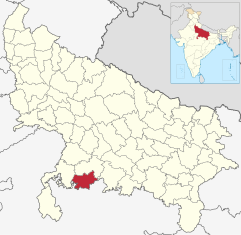
The Mahoba ( Hindi महोबा जिला ) district is a predominantly rural district in the former historic Bundelkhand region in the south of the Indian state of Uttar Pradesh . The administrative center is the city of Mahoba, with a population of around 115,000 .
geography
The Mahoba district is located south of the Ganges plain . The average height is between 150 and 250 m . The average annual rainfall is about 800 mm, of which about 90% falls during the summer monsoon season . The Dhasan River, coming from the southwest, delimits the district in sections to the west and flows into the Betwa .
Neighboring districts are the districts of Jhansi in the west and Hamirpur in the north and east; in the south the district borders on the state of Madhya Pradesh .
Administrative division
Mahoba District is divided into three administrative districts ( tehsils or subdivisions ): Mahoba, Kulpahar, and Charkhari. It consists of the large city of Mahoba (approx. 115,000), the small towns of Charkhari (approx. 30,000), Kabrai (approx. 35,000) and Kulpahar (approx. 25,000) as well as approx. 430 smaller and larger villages.
population
Official population statistics have only been kept and published since 1991.
| year | 1991 | 2001 | 2011 |
| Residents | 625.100 | 758.379 | 875,958 |
Hindus dominate the rural villages (around 90%); The few cities have a significantly higher number of Muslims (around 35%). In the decade between 2001 and 2011, the population grew by around 15% to around 876,000, with the male population exceeding that of the female population by around 12%. Almost 80% of the population lives in rural villages; an average of around 35% of people (and more in rural regions) are illiterate. Mostly Hindi and Bundeli are spoken .
economy
Most of the area of the Mahoba District is still largely agricultural. In the entire district there are ten train stations of rather minor importance on the Jhansi - Banda , Prayagraj line .
history

Almost nothing is known about the early history of the area around Mahoba - it probably belonged to the Kosala Empire, which was soon replaced by the Magadha Empire, which emerged in the 3rd century. v. The Maurya Empire developed. In the 4th / 5th In the 17th century AD, the region became part of the Gupta Empire , which was later replaced by the kings of the Kalachuri , Pratihara and Chandella dynasties. In the High Middle Ages (from around 1200) the rulers of Delhi nominally assumed suzerainty and from 1526 the area was under the control of the Mughal Empire . During its decline after the death of Aurangzeb (1707), the Marathas tried to expand their influence on the Bundelkhand region ; however, they had to cede the area to the British in the Treaty of Bassein (1802) . After India's independence (1947), the state of Uttar Pradesh was established. In 1995, the Mahoba district was re-created through the cession of the neighboring districts.
Attractions
Mahoba
- At Rahil Sagar Lake, about 12 km (driving distance) southwest of the city of Mahoba , there is a Hindu temple from the early Chandella period (around 920) that was half-destroyed by the Muslim armies in around 1203 . It was consecrated to the sun god Surya , but has lost its figure decorations due to the destruction. At its feet there is a stepwell (baoli) with a simple prism structure.
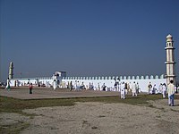
- Also interesting is a situated on the outskirts and on one side by a wall with built mihrab alcove and pulpit ( minbar ) limited Muslim fairground ( 'Īdgāh ) for the holding of the traditional Eid al-Fiṭr- and Eid al-Adha prayers for.
Kulpahar
- There are also several destroyed Hindu temples from the Chandella period in the vicinity of the small town of Kulpahar ; one has a small adjoining stepwell.
Charkhari
- The former princely state of Charkhari , which was founded in 1765 and is located approx. 20 km northwest of Mahoba, is still reminiscent of a representative gate (Dyodhi Gate) in the Indo-Islamic style as well as the three-storey palace of the ruler and the Charkhari fort located on a hill.
literature
- RK Thukral, Shafeeq Rahman (Ed.): Mahoba District Factbook . Datanet India Pvt., New Delhi 2018, ISBN 978-93-86277-24-4 .

