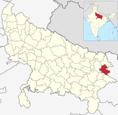
Deoria (district)
| Deoria District देवरिया जिला |
|
|---|---|

|
|
| State | Uttar Pradesh |
| Division : | Gorakhpur |
| Administrative headquarters : | Deoria |
| Area : | 2540 km² |
| Residents : | 3,100,946 (2011) |
| Population density : | 1,221 inhabitants / km² |
| Website : | deoria.nic.in |
The Deoria district ( Hindi : देवरिया जिला ) is a district of the Indian state of Uttar Pradesh . The administrative center is the eponymous city of Deoria .
geography
The Deoria district is located in northeast Uttar Pradesh on the border with the state of Bihar . Neighboring districts are Ballia and Mau in the south, Gorakhpur in the west, Kushinagar in the north (all Uttar Pradesh) and in Bihar Gopalganj and Siwan in the east.
The district area covers an area of 2540 km² and belongs entirely to the flat Ganges plain . In the south, the Deoria district is bounded by the Ghaghara , a large tributary of the Ganges .
Administrative division
Deoria district is part of the Gorakhpur division . It is divided into the five Tehsils Deoria, Salempur, Rudrapur, Berhaj and Bhatpar Rani.
history
The Deoria district has existed as a separate district since 1946. Before that, the area had belonged to the Gorakhpur district. In 1994, the Kushinagar District was formed from the northern part of Deoria District .
population
According to the 2011 Indian census, the Deoria district has 3,100,946 inhabitants. Between 2001 and 2011, the population grew by 15 percent and thus more slowly than the Uttar Pradesh mean (20 percent). The population density of 1221 inhabitants per km² is well above the already high average of the state (829 inhabitants per km²). The district has a very rural character: only ten percent of the population live in cities (the mean value in Uttar Pradesh is 22 percent). At 71 percent, the literacy rate is above the Uttar Pradesh mean (68 percent), but slightly below the overall Indian average (73 percent).
According to the 2001 census , Hindus make up a clear majority of the residents of the district with 88 percent. There is also a Muslim minority of eleven percent.
Cities
| city | Population (2001) |
|---|---|
| Bhatni Bazaar | 14,381 |
| Bhatpar Rani | 12,494 |
| Deoria | 104,222 |
| Gaura Barhaj | 35,279 |
| Gauri Bazaar | 6.224 |
| Lar | 25,492 |
| Majhauli Raj | 17,200 |
| Rampur Karkhana | 9,598 |
| Rudrapur | 28,324 |
| Salempur | 16,906 |
Web links
Individual evidence
- ↑ Census of India 2011: Primary Census Abstract - Uttar Pradesh (PDF; 1.7 MB).
- ^ Census of India 2001: Basic Data Sheet. District Deoria (60), Uttar Pradesh (09). (PDF; 54 kB)
- ↑ Census of India 2001: Population, population in the age group 0-6 and literates by sex - Cities / Towns (in alphabetic order) ( Memento from June 16, 2004 in the Internet Archive )
