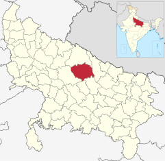
Sitapur (District)
| Sitapur District ( Hindi सीतापुर जिला ) |
|
|---|---|

|
|
| State | Uttar Pradesh |
| Division : | Lucknow |
| Administrative headquarters : | Sitapur |
| Area : | 5743 km² |
| Residents : | 4,489,992 (2011) |
| Website : | Sitapur District |
The Sitapur District ( Hindi सीतापुर जिला ) is a district in the center of the Indian state of Uttar Pradesh . The administrative center is the city of Sitapur , which has around 100,000 inhabitants .
geography
The Sitapur district lies in the Ganges plain . The average height is between 100 and 150 m . The average annual rainfall is about 1195 mm, of which about 90% falls during the summer monsoon season . In the east, the district borders on the Sharda and Ghagara rivers coming from Nepal ; the south-western border is marked by the Gomti River . The Khatna and Ull rivers and the Sharda Canal, which is derived from the Sharda / Mahakali River , also flow through the district .
Neighboring districts are Hardoi in the southwest and west, Lakhimpur Kheri in the north, Bahraich in the east, Barabanki in the southeast and Lucknow in the south.
Administrative division
The Sitapur District is divided into six administrative districts ( tehsils or subdivisions ): Biswan, Mishrikh, Laharpur, Mahmudabad, Sidhauli and Sitapur. It consists of the large city of Sitapur (approx. 200,000), the medium- sized cities Laharpur (approx. 70,000), Biswan (approx. 65,000), Mahmudabad (approx. 60,000) and Khairabad (approx. 55,000), several small towns and approx. 2300 smaller and larger villages.
population
Official population statistics have only been kept and published since 1991.
| year | 1991 | 2001 | 2011 |
| Residents | 2,857,009 | 3,619,661 | 4,489,992 |
Hindus dominate the rural villages (around 80%); A significantly higher number of Muslims (around 35%) live in the cities . In the decade between 2001 and 2011, the population grew by around 25% to around 4.49 million, with the male population exceeding that of the female population by around 13%. Approx. 88% of the population lives in rural villages; an average of just under 40% of people (and more in rural regions) are illiterate. Mostly Hindi is spoken .
economy
Most of the area of the Sitapur district is largely agricultural (wheat, rice, sugar cane, etc.); Small traders, craftsmen, service providers of all kinds and smaller industrial companies have also settled in the cities. There are a total of 32 train stations on five routes in the Sitapur district.
history
The fertile area around Khairabad / Sitapur supplied several large empires in the Ganges plain with food, including the Kosala empire, which was soon replaced by the Magadha empire, from which in the 3rd century BC. The Maurya Empire developed. In the 4th / 5th In the 19th century AD the region came to the Gupta Empire , which was usurped in the early 7th century by its general Harsha , who made Kannauj the capital of his vast territory. The region was later taken over by the kings of the Pratihara and Chandella dynasties. In 1019 Mahmud of Ghazni conquered and devastated large parts of northern India; from 1206 the sultanate of Delhi took over the sovereignty, but at the end of the 14th century the sultanate of Jaunpur , to which the region around Sitapur also belonged, was replaced. After the Battle of Panipat (1526) the area was under the control of the Mughal Empire ; Akbar I. joined the region around Khairabad to the province ( subah ) Oudh . In the phase of the decline of the Mughal Empire after the death of Aurangzeb (1707), the cities largely lost their importance. In 1856 the region came under British rule, but in the following year an uprising developed that also affected Sitapur. After India's independence (1947), the state of Uttar Pradesh was established. In 1997, the district of Kannauj was re-created by assignments of the neighboring districts.
Attractions
Despite the long history of the region, no ancient or medieval temples etc. have been preserved. The most important buildings are the Imambara complex of Khairabad and the Shiva temple of Hargaon .
literature
- RK Thukral, Shafeeq Rahman (Ed.): Sitapur District Factbook . (PDF) Datanet India Pvt., New Delhi 2018, ISBN 978-93-86277-43-5 .
Web links
Individual evidence
- ↑ District Sitapur - Climate table
- ↑ Sitapur District - Map
- ^ Sitapur District - Administrative Divisions and Villages
- ↑ Sitapur District - Census 1991 to 2011
- ↑ Sitapur District - Census 2011
- ^ Sitapur District - Railway Stations
- ↑ Sitapur District - History


