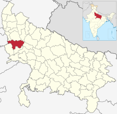
Aligarh (District)
| Aligarh District अलीगढ़ जिला |
|
|---|---|

|
|
| State | Uttar Pradesh |
| Division : | Aligarh |
| Administrative headquarters : | Aligarh |
| Area : | 3650 km² |
| Residents : | 3,673,889 (2011) |
| Population density : | 1007 inhabitants / km² |
| Website : | aligarh.nic.in |
The Aligarh District ( Hindi : अलीगढ़ जिला ) is a district in the northern Indian state of Uttar Pradesh . The administrative headquarters are in the city of Aligarh .
geography
The Aligarh district is located in western Uttar Pradesh in central Doab , the alluvial land between the Ganges and Yamuna rivers . The Ganges forms the border of the district in the east and the Yamuna in the west. The Aligarh District is part of the Aligarh Division . The area of the district is 3648 km². Neighboring districts are Gautam Buddha Nagar and Bulandshahr in the north, Badaun in the northeast, Kanshi Ram Nagar in the east, Amroha and Mathura in the south, and Palwal in the west. The latter already belongs to the neighboring state of Haryana .
Administrative division
The Aligarh District is divided into the five Tehsils Khair, Gabhana, Atrauli, Koil and Iglas.
history
The district of Aligarh was established by the British after they had conquered the area in the Second Marath War in 1803 and incorporated it into British India . During the British rule, the district was part of the Ceded and Conquered Provinces ( Northwestern Provinces from 1836 ), which became part of the United Provinces of Agra and Oudh in 1902 . After Indian independence in 1947, the United Provinces became the state of Uttar Pradesh. In 1997, part of the Aligarh district was added to the newly established Amroha district (then Jyotiba Phule Nagar ).
population
According to the 2011 Indian census, the Aligarh district has 3,673,889 inhabitants. Between 2001 and 2011, the population grew by 23 percent, a little faster than the Uttar Pradesh mean (20 percent). The population density of 1007 inhabitants per km² is above the already high average of the state of 829 inhabitants per km². The district is relatively urbanized: 33 percent of the population live in cities. The degree of urbanization is thus significantly higher than the Uttar Pradesh average (22 percent). The literacy rate, at 68 percent, corresponds to the mean for the state.
According to the 2001 census, Hindus make up the majority of the population of the Aligarh district with 82 percent. There is also a minority of Muslims (18 percent).
Cities
| city | Population (2001) |
|---|---|
| Aligarh | 667.732 |
| Atrauli | 43,845 |
| Beypore | 66,883 |
| Beswan | 5,459 |
| Chharra Rafatpur | 20,826 |
| Harduaganj | 11,564 |
| Iglas | 11,861 |
| Jalali | 17,451 |
| Jatari | 17,038 |
| Kauriaganj | 10,581 |
| Khair | 27,661 |
| Pilkhana | 9,692 |
| Qasimpur Power House Colony | 13,754 |
| Vijaigarh | 5,921 |
Web links
- Aligarh District website
- The Imperial Gazetteer of India. Volume 5: Abāzai to Arcot. New edition Clarendon Press, Oxford 1908, pp. 208-217 , keyword: Aligarh District .
Individual evidence
- ↑ Census of India 2011: Primary Census Abstract - Uttar Pradesh (PDF; 1.7 MB).
- ^ Census of India 2001: Basic Data Sheet: District Aligarh (12), Uttar Pradesh (9). (PDF; 54 kB)
- ^ Census of India 2001: Population, population in the age group 0-6 and literates by sex - Cities / Towns (in alphabetic order). ( Memento from June 16, 2004 in the Internet Archive )
