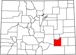
Otero County, Colorado
 The Otero County Courthouse in La Junta |
|
| administration | |
|---|---|
| US state : | Colorado |
| Administrative headquarters : | La Junta |
| Foundation : | 1889 |
| Made up from: | Bent County |
| Demographics | |
| Residents : | 18,831 (2010) |
| Population density : | 5.8 inhabitants / km 2 |
| geography | |
| Total area : | 3289 km² |
| Water surface : | 18 km² |
| map | |
The Otero County is a county in the southeast of the US state of Colorado . The county seat is in La Junta .
geography
The county is surrounded by Counties Crowley in the north, Kiowa in the northwest, Bent in the east, Las Animas in the south and southwest and Pueblo in the west.
history
The county was created in 1889 by splitting off from Bent County . The name of the county comes from Miguel Antonio Otero (1829–1882), a well-known member of the Otero family. Otero was of Hispanic descent and invested as an entrepreneur in what was then New Mexico . Otero County in New Mexico was also named after him .
During World War II, Otero County hosted an American Air Force training camp. Today the square is used as the airport of the city of La Junta.
Demographic data
| growth of population | |||
|---|---|---|---|
| Census | Residents | ± in% | |
| 1890 | 4192 | - | |
| 1900 | 11,522 | 174.9% | |
| 1910 | 20,201 | 75.3% | |
| 1920 | 22,623 | 12% | |
| 1930 | 24,390 | 7.8% | |
| 1940 | 23,571 | -3.4% | |
| 1950 | 25,275 | 7.2% | |
| 1960 | 24,128 | -4.5% | |
| 1970 | 23,523 | -2.5% | |
| 1980 | 22,567 | -4.1% | |
| 1990 | 20.185 | -10.6% | |
| 2000 | 20,311 | 0.6% | |
| 2010 | 18,831 | -7.3% | |
| Before 1900
1900–1990 2000 2010 |
|||
As of the 2000 census , the county had 20,311 people. There were 7,920 households and 5,472 families. The population density was 6 people per square kilometer. The racial the population was composed of 79.02 percent white, 0.76 percent African American, 1.43 percent Native American, 0.70 percent Asian, 0.08 percent of residents from the Pacific island area and 15.06 percent from other ethnic groups Groups; 2.96 percent were descended from two or more races. Hispanic or Latino of any race was 37.62 percent of the total population.
Of the 7,920 households, 32.2 percent had children and young people under the age of 18 living with them. 52.7 percent were married couples living together, 12.0 percent were single mothers. 30.9 percent were not families. 27.8 percent were single households and 12.9 percent had people aged 65 or over. The average household size was 2.49 and the average family size was 3.04.
For the entire county, the population was composed of 26.9 percent of residents under the age of 18, 8.9 percent between 18 and 24 years of age, 24.4 percent between 25 and 44 years of age, and 23.4 percent between 45 and 64 years of age 16.5 percent were 65 years of age or over. The median age was 38 years. For every 100 females there were 95.6 males, and for every 100 females aged 18 and over there were 91.5 males.
The median income for a household in the county is $ 29,738 , and the median income for a family is $ 35,906. Males had a median income of $ 26,996 versus $ 21,001 for females. The per capita income was $ 15,113. 18.8 percent of the population and 14.2 percent of families are below the poverty line. This included 25.9 percent of the population under the age of 18 and 11.8 percent of the population aged 65 and over.
Places in Otero County
Individual evidence
- ↑ GNIS-ID: 198160. Retrieved on February 22, 2011 (English).
- ↑ US Census Bureau - Census of Population and Housing . Retrieved March 15, 2011
- ↑ Extract from Census.gov . Retrieved February 28, 2011
- ↑ Excerpt from factfinder.census.gov.Retrieved February 28, 2011
- ↑ Excerpt from census.gov ( memento of the original from July 16, 2011 on WebCite ) Info: The archive link was inserted automatically and has not yet been checked. Please check the original and archive link according to the instructions and then remove this notice. Retrieved March 31, 2012
Web links
Coordinates: 37 ° 54 ' N , 103 ° 43' W
